


Manila Bulletin
 Philippines
National
'Verbena' to make 5th landfall over Palawan; may strengthen into tropical storm
Philippines
National
'Verbena' to make 5th landfall over Palawan; may strengthen into tropical storm
Philippines
National
'Verbena' to make 5th landfall over Palawan; may strengthen into tropical storm
'Verbena' to make 5th landfall over Palawan; may strengthen into tropical storm
Published Nov 25, 2025 02:51 pm


PAGASA
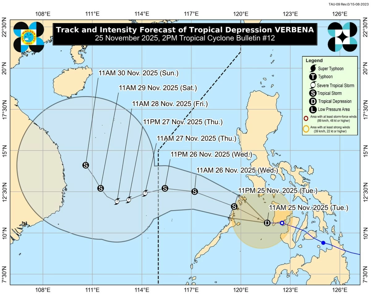
Tropical Depression Verbena, which has made four landfalls since Monday, Nov. 24, continued to move across the Sulu Sea on Tuesday afternoon, Nov. 25, and was expected to pass near or over Cuyo Islands before making its fifth landfall over the northern portion of Palawan on Tuesday evening, the Philippine Atmospheric, Geophysical and Astronomical Services Administration (PAGASA) said.
Verbena’s four landfalls occurred in Bayabas, Surigao del Sur at 1:30 p.m. on Nov. 24; Jagna, Bohol at 11:10 p.m. on Nov. 24; Talisay, Cebu at 2:40 a.m. on Nov. 25; and Vallehermoso, Negros Occidental at 5:50 a.m. on Nov. 25.
As of 1 p.m., the center of Verbena was located over the coastal waters of Magsaysay, Palawan, with maximum sustained winds of 55 kilometers per hour (kph) and gustiness of up to 70 kph. It was moving west at 35 kph.
PAGASA said Verbena may reach tropical storm category within the next 12 hours as it nears northern Palawan.
After crossing northern Palawan Tuesday evening, Verbena is expected to traverse the West Philippine Sea on Wednesday, Nov. 26, before curving west-southwestward and exiting the Philippine Area of Responsibility early Thursday morning, Nov. 27.
Tropical Cyclone Wind Signal No. 1 remains hoisted over Occidental Mindoro, Oriental Mindoro, Romblon, northern and central portions of Palawan (Araceli, Taytay, El Nido, Dumaran, Roxas, San Vicente, Puerto Princesa City), Calamian Islands, Cuyo Islands, Cagayancillo Islands, mainland Masbate (Balud, Mandaon, Milagros, Cawayan, Placer, Pio V. Corpuz, Esperanza, Uson, Dimasalang, Masbate City, Mobo, Palanas, Aroroy, Cataingan, Baleno), Antique, Aklan, Capiz, Iloilo, Guimaras, and the western portion of Negros Occidental (Himamaylan, La Carlota, Bago, Bacolod, Talisay, Silay, Victorias, Kabankalan, and Sipalay).
PAGASA said minimal to minor impacts are possible in these areas.
Should Verbena intensify into a tropical storm, the highest wind signal likely to be raised during its passage is No. 2.
PAGASA also said Verbena will continue to bring heavy rainfall over the next two days.
From Tuesday noon to Wednesday noon, 100 to 200 millimeters of rainfall (heavy to intense) are expected over Occidental Mindoro, Oriental Mindoro, Romblon, Palawan, Antique, Aklan, Capiz, Iloilo, and Guimaras.
Meanwhile, 50 to 100 millimeters of rainfall (moderate to heavy) may prevail over Marinduque, Masbate, Negros Occidental, and Negros Oriental.
From Wednesdsay noon to Thursday noon, Palawan may receive moderate to heavy rainfall.
The shear line, a weather system formed by the collision of cold northeasterly winds (amihan) and warm easterly winds, will also continue to produce significant rainfall over northern and eastern parts of Luzon.
From Tuesday noon until Wednesday noon, 100 to 200 millimeters of rainfall are expected over Cagayan, Isabela, Aurora, Quezon, and Camarines Norte, while 50 to 100 millimeters of rainfall are likely over Apayao, Kalinga, Mountain Province, Ifugao, Nueva Vizcaya, Quirino, Bulacan, Metro Manila, Rizal, Cavite, Laguna, Batangas, Camarines Sur, Catanduanes, Albay, and Sorsogon.
From Wednesday noon to Thursday noon, 100 to 200 millimeters of rainfall may be experienced by Cagayan, Isabela, and Apayao, and 50 to 100 millimeters over Kalinga, Mountain Province, Ifugao, Quirino, and Aurora.
From Thursday noon to Friday noon, Nov. 28, 100 to 200 millimeters of rainfall are expected over Cagayan and Apayao, and 50 to 100 millimeters over Isabela and Kalinga.