


Manila Bulletin
 Philippines
National
'Uwan' maintains strength while moving away; Signal No. 2 still up in parts of Northern Luzon
Philippines
National
'Uwan' maintains strength while moving away; Signal No. 2 still up in parts of Northern Luzon
Philippines
National
'Uwan' maintains strength while moving away; Signal No. 2 still up in parts of Northern Luzon
'Uwan' maintains strength while moving away; Signal No. 2 still up in parts of Northern Luzon
Published Nov 10, 2025 11:24 pm


PAGASA
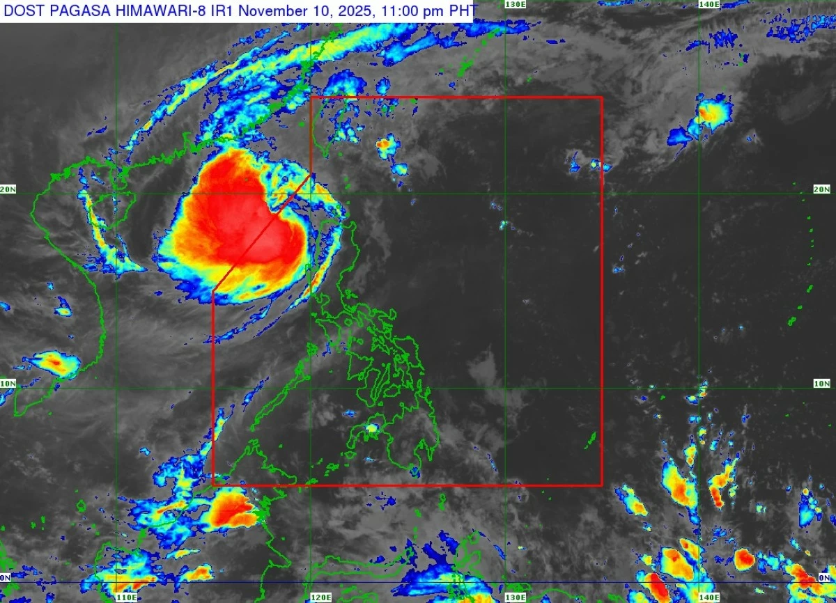
Typhoon Uwan (international name: Fung-wong) continued to move northwestward over the West Philippine Sea late Monday, Nov. 10, while maintaining its strength, the Philippine Atmospheric, Geophysical and Astronomical Services Administration (PAGASA) said.
As of 11 p.m., the center of the eye of Uwan was estimated 245 kilometers west-northwest of Laoag City, Ilocos Norte, or 245 kilometers west-northwest of Sinait, Ilocos Sur.
It was moving northwestward at 15 kilometers per hour (kph), packing maximum sustained winds of 120 kph near the center and gustiness of up to 150 kph.
Signal No. 2 remained raised over Batanes; Cagayan including Babuyan Islands; northwestern portion of Isabela (Santo Tomas, Santa Maria, Quezon, Roxas, Delfin Albano, San Pablo, Cabagan, San Manuel, Mallig); Apayao; Abra; Kalinga; Mountain Province; Ifugao; northern and central portions of Benguet (Mankayan, Kapangan, Atok, Kabayan, Kibungan, La Trinidad, Sablan, Bakun, Buguias, Tublay); Ilocos Norte; Ilocos Sur; northern and central portions of La Union (Luna, Caba, Santol, Bauang, City of San Fernando, San Juan, Bagulin, Aringay, Bangar, San Gabriel, Burgos, Naguilian, Bacnotan, Sudipen, Balaoan); and northwestern portion of Pangasinan (Bolinao, Anda, Bani, Agno).
Signal No. 1 remained in effect over the rest of Isabela; Quirino; Nueva Vizcaya; the rest of Benguet; the rest of La Union; the rest of Pangasinan; Aurora; Nueva Ecija; Zambales; Bataan; Tarlac; Pampanga; Bulacan; Metro Manila; Cavite; Laguna; Batangas; Rizal; Quezon, including Polillo Islands; northern and central portions of Occidental Mindoro (Abra de Ilog, Sablayan, Mamburao, Santa Cruz, Paluan), including Lubang Islands; northern and central portions of Oriental Mindoro (Socorro, Gloria, Naujan, Bansud, Puerto Galera, Victoria, San Teodoro, Baco, Pinamalayan, City of Calapan, Pola); Marinduque; Camarines Norte; and northwestern portion of Camarines Sur (Sipocot, Libmanan, Lupi, Del Gallego, Ragay, Cabusao).
PAGASA said Uwan is forecast to follow a recurving path, turning northward then northeastward on Tuesday, Nov. 11.
A brief re-intensification may occur as it moves over the waters southwest of Taiwan before gradually weakening from Wednesday, Nov. 12, onward.
The typhoon may exit the Philippine Area of Responsibility late Monday or early Tuesday morning but could re-enter by Wednesday evening as it makes landfall over the southwestern coast of Taiwan.
Further weakening is expected as it crosses land and emerges over the waters near the Ryukyu Islands on Thursday, Nov. 13, eventually dissipating into a remnant low by Friday, Nov. 14.