


Manila Bulletin
 Philippines
National
'Uwan' expected to leave PAR on Nov. 11, may re-enter on Nov. 12 — PAGASA
Philippines
National
'Uwan' expected to leave PAR on Nov. 11, may re-enter on Nov. 12 — PAGASA
Philippines
National
'Uwan' expected to leave PAR on Nov. 11, may re-enter on Nov. 12 — PAGASA
'Uwan' expected to leave PAR on Nov. 11, may re-enter on Nov. 12 — PAGASA
Published Nov 10, 2025 12:57 pm
|
Updated Nov 10, 2025 01:26 pm


PAGASA
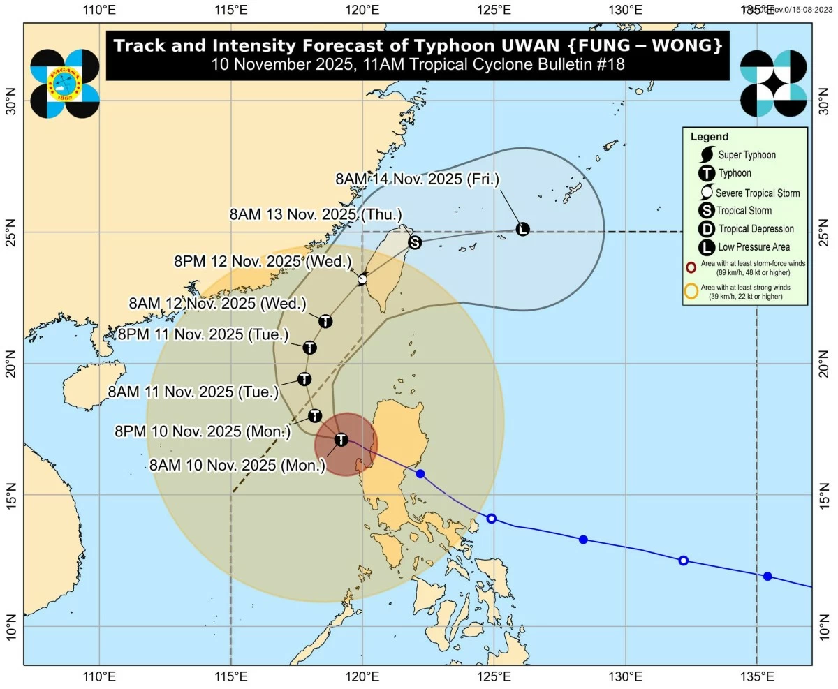
Typhoon Uwan (international name: Fung-wong) is expected to leave the Philippine area of responsibility (PAR) early Tuesday, Nov. 11, but could re-enter on Wednesday, Nov. 12, as it moves over the waters southwest of Taiwan, the Philippine Atmospheric, Geophysical and Astronomical Services Administration (PAGASA) said on Monday, Nov. 10.
The typhoon, which has continued to weaken over the West Philippine Sea, was last tracked 135 kilometers west-northwest of Bacnotan, La Union before Monday noon.
It was moving west-northwestward at 20 kilometers per hour (kph) with maximum sustained winds of 130 kph near the center and gustiness of up to 160 kph.
PAGASA said Uwan will follow a recurving path, turning northwestward later Monday, northward on Tuesday, and northeastward for the rest of the forecast period.
A brief period of re-intensification is possible as the typhoon moves over the waters southwest of Taiwan before gradually weakening starting Wednesday.
“Uwan is forecast to exit PAR tomorrow early morning (Nov. 11),” PAGASA said.
“It may re-enter PAR on Wednesday evening (Nov. 12) as it makes landfall over the southwestern coast of Taiwan,” it added.
After crossing Taiwan, Uwan is expected to further weaken and may eventually dissipate into a low pressure area by Friday, Nov. 14.
Wind signals still in effect
As of Monday morning, Tropical Cyclone Wind Signal No. 3 remained hoisted over Ilocos Sur, northern and central portions of La Union (Luna, Caba, Santol, Bauang, City of San Fernando, San Juan, Bagulin, Aringay, Bangar, San Gabriel, Burgos, Naguilian, Agoo, Bacnotan, Sudipen, and Balaoan), and northwestern portion of Pangasinan (Bolinao, Bani, Agno, City of Alaminos, and Anda) due to the threat of storm-force winds.
Areas under Signal No. 2, where gale-force winds may prevail, include Batanes, Cagayan including Babuyan Islands, Isabela, Quirino, Nueva Vizcaya, Apayao, Abra, Kalinga, Mountain Province, Ifugao, Benguet, Ilocos Norte, the rest of La Union, the rest of Pangasinan, Aurora, Zambales, Bataan, Nueva Ecija, Tarlac, Pampanga, and Bulacan.
Meanwhile, Signal No. 1 remains in effect over Metro Manila, Cavite, Laguna, Batangas, Rizal, Quezon including Polillo Islands, Oriental Mindoro, Occidental Mindoro including Lubang Island, Marinduque, Romblon, northern portion of Palawan (Taytay, Dumaran, El Nido, and Araceli) including Calamian and Cuyo Islands, Camarines Norte, Camarines Sur, Catanduanes, Albay, Sorsogon, northern and western portions of Masbate (City of Masbate, Mobo, Aroroy, Balud, Mandaon, Milagros, and Baleno) including Burias and Ticao Islands, Aklan, Capiz, and northern and central portions of Antique (Pandan, Libertad, Sebaste, Culasi, Tibiao, Barbaza, Bugasong, and Laua-an) including Caluya Islands.
PAGASA also warned of a continuous “high risk of life-threatening and damaging” storm surge with peak heights exceeding three meters within the next 12 hours over the low-lying or exposed coastal areas of Ilocos Region, Cagayan Valley, Central Luzon, Metro Manila, Calabarzon, most of Mimaropa, Aklan, and Antique.
Sea travel remains risky for all types of vessels due to very rough to high seas reaching up to eight meters over the seaboards of northern and central Luzon and the western seaboards of Southern Luzon.
PAGASA advised mariners of small seacrafts not to venture out to sea and to seek shelter until conditions improve.