


Manila Bulletin
 Philippines
National
Super Typhoon Uwan maintains strength; life-threatening conditions persist ahead of landfall
Philippines
National
Super Typhoon Uwan maintains strength; life-threatening conditions persist ahead of landfall
Philippines
National
Super Typhoon Uwan maintains strength; life-threatening conditions persist ahead of landfall
Super Typhoon Uwan maintains strength; life-threatening conditions persist ahead of landfall
Published Nov 9, 2025 11:47 am


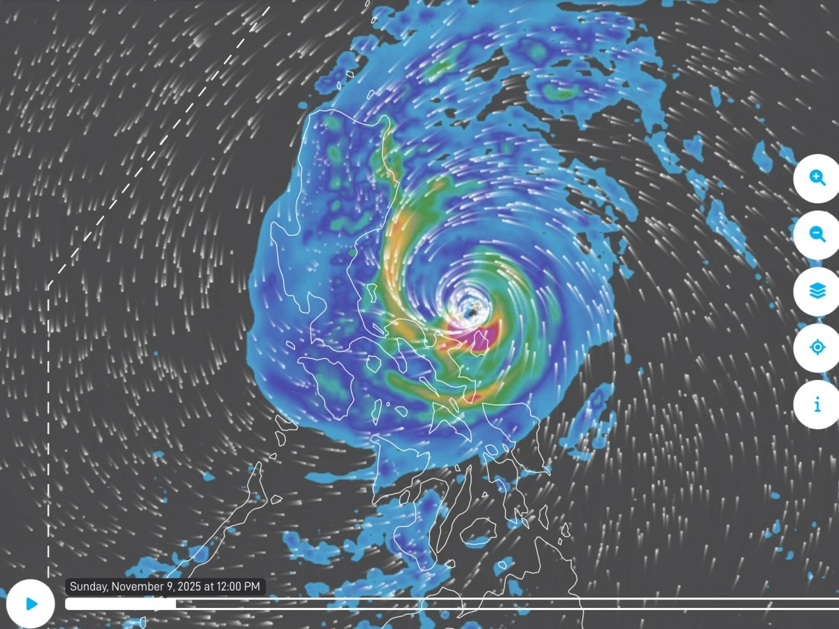
Screengrab from PAGASA’s live satellite imagery of Super Typhoon Uwan (Panahon.gov.ph)
Super Typhoon Uwan (Fung-wong) maintained its strength on Sunday, Nov. 9, as it battered Luzon and parts of Visayas, bringing life-threatening winds, heavy rainfall, and high risk of coastal flooding, the Philippine Atmospheric, Geophysical and Astronomical Services Administration (PAGASA) said on Sunday, Nov. 9.
As of 10 a.m., the center of the eye of Uwan was spotted over the coastal waters of Pandan, Catanduanes, moving west-northwestward at 30 kilometers per hour (kph).
The super typhoon packed maximum sustained winds of 185 kph the center and gustiness of up to 230 kph
On the forecast track, the center of the eye of Super Typhoon Uwan is expected to continue moving over the coastal waters of Catanduanes, passing near Calaguas and Polillo Islands Sunday morning and afternoon, respectively, before making landfall at or near peak intensity—as a super typhoon or upper-limit typhoon—over the central portion of Aurora late Sunday evening or early Monday, Nov. 10.
Given its proximity, PAGASA said a direct hit, with the eyewall affecting the area without actual landfall, is possible over Calaguas and Polillo Islands.
After landfall, Uwan is forecast to traverse the mountainous terrain of northern Luzon and emerge over Lingayen Gulf or the coastal waters of Pangasinan or La Union by Monday morning.
Interaction with the terrain is expected to weaken the typhoon significantly, though it should remain at typhoon strength during its passage over northern Luzon.
From Monday to Tuesday, Nov. 11, Uwan is expected to turn northwestward to northward while remaining at typhoon intensity.
By Wednesday, Nov. 12, the super typhoon is expected to turn northeast toward the Taiwan Strait, gradually weakening, and is projected to make landfall over western Taiwan on Thursday, Nov. 13, before rapidly weakening over land and emerging near the Ryukyu Islands as a remnant low or weak tropical depression.
In its tropical cyclone bulletin issued at 11 a.m., Sunday, PAGASA has maintained Tropical Cyclone Wind Signal No. 5, the highest warning, over the central portion of Aurora (San Luis, Baler, Maria Aurora, Dipaculao), Polillo Islands, northern portion of Camarines Norte (Daet, Talisay, Paracale, Vinzons, Jose Panganiban, Mercedes, Basud), eastern portion of Camarines Sur (Siruma, Caramoan, Garchitorena, Tinambac, Lagonoy), and Catanduanes.
Signal No. 4 is in effect over the southern portion of Isabela (San Agustin, Jones, Echague, Dinapigue, San Guillermo), Quirino, eastern portion of Nueva Vizcaya (Dupax del Sur, Dupax del Norte, Alfonso Castañeda, Kasibu), the rest of Aurora, Nueva Ecija, easternmost portion of Pampanga (Candaba), northern and eastern portions of Bulacan (Doña Remedios Trinidad, San Miguel, San Ildefonso, Norzagaray, San Rafael), northern and eastern portions of Quezon (Tagkawayan, Calauag, Guinayangan, Perez, Alabat, Quezon, Infanta, General Nakar, Real), the rest of Camarines Norte, the rest of Camarines Sur, and northeastern portion of Albay (Rapu-Rapu, Bacacay, City of Tabaco, Malilipot, Malinao, Tiwi, Polangui).
Areas under Signal No. 3 include the southern portion of mainland Cagayan (Tuao, Enrile, Solana, Tuguegarao City, Peñablanca, Iguig, Piat, Amulung), the rest of Isabela, the rest of Nueva Vizcaya, southern portion of Apayao (Conner), Kalinga, Abra, Mountain Province, Ifugao, Benguet, Ilocos Sur, La Union, Pangasinan, Zambales, Bataan, the rest of Pampanga, the rest of Bulacan, Metro Manila, Cavite, Batangas, Rizal, Laguna, the rest of Quezon, Marinduque, the rest of Albay, Sorsogon, Ticao and Burias Islands, and Northern Samar.
Signal No. 2 is in effect over the rest of Cagayan including Babuyan Islands, the rest of Apayao, Ilocos Norte, Occidental Mindoro including Lubang Islands, Oriental Mindoro, Romblon, the rest of Masbate, Eastern Samar, Samar, Biliran, and the northern and central portions of Leyte (Leyte, Calubian, San Isidro, Tabango, Capoocan, Carigara, Barugo, San Miguel, Babatngon, Tacloban City, Alangalang, Tunga, Palo, Santa Fe, Pastrana, Matag-Ob, Tolosa, Mayorga, Julita, Dagami, Jaro, Villaba, La Paz, Tabontabon, Tanauan, Ormoc City, Dulag).
Signal No. 1 is also in effect over Batanes, Calamian Islands, Cuyo Islands, the rest of Leyte, Southern Leyte, Bohol, northern and central portions of Cebu (Medellin, Daanbantayan, City of Bogo, Tabogon, San Remigio, Tabuelan, Borbon, Sogod, Tuburan, Catmon, Carmen, Danao City, Compostela, Liloan, Consolacion, Lapu-Lapu City, Mandaue City, Cordova, Asturias, Cebu City, Balamban, City of Talisay, Toledo City, Minglanilla, Dumanjug, Argao, Sibonga, Barili, Ronda, Moalboal, Badian, Dalaguete, Alcantara, City of Carcar, City of Naga, San Fernando, Pinamungahan, Aloguinsan) including Bantayan and Camotes Islands, northern and central portions of Negros Occidental (City of Escalante, Toboso, Sagay City, Cadiz City, Calatrava, Manapla, City of Victorias, Enrique B. Magalona, Silay City, City of Talisay, San Carlos City, Salvador Benedicto, Murcia, Bacolod City, Hinigaran, City of Himamaylan, Binalbagan, Isabela, Moises Padilla, La Castellana, Pontevedra, San Enrique, La Carlota City, Bago City, Valladolid, Pulupandan), northern portion of Negros Oriental (Canlaon City, Jimalalud, La Libertad, Tayasan, Vallehermoso, City of Guihulngan), Guimaras, Iloilo, Capiz, Aklan, Antique, Dinagat Islands, Surigao del Norte, northern portion of Agusan del Norte (Tubay, Santiago, Jabonga, Kitcharao), and northern portion of Surigao del Sur (Carrascal, Cantilan, Madrid, Carmen, Lanuza, Cortes).
Authorities also warned of life-threatening storm surges exceeding three meters in low-lying coastal communities and extremely rough seas with waves reaching up to 14 meters, urging mariners to stay in port or seek safe harbor immediately.
PAGASA reminded residents to heed evacuation orders, secure property, and take all necessary precautions as Uwan continues to affect the country.