


Manila Bulletin
 Philippines
National
Signal No. 4 up in Catanduanes as Typhoon Uwan intensifies near Bicol region — PAGASA
Philippines
National
Signal No. 4 up in Catanduanes as Typhoon Uwan intensifies near Bicol region — PAGASA
Philippines
National
Signal No. 4 up in Catanduanes as Typhoon Uwan intensifies near Bicol region — PAGASA
Signal No. 4 up in Catanduanes as Typhoon Uwan intensifies near Bicol region — PAGASA
'Uwan' strengthens further as it moves closer to Bicol; super typhoon status possible
Published Nov 9, 2025 12:10 am


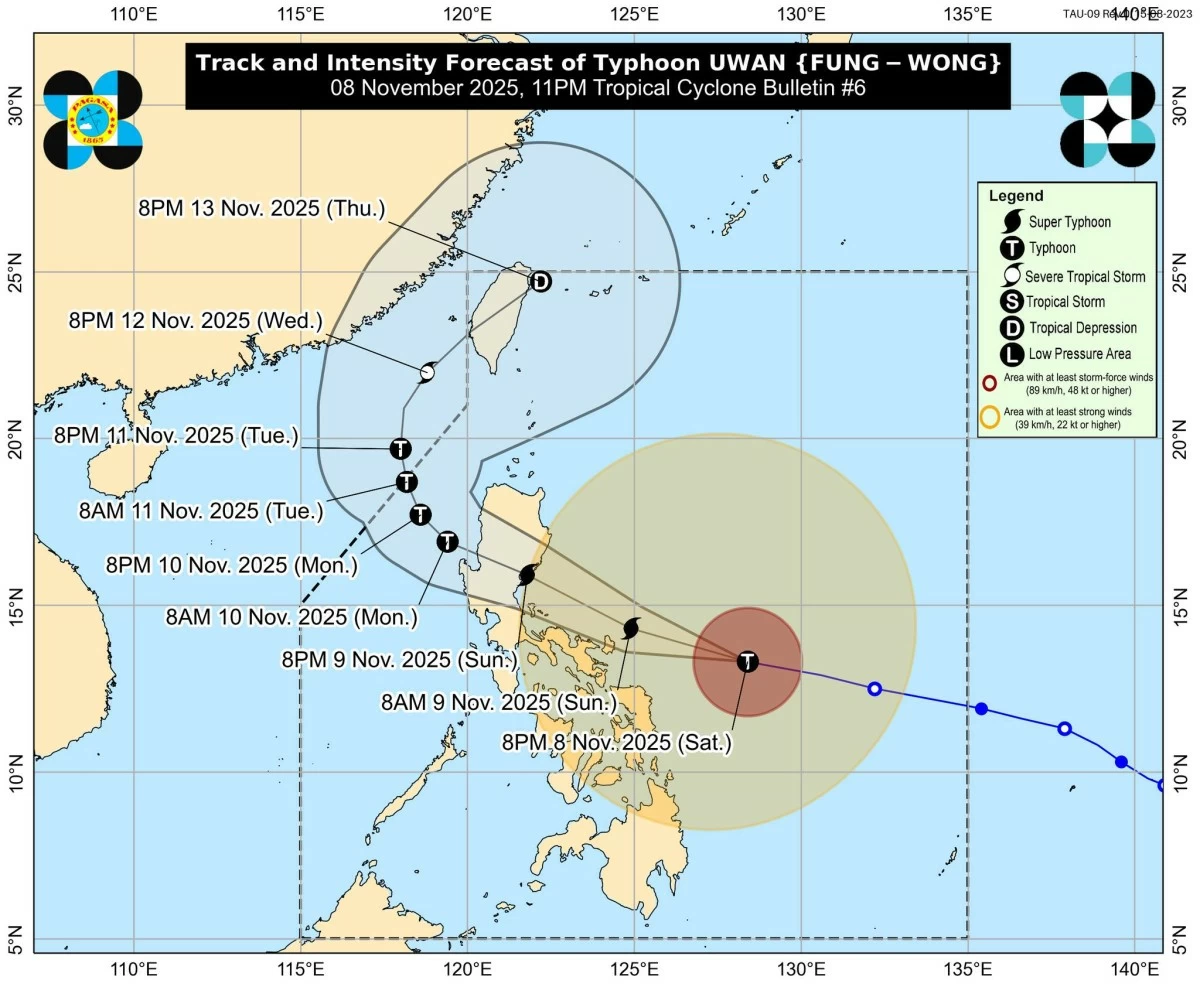
PAGASA raises Signal No. 4 in Catanduanes as Typhoon Uwan intensifies near the Bicol region; it is expected to reach super typhoon strength before making landfall in Aurora or Catanduanes. (PAGASA)
Typhoon Uwan (international name: Fung-wong) has intensified further as it continues to move closer to the Bicol region, prompting the Philippine Atmospheric, Geophysical and Astronomical Services Administration (PAGASA) to raise Tropical Cyclone Wind Signal (TCWS) No. 4 over Catanduanes late Saturday, November 8.
In its 11 p.m. tropical cyclone bulletin, PAGASA located the eye of Typhoon Uwan 380 kilometers east of Virac, Catanduanes, packing maximum sustained winds of 155 km/h near the center and gustiness of up to 190 km/h.
As of 10 p.m., the typhoon was moving west-northwestward at 35 km/h.
The weather bureau said “Uwan” continues to intensify rapidly and may reach the super typhoon category by Sunday, November 9, as it tracks closer to Catanduanes and Aurora province, where landfall is possible by Sunday evening or early Monday, November 10.
"The highest Wind Signal that will likely be hoisted throughout its passage is Wind Signal No. 5," PAGASA said.
Outside the areas under wind signals, PAGASA said “Uwan” will also bring “occasionally gusty conditions reaching strong to gale-force strength” over Palawan and most of Luzon, Visayas, and Mindanao in the following days.
Catanduanes under Signal No. 4; Bicol and parts of Samar under Signal No. 3
PAGASA raised Tropical Cyclone Wind Signal No. 4 over Catanduanes, warning of typhoon-force winds posing a significant to severe threat to life and property.
Meanwhile, areas under Signal No. 3 include:
Luzon - Aurora, Camarines Norte, Camarines Sur, Albay, northern and eastern portions of Quezon (including Polillo Islands), and northern and eastern parts of Sorsogon.
Visayas - Eastern portion of Northern Samar (Palapag, Mapanas, Laoang, Gamay, Catubig, Pambujan, Biri).
These areas may experience storm-force winds (89–117 km/h) and moderate to significant damage to structures and crops.
Metro Manila and Northern Luzon under TCWS No. 2
TCWS No. 2 remains in effect over Metro Manila, Central Luzon, Northern Luzon, and several parts of Southern Luzon and Visayas, where gale-force winds (62–88 km/h) may cause minor to moderate damage.
Luzon - Mainland Cagayan, Isabela, Quirino, Nueva Vizcaya, Apayao, Abra, Kalinga, Mountain Province, Ifugao, Benguet, Ilocos Norte, Ilocos Sur, La Union, Pangasinan, Nueva Ecija, Bulacan, Tarlac, Pampanga, Zambales, Bataan, Metro Manila, Rizal, Laguna, the rest of Quezon, Cavite, Batangas, Marinduque, the northern portion of Oriental Mindoro (Puerto Galera, San Teodoro, Baco, City of Calapan, Naujan, Pola, Victoria), the northern portion of Romblon (Banton), the rest of Sorsogon, and Masbate including Ticao and Burias Islands.
Visayas - The rest of Northern Samar, the northern and central portions of Samar (Matuguinao, San Jose de Buan, Calbayog City, Tagapul-An, Santo Niño, Almagro, San Jorge, San Sebastian, Jiabong, Pagsanghan, Catbalogan City, Gandara, Motiong, Santa Margarita, Tarangnan, Paranas, Hinabangan), the northern and central portions of Eastern Samar (Maslog, San Policarpo, Dolores, Jipapad, Oras, Arteche, Can-Avid, Borongan City, Taft, Sulat, San Julian, Maydolong), and the northern portion of Biliran (Maripipi).
Areas under Signal No. 1
PAGASA said minimal to minor impacts from strong winds are possible within any of the areas under Signal No. 1 which include:
Luzon - Batanes, Babuyan Islands, the rest of Romblon, the rest of Oriental Mindoro, Occidental Mindoro, Calamian Islands, and Cuyo Islands.
Visayas - The rest of Samar, the rest of Eastern Samar, the rest of Biliran, Leyte, Southern Leyte, Bohol, the northern and central portions of Cebu (Medellin, Daanbantayan, Bogo City, Tabogon, San Remigio, Tabuelan, Borbon, Sogod, Tuburan, Catmon, Carmen, Danao City, Compostela, Liloan, Consolacion, Lapu-Lapu City, Mandaue City, Cordova, Asturias, Cebu City, Talisay City, Toledo City, Minglanilla, Dumanjug, Argao, Sibonga, Barili, Ronda, Moalboal, Badian, Dalaguete, Alcantara, Carcar City, Naga City, San Fernando, Pinamungahan, Aloguinsan) including Bantayan and Camotes Islands; the northern and central portions of Negros Occidental (Escalante City, Toboso, Sagay City, Cadiz City, Calatrava, Manapla, Victorias City, Enrique B. Magalona, Silay City, Talisay City, San Carlos City, Salvador Benedicto, Murcia, Bacolod City, Hinigaran, Himamaylan City, Binalbagan, Isabela, Moises Padilla, La Castellana, Pontevedra, San Enrique, La Carlota City, Bago City, Valladolid, Pulupandan), the northern portion of Negros Oriental (Canlaon City, Jimalalud, La Libertad, Tayasan, Vallehermoso, Guihulngan City), Guimaras, Iloilo, Capiz, Aklan, and Antique.
Mindanao - Dinagat Islands, Surigao del Norte, the northern portion of Agusan del Norte (Tubay, Santiago, Jabonga, Kitcharao), and the northern portion of Surigao del Sur (Carrascal, Cantilan, Madrid, Carmen, Lanuza, Cortes).
Heavy rains, storm surge, and high waves expected
PAGASA warned that there is a “high risk of life-threatening and damaging storm surge” with peak heights exceeding 3.0 meters within the next 48 hours over low-lying or exposed coastal communities in Cagayan, Isabela, Ilocos Norte, Ilocos Sur, La Union, Pangasinan, Aurora, Zambales, Bataan, Pampanga, Bulacan, Metro Manila, Cavite, Batangas, Quezon, Camarines Norte, Camarines Sur, Catanduanes, Albay, Sorsogon, Northern Samar, Eastern Samar, Dinagat Islands, and Siargao and Bucas Grande Islands.
Very rough to very high seas reaching up to 14 meters are forecast along the eastern seaboards of Catanduanes, Camarines Sur, Polillo Islands, and Aurora.
“Sea travel is risky for all types or tonnage of vessels,” PAGASA warned. “All mariners must remain in port or, if underway, seek shelter or safe harbor as soon as possible until winds and waves subside,” it added.
Forecast track and possible landfall
PAGASA said “Uwan” will continue moving west-northwestward over the Philippine Sea and pass close to Catanduanes on Sunday morning before potentially making landfall over Aurora province on Sunday evening or early Monday.
A slight southward shift remains possible, which could result in a direct hit on Catanduanes.
After landfall, the typhoon will cross Northern Luzon’s mountainous terrain and may exit via the Lingayen Gulf or the coastal waters of Pangasinan or La Union by Monday morning.
Though expected to weaken over land, PAGASA said “Uwan” will likely remain a typhoon throughout its passage.
Residents urged to prepare, follow evacuation orders
PAGASA urged residents in high-risk areas, especially along coastal and low-lying zones, to prepare for possible evacuations and follow local government advisories.
"Considering these developments, the public and disaster risk reduction and management offices concerned are advised to take all necessary measures to protect life and property," PAGASA said.
READ: