


8 areas under Signal No. 5 as 'Uwan' barrels toward Luzon
Published Nov 9, 2025 02:46 pm


PAGASA
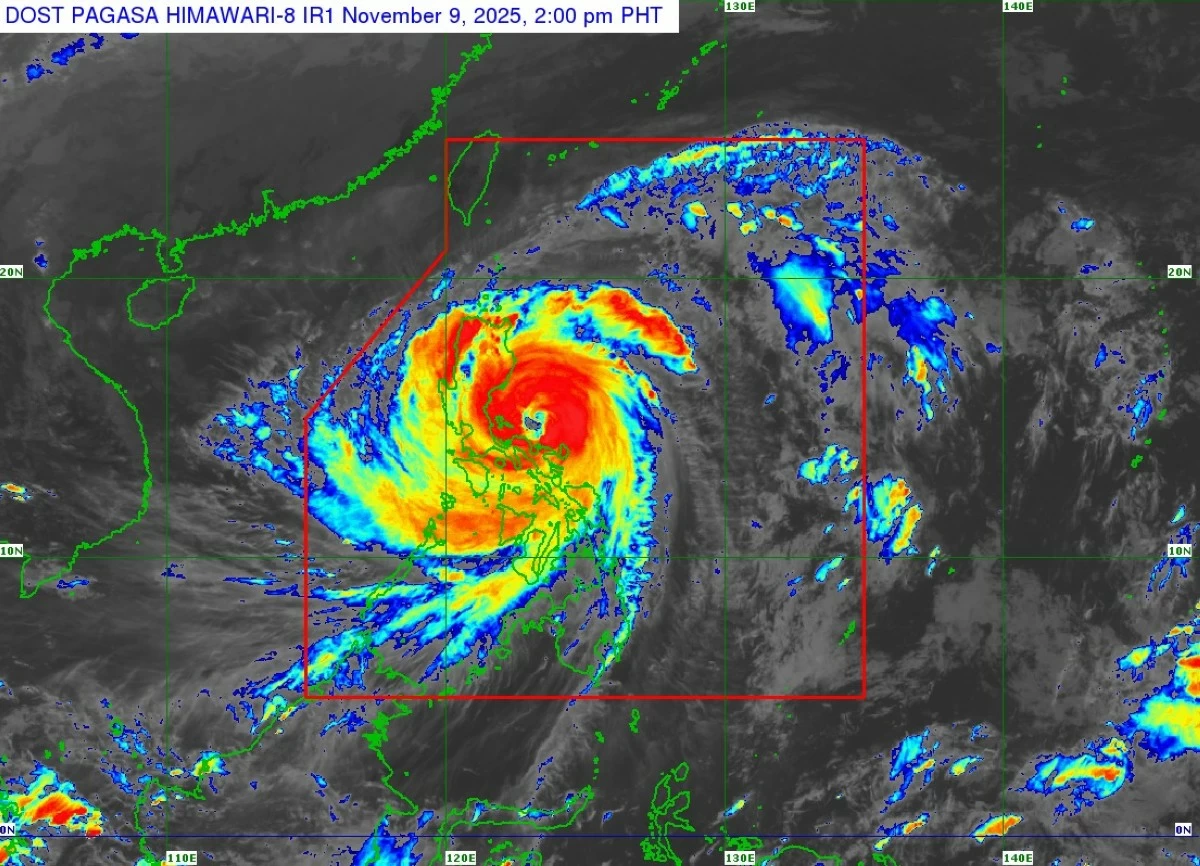
More provinces in Bicol and Central Luzon were placed under Tropical Cyclone Wind Signal No. 5 on Sunday, Nov. 9 as Super Typhoon Uwan (international name: Fung-wong) remained a powerful tropical cyclone while moving closer to Luzon, based on the 2 p.m. bulletin of the Philippine Atmospheric, Geophysical and Astronomical Services Administration (PAGASA).
As of 1 p.m., the center of the eye of Uwan was located 135 kilometers north-northwest of Virac, Catanduanes, or 100 kilometers northeast of Daet, Camarines Norte, moving west-northwestward at 30 kilometers per hour (kph).
It maintained a maximum sustained winds of 185 kilometers per hour near the center and gustiness of up to 230 kph.
Eight areas are currently under Signal No. 5 due to extreme threat from typhoon-force winds:
* Southern Quirino (Nagtipunan)
* Southeastern Nueva Vizcaya (Alfonso Castañeda, Dupax del Norte, Dupax del Sur)
* Northeastern Nueva Ecija (Bongabon, Carranglan, Pantabangan)
* Central Aurora (San Luis, Baler, Maria Aurora, Dipaculao, Dinalungan)
* Polillo Islands
* Northern Camarines Norte (Daet, Talisay, Paracale, Vinzons, Jose Panganiban, Mercedes, Basud)
* Northern and eastern Camarines Sur (Siruma, Caramoan, Garchitorena, Tinambac, Lagonoy)
* Northern Catanduanes (Pandan, Bagamanoc, Panganiban, Viga, Caramoran)
PAGASA warned that extreme impacts are possible, including widespread damage to houses and infrastructure, uprooted trees, and prolonged power and communication outages.
Areas under Signal No. 4, indicating significant to severe threat from typhoon-force winds, include:
* Southern Isabela (San Agustin, Jones, Echague, Dinapigue, San Guillermo, Cordon, Santiago City)
* Rest of Quirino
* Rest of Nueva Vizcaya
* Southern Ifugao (Tinoc, Asipulo, Lamut, Hungduan, Kiangan, Lagawe, Hingyon)
* Benguet
* Southern Ilocos Sur (Sugpon, Alilem)
* La Union
* Pangasinan
* Rest of Aurora
* Rest of Nueva Ecija
* Northernmost Zambales (Santa Cruz)
* Northeastern Tarlac (Camiling, San Clemente, Paniqui, Gerona, Victoria, Pura, Ramos, Moncada, San Manuel, Anao, La Paz, City of Tarlac, Santa Ignacia)
* Eastern Pampanga (Candaba)
* Eastern Bulacan (Doña Remedios Trinidad, San Miguel, San Ildefonso, Norzagaray, San Rafael)
* Northern Rizal (Rodriguez)
* Northern and eastern Quezon (Tagkawayan, Calauag, Guinayangan, Perez, Alabat, Quezon, Infanta, General Nakar, Real, Mauban)
* Rest of Camarines Norte
* Rest of Camarines Sur
* Northeastern Albay (Rapu-Rapu, Bacacay, Tabaco City, Malilipot, Malinao, Tiwi, Polangui)
* Rest of Catanduanes
Signal No. 3, which means moderate to significant threat from storm-force winds, covers:
* Southern mainland Cagayan (Tuao, Enrile, Solana, Tuguegarao City, Peñablanca, Iguig, Piat, Amulung, Santo Niño, Alcala, Rizal)
* Rest of Isabela
* Central and southern Apayao (Conner, Kabugao)
* Abra
* Kalinga
* Mountain Province
* Rest of Ifugao
* Southern Ilocos Norte (Sarrat, Piddig, Paoay, Marcos, Bacarra, Banna, Currimao, Pinili, Carasi, San Nicolas, Dingras, Solsona, Laoag City, Badoc, Batac City, Nueva Era)
* Rest of Ilocos Sur
* Rest of Zambales
* Bataan
* Rest of Tarlac
* Rest of Pampanga
* Rest of Bulacan
* Metro Manila
* Cavite
* Batangas
* Rest of Rizal
* Laguna
* Rest of Quezon
* Marinduque
* Rest of Albay
* Northern Samar
Areas under Signal No. 2, warning of minor to moderate threat from gale-force winds, include:
* Rest of Cagayan, including Babuyan Islands
* Rest of Apayao
* Rest of Ilocos Norte
* Occidental Mindoro, including Lubang Islands
* Oriental Mindoro
* Romblon
* Rest of Masbate
* Eastern Samar
* Samar
* Biliran
* Northern and central Leyte (Leyte, Calubian, San Isidro, Tabango, Capoocan, Carigara, Barugo, San Miguel, Babatngon, Tacloban City, Alangalang, Tunga, Palo, Santa Fe, Pastrana, Matag-Ob, Tolosa, Mayorga, Julita, Dagami, Jaro, Villaba, La Paz, Tabontabon, Tanauan, Ormoc City, Dulag, Burauen, Kananga, Albuera, Palompon, Merida, Isabel)
Signal No. 1, which indicates minimal to minor threat from strong winds, covers:
* Batanes
* Northern Palawan (Taytay, Dumaran, El Nido, Araceli, Roxas), including Calamian, Cuyo, and Cagayancillo Islands
* Rest of Leyte
* Southern Leyte
* Bohol
* Cebu, including Bantayan and Camotes Islands
* Negros Oriental
* Negros Occidental
* Siquijor
* Guimaras
* Iloilo
* Capiz
* Aklan
* Antique
* Dinagat Islands
* Surigao del Norte
* Northern Agusan del Norte (Tubay, Santiago, Jabonga, Kitcharao)
* Northern Surigao del Sur (Carrascal, Cantilan, Madrid, Carmen, Lanuza, Cortes)
Forecast track and intensity
PAGASA said Uwan is expected to continue moving west-northwest over the coastal waters of Camarines Norte Sunday afternoon, passing close to Calaguas and Polillo Islands by evening, before making landfall at or near peak intensity over central Aurora late Sunday evening or early Monday, Nov. 10.
“Due to its proximity, a direct hit—the eyewall passing over without the center actually making landfall—over Calaguas and Polillo Islands is possible,” PAGASA said.
After landfall, the typhoon will traverse the mountainous terrain of Northern Luzon and may emerge over Lingayen Gulf or the coastal waters of Pangasinan or La Union by Monday morning.
The interaction with the terrain is expected to weaken Uwan, but it will likely remain at typhoon strength during its passage.
Uwan will turn northwestward to northward from Monday to Tuesday, Nov. 11, while maintaining typhoon strength, then turn northeastward toward the Taiwan Strait by Wednesday, Nov. 12.
It is expected to make another landfall over western Taiwan on Thursday, Nov. 13, and weaken rapidly over land before emerging near the Ryukyu Islands as a remnant low or weak tropical depression.
PAGASA also warned of intense to torrential rainfall, coastal flooding, and rough to very high seas over most seaboards of Luzon, Visayas, and eastern Mindanao.
A storm surge warning has been raised for Cagayan, Isabela, Ilocos Norte, Ilocos Sur, La Union, Pangasinan, Aurora, Zambales, Bataan, Pampanga, Bulacan, Metro Manila, Cavite, Batangas, Quezon, Camarines Norte, Camarines Sur, Catanduanes, Albay, Sorsogon, Northern Samar, Eastern Samar, Dinagat Islands, and Siargao and Bucas Grande Islands, where waves could exceed three meters in the next 48 hours.