


Manila Bulletin
 Philippines
National
'Uwan' may shift south, threatening a possible direct hit or landfall over Catanduanes — PAGASA
Philippines
National
'Uwan' may shift south, threatening a possible direct hit or landfall over Catanduanes — PAGASA
Philippines
National
'Uwan' may shift south, threatening a possible direct hit or landfall over Catanduanes — PAGASA
'Uwan' may shift south, threatening a possible direct hit or landfall over Catanduanes — PAGASA
Signal No. 2 raised in 8 areas and Signal No. 1 in at least 50 areas, including Metro Manila, ahead of expected Isabela–Aurora landfall
Published Nov 8, 2025 12:41 pm


PAGASA said Typhoon Uwan may shift south, threatening a direct hit or landfall in Catanduanes, with Signal No. 2 raised in eight areas and Signal No. 1 in over 50 regions, including Metro Manila. (PAGASA)
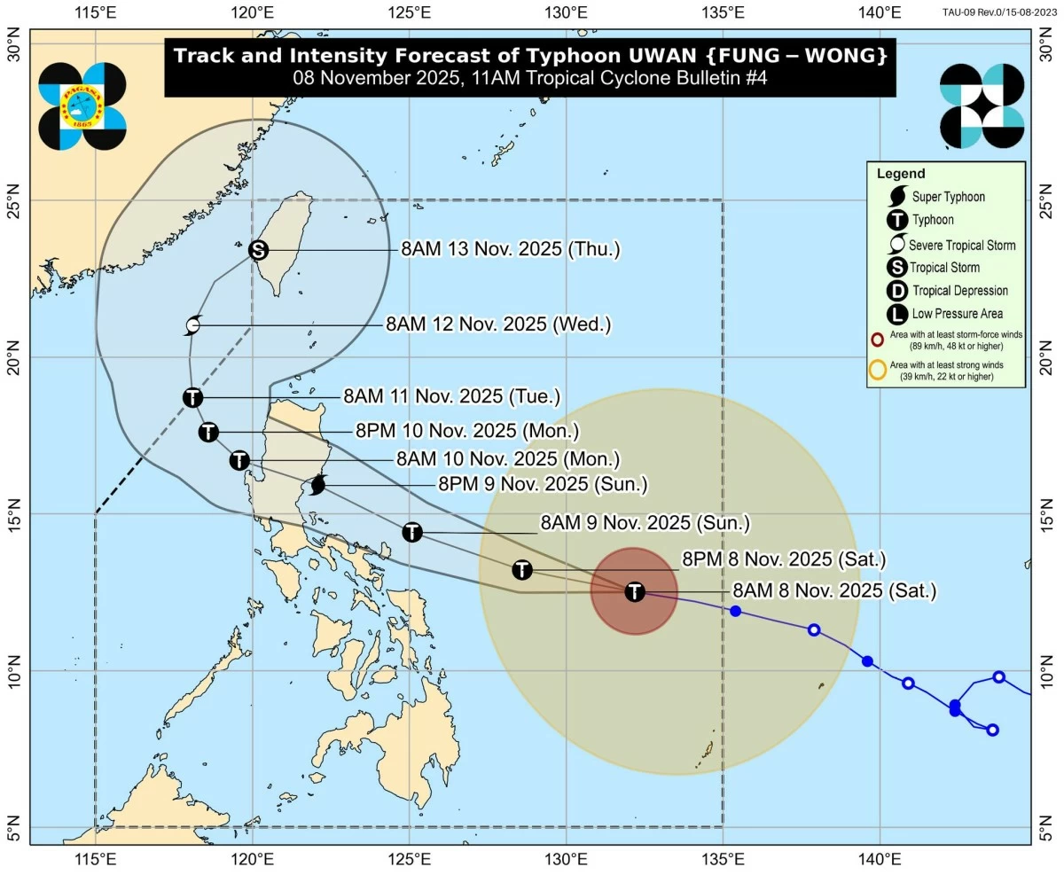
The Philippine Atmospheric, Geophysical and Astronomical Services Administration (PAGASA) on Saturday, November 8, said Typhoon Uwan (international name: Fung-wong) may shift slightly south, increasing the risk of a direct hit or landfall in Catanduanes.
“There is an increasing possibility of a slight southward shift in Uwan’s projected path, which may result in a direct hit (i.e., the eyewall affecting the area without making landfall) or landfall over Catanduanes,” PAGASA said in its 11 a.m. tropical cyclone bulletin.
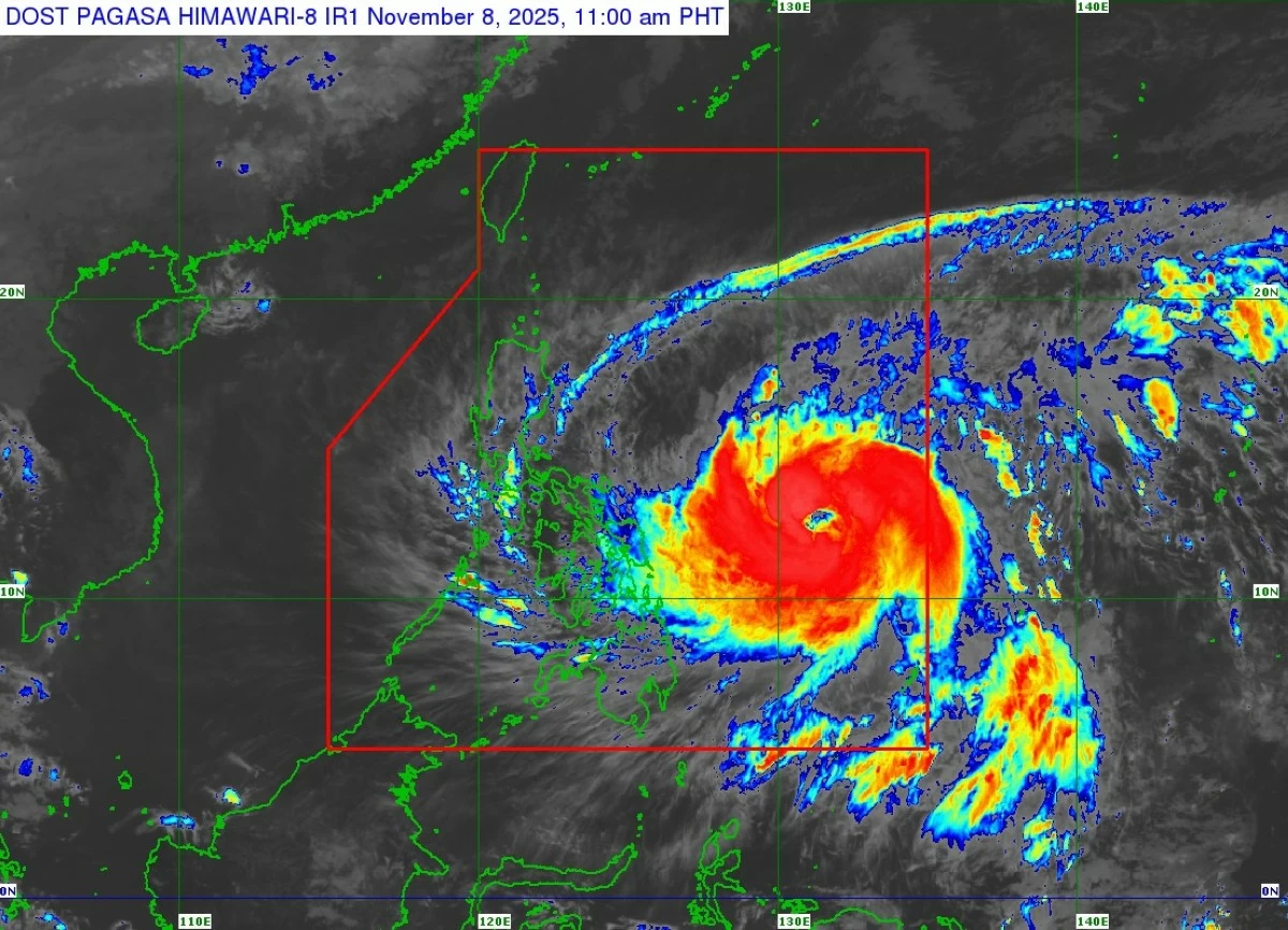
Tropical Cyclone Wind Signal (TCWS) No. 2 has been raised in eight areas, while Signal No. 1 covers at least 50 areas, including Metro Manila, as “Uwan” rapidly intensifies in the last 24 hours over the Philippine Sea east of Eastern Visayas according to PAGASA.
As of 10 a.m., the typhoon’s center was located 680 km east of Borongan City, Eastern Samar, or 760 km east of Catarman, Northern Samar, with maximum sustained winds of 140 km/h, gusts up to 170 km/h, and a central pressure of 965 hPa. It is moving westward at 35 km/h.
PAGASA said “Uwan” has rapidly intensified and is expected to reach super typhoon strength before making landfall over Isabela or Aurora by Sunday evening, November 9, or early Monday, November 10.
Track and intensity outlook
“Uwan” is forecast to move west-northwestward on November 9 before turning more northwestward on November 10.
PAGASA said the center of its eye may pass close to Catanduanes tomorrow morning and make landfall over southern Isabela or northern Aurora on the evening of November 9 or early morning of November 10.
PAGASA
“After landfall, Uwan will traverse the mountainous terrain of Northern Luzon and emerge over Lingayen Gulf or the coastal waters of Pangasinan or La Union on Monday morning or afternoon,” PAGASA said.
PAGASA noted that there remains a possibility of a slight southward shift in Typhoon Uwan’s track, which may result in a direct hit on Catanduanes even without landfall.
The typhoon is forecast to rapidly intensify and may reach super typhoon category tonight or tomorrow. Faster intensification is possible due to favorable conditions. “It may also make landfall at or near its peak intensity,” PAGASA added.
Once it crosses Luzon’s mountain ranges, PAGASA said “Uwan” will likely weaken slightly but remain a typhoon as it moves toward the West Philippine Sea on Monday.
Areas under Tropical Cyclone Wind Signal
Eight areas are now under Signal No. 2, while at least 50, including Metro Manila and parts of Central and Northern Luzon, are under Signal No. 1.
PAGASA said areas provinces under TCWS No. 2, which warns of gale-force winds that pose minor to moderate threats to life and property within 24 hours, include Catanduanes, the eastern portion of Camarines Sur, Albay, Sorsogon, Ticao Islands, Northern Samar, and northern Eastern Samar.
Areas under Signal No. 1, which may experience strong winds within 36 hours with minimal to minor impacts, include:
Luzon - Batanes, Cagayan, Isabela, Quirino, Nueva Vizcaya, Apayao, Abra, Kalinga, Mountain Province, Ifugao, Benguet, Ilocos Norte, Ilocos Sur, La Union, Pangasinan, Aurora, Nueva Ecija, Bulacan, Tarlac, Pampanga, Zambales, Bataan, Metro Manila, Cavite, Laguna, Batangas, Rizal, Quezon, Camarines Norte, the rest of Camarines Sur, the rest of Masbate including Burias Island, Marinduque, Romblon, Oriental Mindoro, Occidental Mindoro including Lubang Islands, Calamian Islands, and Cuyo Islands
Visayas - the rest of Samar, the rest of Eastern Samar, Biliran, Leyte, Southern Leyte, northeastern Bohol, northern and central Cebu, including Bantayan and Camotes Islands, northern Negros Occidental, northern and central Iloilo, Capiz, Aklan, and northern and central Antique, including Caluya Islands
Mindanao - Dinagat Islands and Surigao del Norte
Heavy rains, flooding, and storm surge threats
PAGASA said “Uwan” is forecast to bring torrential rains to Bicol, Eastern Visayas, and parts of Northern Luzon beginning Sunday.
Based on PAGASA’s Weather Advisory No. 6, possible widespread flooding and landslides, particularly in Catanduanes, Albay, Sorsogon, Northern Samar, and Eastern Samar, may be expected.
A Storm Surge Warning No. 3 has been raised for life-threatening coastal inundation exceeding three meters in low-lying areas of Batanes, Cagayan, Ilocos provinces, Pangasinan, Aurora, Zambales, Bataan, Metro Manila, Quezon, Camarines provinces, Albay, Sorsogon, Northern Samar, and Dinagat Islands within 48 hours.
A Gale Warning is also in effect over the northern and eastern seaboards of Luzon, eastern Visayas, and northeastern Mindanao. Sea conditions are expected to be very rough to high, with waves up to 14 meters along the eastern coasts of Catanduanes and Camarines Norte and Sur.
PAGASA strongly advised fisherfolk and operators of small vessels to avoid sea travel due to intense winds and large waves.
Disaster risk reduction and management offices have been instructed to prepare evacuation plans and monitor at-risk communities, especially in flood-prone and coastal areas.
“The public is advised to take all necessary measures to protect life and property,” PAGASA said. “Residents in high-risk zones should follow evacuation instructions and stay updated through official advisories,” it added.
RELATED STORY: