


Manila Bulletin
 Philippines
National
PAGASA: 'Uwan' intensifies, may reach super typhoon strength before Isabela-Aurora landfall
Philippines
National
PAGASA: 'Uwan' intensifies, may reach super typhoon strength before Isabela-Aurora landfall
Philippines
National
PAGASA: 'Uwan' intensifies, may reach super typhoon strength before Isabela-Aurora landfall
PAGASA: 'Uwan' intensifies, may reach super typhoon strength before Isabela-Aurora landfall
Signal No. 2 up in Catanduanes, Northern Samar, Eastern Samar; Signal No. 1 in Metro Manila, Central and Northern Luzon, and parts of Visayas and Mindanao
Published Nov 8, 2025 05:51 am


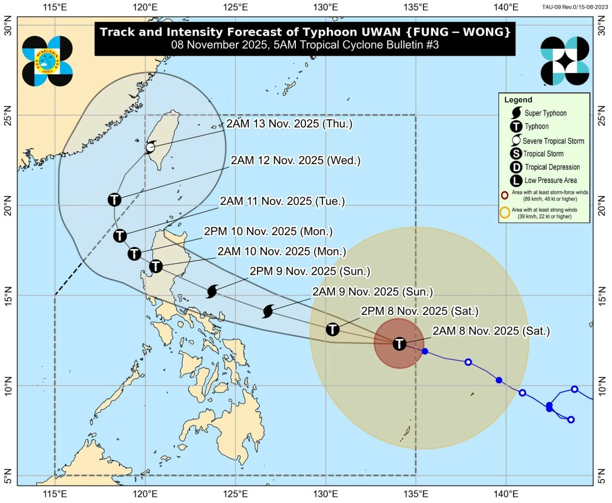
PAGASA said Typhoon Uwan (Fung-wong) has intensified and may reach super typhoon strength before making landfall over Isabela or Aurora. Signal Nos. 1 and 2 are raised across Luzon and Visayas, with warnings of torrential rains, 3-meter storm surges, and dangerous sea conditions. (PAGASA)
Typhoon Uwan (international name: Fung-wong) has further intensified while moving west-northwestward over the Philippine Sea east of Eastern Visayas, according to the Philippine Atmospheric, Geophysical and Astronomical Services Administration (PAGASA) on Saturday, November 8.
In its tropical cyclone bulletin issued at 5 a.m., PAGASA warned that “Uwan” could reach super typhoon category within 24 hours as it approaches the Luzon landmass.
As of 4 a.m., PAGASA said the center of “Uwan” was located 985 kilometers east of Eastern Visayas, packing maximum sustained winds of 130 km/h, gustiness of up to 160 km/h, and a central pressure of 965 hPa.
The typhoon is moving west-northwest at 25 km/h, with strong to typhoon-force winds extending outward up to 780 kilometers from the center.
‘Uwan’ may make landfall late Sunday or early Monday
PAGASA said “Uwan” is forecast to continue moving west-northwestward until Monday, November 10, before turning generally north-northwestward by Tuesday, November 11.
Based on the latest track, the typhoon’s center may make landfall over the southern portion of Isabela or the northern portion of Aurora between Sunday night, November 9, and early Monday morning.
After crossing Northern Luzon’s mountainous terrain, PAGASA said “Uwan” is expected to weaken slightly but remain a typhoon as it moves into the West Philippine Sea by Monday afternoon.
Signal No. 2 raised in parts of Bicol and Eastern Visayas
PAGASA has raised Tropical Cyclone Wind Signal (TCWS) No. 2 in Catanduanes; the eastern and central portions of Northern Samar (Lope de Vega, Palapag, Las Navas, Mapanas, Laoang, Catubig, Mondragon, Lapinig, Pambujan, Catarman, San Roque, Silvino Lobos, Gamay); the northeastern portion of Samar (Matuguinao, San Jose de Buan); and the northern portion of Eastern Samar (Maslog, San Policarpo, Dolores, Jipapad, Oras, Arteche).
These areas may experience gale-force winds (62–88 km/h) within 24 hours, with minor to moderate threats to life and property.
Meanwhile, Signal No. 1 is hoisted over a wide area covering Metro Manila, most of Luzon, Central Visayas, and parts of Mindanao, including:
Luzon: Cagayan including Babuyan Islands, Isabela, Quirino, Nueva Vizcaya, Apayao, Abra, Kalinga, Mountain Province, Ifugao, Benguet, Ilocos Norte, Ilocos Sur, La Union, Pangasinan, Aurora, Nueva Ecija, Bulacan, Tarlac, Pampanga, Zambales, Bataan, Metro Manila, Cavite, Laguna, Batangas, Rizal, Quezon including Polillo Islands, Camarines Norte, Camarines Sur, Albay, Sorsogon, Masbate including Ticao Island and Burias Islands, Marinduque, Romblon, Oriental Mindoro, Occidental Mindoro including Lubang Islands, and Calamian Islands
Visayas: The rest of Northern Samar, the rest of Samar, the rest of Eastern Samar, Biliran, Leyte, Southern Leyte, the northeastern portion of Bohol (Getafe, Talibon, Buenavista, Trinidad, San Miguel, Ubay, Alicia, Mabini, Bien Unido, Pres. Carlos P. Garcia), the northern and central portions of Cebu (Medellin, Daanbantayan, City of Bogo, Tabogon, San Remigio, Tabuelan, Borbon, Sogod, Tuburan, Catmon, Carmen, Danao City, Compostela, Liloan, Consolacion, Lapu-Lapu City, Mandaue City, Cordova, Asturias, Cebu City, Balamban, City of Talisay, Toledo City, Minglanilla) including Bantayan and Camotes Islands, the northern portion of Negros Occidental (City of Escalante, Toboso, Sagay City, Cadiz City, Calatrava, Manapla, City of Victorias, Enrique B. Magalona, Silay City, City of Talisay, San Carlos City, Salvador Benedicto, Murcia, Bacolod City), the northern and central portions of Iloilo (Carles, Estancia, Balasan, San Dionisio, Concepcion, Batad, Sara, Ajuy, Barotac Viejo, San Rafael, Lemery, Lambunao, Calinog, Bingawan, City of Passi, San Enrique, Anilao, Banate, Dingle, Dueñas, Janiuay, Badiangan, Mina, Pototan, Barotac Nuevo, Dumangas), Capiz, Aklan, and the northern and central portions of Antique (Pandan, Libertad, Sebaste, Culasi, Valderrama, Tibiao, Barbaza, Laua-An, Bugasong) including Caluya Islands
Mindanao: Dinagat Islands and Surigao del Norte
These areas may experience strong winds (39–61 km/h) within 36 hours, with minimal to minor damage expected.
Heavy rains, storm surges, and coastal flooding expected
PAGASA warned of heavy to torrential rains across Bicol, Eastern Visayas, and parts of Northern Luzon beginning Sunday, November 9. Based on Weather Advisory No. 5, rainfall may exceed 200 millimeters in some areas, increasing the risk of flash floods and landslides.
READ:
A high risk of life-threatening storm surges exceeding 3 meters is also expected within the next 48 hours along low-lying coastal communities of Isabela, Aurora, Quezon (including Polillo Islands), Camarines Norte, Camarines Sur, Catanduanes, Albay, Sorsogon, Northern Samar, and Eastern Samar.
Sea travel remains risky
A Gale Warning is in effect for the northern and eastern seaboards of Luzon and the eastern seaboard of Visayas, where waves may reach up to 14 meters high. PAGASA strongly advised all mariners and operators of small sea vessels to avoid sea travel due to very rough to high seas.
PAGASA cautioned that Wind Signal No. 5 — the highest alert level — may still be raised over some areas as “Uwan” continues to intensify. The public, especially those in high-risk and coastal communities, is advised to take precautionary measures, prepare emergency kits, and follow evacuation orders from local authorities.
“Considering these developments, the public and disaster risk reduction and management offices concerned are advised to take all necessary measures to protect life and property,” PAGASA said.
For local weather updates, rainfall advisories, and thunderstorm warnings, the public is urged to monitor bulletins from PAGASA and their respective regional offices.
RELATED STORY: