


Manila Bulletin
 Philippines
National
PAGASA raises Signal No. 3 in 5 areas as 'Uwan' rapidly intensifies near Bicol
Philippines
National
PAGASA raises Signal No. 3 in 5 areas as 'Uwan' rapidly intensifies near Bicol
Philippines
National
PAGASA raises Signal No. 3 in 5 areas as 'Uwan' rapidly intensifies near Bicol
PAGASA raises Signal No. 3 in 5 areas as 'Uwan' rapidly intensifies near Bicol
Typhoon Uwan gains strength over the Philippine Sea; storm-force winds and heavy rainfall are expected in affected regions
Published Nov 8, 2025 06:01 pm


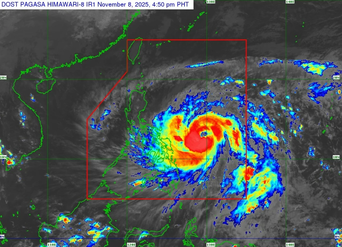
PAGASA has raised Tropical Cyclone Wind Signal No. 3 in five areas as Typhoon Uwan nears the Philippines, bringing heavy rains, strong winds, and hazardous coastal conditions. (PAGASA)
The Philippine Atmospheric, Geophysical and Astronomical Services Administration (PAGASA) has raised Tropical Cyclone Wind Signal (TCWS) No. 3 in five areas as Typhoon Uwan (international name: Fung-wong) rapidly intensifies over the Philippine Sea, east of the Bicol region.
In its tropical cyclone bulletin issued at 5 p.m. on Saturday, November 8, PAGASA said the eye of Typhoon Uwan was located approximately 575 km east of Catarman, Northern Samar, or 620 km east of Virac, Catanduanes, moving west-northwest at 30 km/h as of 4 p.m.
The typhoon now packs maximum sustained winds of 150 km/h near the center, with gusts reaching 185 km/h and a central pressure of 955 hPa, PAGASA said.
Strong to typhoon-force winds extend up to 800 km from its center, the weather bureau added.
Areas under Signal No. 3
PAGASA issued Tropical Cyclone Wind Signal (TCWS) No. 3—indicating storm-force winds of 89 to 117 km/h with a warning lead time of 18 hours—for the following areas:
Luzon – Catanduanes; eastern portions of Camarines Sur (Siruma, Tinambac, Goa, Lagonoy, Caramoan, Tigaon, Garchitorena, Sagnay, San Jose, Presentacion); eastern portions of Albay (Tiwi, Santo Domingo, Malinao, Rapu-Rapu, Tabaco City, Bacacay, Malilipot); and the northeastern portion of Sorsogon (Prieto Diaz).
Visayas – northeastern portion of Northern Samar (Palapag, Mapanas, Laoang).
PAGASA warned that areas under Signal No. 3 face a moderate to significant threat to life and property due to strong winds. Residents are advised to secure their homes, evacuate if necessary, and avoid coastal and exposed areas.
Signal No. 2 (gale-force winds, 62–88 km/h) covers additional parts of Luzon and Visayas, including:
Luzon – the eastern portion of mainland Cagayan, Isabela, Quirino, Nueva Vizcaya, Aurora, Nueva Ecija, Bulacan, Metro Manila, Rizal, Laguna, Quezon, Marinduque, Camarines Norte, the rest of Camarines Sur, the rest of Albay, the rest of Sorsogon, Burias Island, and Ticao Island.
Visayas – the rest of Northern Samar; the northern portion of Samar (Matuguinao, San Jose de Buan, Calbayog City, Tagapul-An, Santo Niño, Almagro, San Jorge, San Sebastian, Jiabong, Pagsanghan, City of Catbalogan, Gandara, Motiong, Santa Margarita, Tarangnan, Paranas, Hinabangan); and the northern portion of Eastern Samar (Maslog, San Policarpo, Dolores, Jipapad, Oras, Arteche, Can-Avid, City of Borongan, Taft, Sulat, San Julian, Maydolong).
Signal No. 1 (strong winds, 39–61 km/h) is in effect for:
Luzon – Batanes; the rest of Cagayan including Babuyan Islands; Apayao; Abra; Kalinga; Mountain Province; Ifugao; Benguet; Ilocos Norte; Ilocos Sur; La Union; Pangasinan; Tarlac; Pampanga; Zambales; Bataan; Cavite; Batangas; the rest of Masbate; Romblon; Oriental Mindoro; Occidental Mindoro including Lubang Islands; Calamian Islands; and Cuyo Islands.
Visayas – the rest of Samar; the rest of Eastern Samar; Biliran; Leyte; Southern Leyte; Bohol; the northern and central portions of Cebu (Medellin, Daanbantayan, City of Bogo, Tabogon, San Remigio, Tabuelan, Borbon, Sogod, Tuburan, Catmon, Carmen, Danao City, Compostela, Liloan, Consolacion, Lapu-Lapu City, Mandaue City, Cordova, Asturias, Cebu City, Balamban, City of Talisay, Toledo City, Minglanilla, Dumanjug, Argao, Sibonga, Barili, Ronda, Moalboal, Badian, Dalaguete, Alcantara, City of Carcar, City of Naga, San Fernando, Pinamungahan, Aloguinsan) including Bantayan and Camotes Islands; the northern portion of Negros Occidental (City of Escalante, Toboso, Sagay City, Cadiz City, Calatrava, Manapla, City of Victorias, Enrique B. Magalona, Silay City, City of Talisay, San Carlos City, Salvador Benedicto, Murcia, Bacolod City, Hinigaran, City of Himamaylan, Binalbagan, Isabela, Moises Padilla, La Castellana, Pontevedra, San Enrique, La Carlota City, Bago City, Valladolid, Pulupandan); the northern portion of Negros Oriental (Canlaon City, Jimalalud, La Libertad, Tayasan, Vallehermoso, City of Guihulngan); Guimaras; Iloilo; Capiz; Aklan; and Antique.
Mindanao – Dinagat Islands, Surigao del Norte, the northern portion of Agusan del Norte (Tubay, Santiago, Jabonga, Kitcharao), and the northern portion of Surigao del Sur (Carrascal, Cantilan, Madrid, Carmen, Lanuza, Cortes).
PAGASA said Typhoon Uwan is expected to intensify rapidly, potentially reaching super typhoon status tonight or by Saturday, November 9.
Heavy rainfall, storm surges, and rough seas are expected across affected coastal areas, especially in Bicol, Northern Samar, Eastern Samar, and parts of Luzon, PAGASA added.
“Heavy rainfall, severe winds, and storm surges may still be experienced in localities far from the landfall point and outside the forecast confidence cone,” PAGASA said.
PAGASA also emphasized that the typhoon may make landfall near Catanduanes, southern Isabela, or northern Aurora, and its winds, rains, and storm surges could still affect areas far from the projected path.
“Uwan is forecast to move west-northwestward today and tomorrow (9 November) before turning generally more northwestward on Monday (10 November),” PAGASA said.
“On the track forecast, the center of the eye of Uwan may pass close to Catanduanes tomorrow morning and make landfall over the southern portion of Isabela or the northern portion of Aurora tomorrow (9 November) evening or Monday early morning,” it added.
Furthermore, PAGASA reiterated that “there is also an increasing possibility of a slight southward shift in the projected path of Uwan, which may result in a direct hit (i.e., eyewall affecting the area without making landfall) or a landfall scenario over Catanduanes.”
After landfall, PAGASA said Uwan will traverse the mountainous terrain of Northern Luzon and emerge over Lingayen Gulf or the coastal waters of Pangasinan or La Union on Monday morning or afternoon.
“Uwan is forecast to intensify rapidly and may reach super typhoon category tonight or tomorrow, although the potential for a much faster intensification is not ruled out due to favorable conditions,” PAGASA said.
Typhoon Uwan, PAGASA said, may also “make landfall at or near its peak intensity,” and interaction with the terrain will cause the system to “weaken significantly, but it is expected to remain a typhoon throughout its passage over Northern Luzon.”
PAGASA urged the public to monitor local advisories, follow evacuation orders, and stay indoors during the height of the storm.
“Persons living in areas identified to be highly or very highly susceptible to these hazards are advised to follow evacuation and other instructions from local officials,” the state weather bureau added.
RELATED STORY: