


'Uwan' intensifies into typhoon, enters PAR
Published Nov 7, 2025 11:32 pm


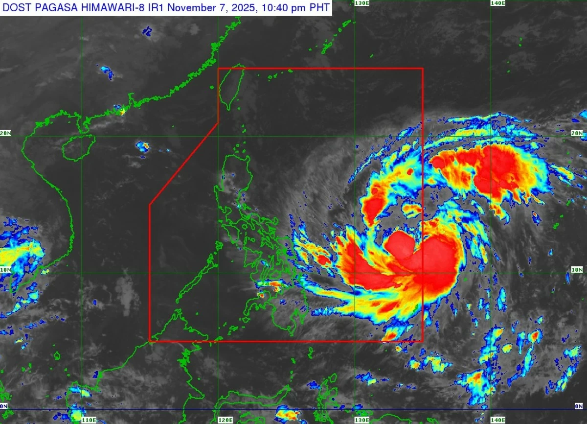
Satellite image of Typhoon Uwan (Fung-wong) (Courtesy of PAGASA)
Tropical cyclone “Uwan” (international name: Fung-wong) entered the Philippine Area of Responsibility (PAR) on Friday evening, Nov. 7, after intensifying into a typhoon over the Philippine Sea, the Philippine Atmospheric, Geophysical and Astronomical Services Administration (PAGASA) said.
PAGASA said Uwan strengthened into a typhoon around 8 p.m. and entered the PAR at 10 p.m.
The cyclone was last spotted 1,045 kilometers east of Eastern Visayas, packing maximum sustained winds of 120 kilometers per hour (kph) near the center and gustiness of up to 150 kph. It was moving west-northwestward at 20 kph.
Uwan is expected to continue strengthening and may reach super typhoon category by Saturday evening, Nov. 8, or early Sunday, Nov. 9, PAGASA said.
“On the track forecast, the center of Uwan may make landfall over the southern portion of Isabela or the northern portion of Aurora on Sunday late evening or Monday early morning,” PAGASA said.
The weather bureau warned that the typhoon may make landfall “at or near its peak intensity.”
After crossing land, Uwan is expected to weaken slightly due to its interaction with the mountainous terrain of Northern Luzon but will likely remain a typhoon as it moves over the West Philippine Sea by Monday morning or afternoon.
Wind signals raised
With Uwan’s entry into the PAR, PAGASA hoisted Tropical Cyclone Wind Signal No. 1 over more areas in Luzon, Visayas, and Mindanao.
Areas under Signal No. 1 may experience strong winds of 39 to 61 kph within 36 hours, which may bring minimal to minor threats to life and property.
Signal No. 1 is in effect over:
* Eastern portion of Isabela (Divilacan, Palanan, Dinapigue, San Mariano, San Guillermo, Echague, Jones, San Agustin)
* Eastern and southern portions of Quirino (Maddela, Nagtipunan)
* Southeastern portion of Nueva Vizcaya (Alfonso Castañeda)
* Aurora
* Southeastern portion of Rizal (Tanay, Pililla, Jala-Jala)
* Eastern portion of Laguna (Luisiana, Mabitac, Liliw, Majayjay, Paete, Pagsanjan, Rizal, Pangil, Santa Maria, Siniloan, Nagcarlan, Cavinti, Kalayaan, Lumban, Magdalena, Victoria, Pakil, Santa Cruz, Pila, and Famy)
* Eastern and southern portions of Quezon (Tagkawayan, Guinayangan, Calauag, Lopez, Buenavista, Catanauan, Mulanay, San Narciso, San Andres, San Francisco, Pitogo, Lucena City, Pagbilao, Infanta, Unisan, General Luna, Plaridel, Quezon, Alabat, Lucban, Sampaloc, Padre Burgos, City of Tayabas, Macalelon, Mauban, General Nakar, Perez, Agdangan, Gumaca, Atimonan, Real, Sariaya, and Candelaria), including Polillo Islands
* Romblon
* Marinduque
* Camarines Norte
* Camarines Sur
* Albay
* Catanduanes
* Sorsogon
* Masbate, including Ticao and Burias Islands
* Northern Samar
* Eastern Samar
* Samar
* Biliran
* Leyte
* Southern Leyte
* Northern and central portions of Cebu (Medellin, Daanbantayan, City of Bogo, Tabogon, San Remigio, Tabuelan, Borbon, Sogod, Tuburan, Catmon, Carmen, Danao City, Compostela, Liloan, Consolacion, Lapu-Lapu City, Mandaue City, Cordova, Asturias, Cebu City, Balamban, City of Talisay, Toledo City, Minglanilla), including Bantayan and Camotes Islands
* Northeastern portion of Bohol (Getafe, Talibon, Buenavista, Trinidad, San Miguel, Ubay, Alicia, Mabini, Bien Unido, Pres. Carlos P. Garcia)
* Northern portion of Negros Occidental (City of Escalante, Toboso, Sagay City, Cadiz City, Calatrava, Manapla, City of Victorias, Enrique B. Magalona, Silay City, City of Talisay)
* Northern portion of Iloilo (Carles, Estancia, Balasan, San Dionisio, Concepcion, Batad, Sara, Ajuy, Barotac Viejo, San Rafael, Lemery)
* Northeastern and western portions of Capiz (President Roxas, Pilar, Panay, Pontevedra, Ma-Ayon, Cuartero, Dumarao, Dao, Panitan, Roxas City, Ivisan, Sigma, Sapi-An, Mambusao, Dumalag, Jamindan)
* Aklan
* Dinagat Islands
* Surigao del Norte
“The highest wind signal that will likely be hoisted throughout its passage is Wind Signal No. 5,” PAGASA said.
Heavy rainfall outlook
From Saturday evening to Sunday evening, Uwan will bring intense to torrential rains exceeding 200 millimeters over Camarines Norte, Camarines Sur, Catanduanes, and Albay.
Heavy to intense rains of 100 to 200 millimeters are expected over Cagayan, Isabela, Quirino, Aurora, Quezon, Sorsogon, Masbate, Northern Samar, Samar, and Eastern Samar.
Moderate to heavy rains of 50 to 100 millimeters may be experienced in Apayao, Kalinga, Mountain Province, Ifugao, Abra, Benguet, Pangasinan, Nueva Vizcaya, Nueva Ecija, Tarlac, Pampanga, Bulacan, Rizal, Laguna, Marinduque, Romblon, Biliran, and Leyte.
From Sunday evening to Monday evening, more than 200 millimeters of rain may drench Aurora, Nueva Ecija, Cagayan, Isabela, Quirino, Nueva Vizcaya, Apayao, Kalinga, Abra, Mountain Province, Ifugao, Benguet, Ilocos Norte, Ilocos Sur, La Union, Zambales, Tarlac, and Pangasinan.
Meanwhile, 100 to 200 millimeters are expected in Metro Manila, Bataan, Pampanga, Bulacan, Cavite, Laguna, Batangas, Rizal, Quezon, and Occidental Mindoro, while 50 to 100 millimeters may fall over Batanes, Oriental Mindoro, Marinduque, Romblon, Camarines Norte, Camarines Sur, Aklan, and Antique.
PAGASA warned residents in these areas to be alert for possible flooding and rain-induced landslides, especially in low-lying and mountainous areas.