


Manila Bulletin
 Philippines
National
Prepare now for 'extremely dangerous' cyclone approaching Philippines, PAGASA warns
Philippines
National
Prepare now for 'extremely dangerous' cyclone approaching Philippines, PAGASA warns
Philippines
National
Prepare now for 'extremely dangerous' cyclone approaching Philippines, PAGASA warns
Prepare now for 'extremely dangerous' cyclone approaching Philippines, PAGASA warns
Published Nov 7, 2025 02:13 pm


PAGASA
The Philippine Atmospheric, Geophysical and Astronomical Services Administration (PAGASA) on Friday, Nov. 7, urged Filipinos to take immediate precautions as the severe tropical storm, internationally known as “Fung-wong,” moves toward the Philippine Area of Responsibility (PAR) and could intensify rapidly.
Once inside the PAR, the storm will be given the local name “Uwan.”
“This is a very intense and enormous tropical cyclone that is about to enter the PAR. It is dangerous and could bring destructive winds, intense to torrential rains, and dangerous storm surges, conditions that can lead to widespread flooding, landslides, and severe coastal inundation in vulnerable areas. We cannot emphasize enough, now is the time to prepare,” PAGASA Administrator Dr. Nathaniel Servando said in a press conference.
“Super Typhoon Uwan is extremely dangerous, and early preparation and cooperation will make a crucial difference in keeping our communities safe,” he added.
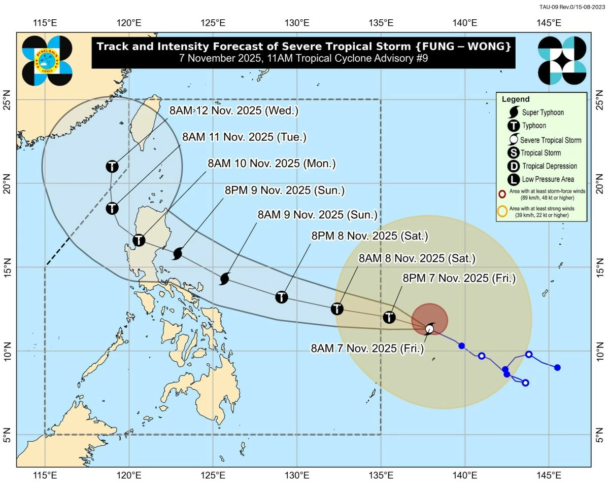
As of 10 a.m., the center of Fung-wong was located 1,325 kilometers east of Visayas, moving west-northwest at 20 kilometers per hour (kph) with maximum sustained winds of 100 kph near the center and gusts of up to 125 kph.
PAGASA weather specialist Benison Estareja said the tropical cyclone spans roughly 1,400 to 1,450 kilometers in diameter, equivalent to the distance from Batanes to northern Zamboanga.
“We have to emphasize that this is a very strong storm. This means that as early as Saturday evening (Nov. 8), the strong gusts of wind will already be felt in the Bicol Region, Eastern Visayas, and even in nearby areas of Caraga, Central Visayas, as well as parts of Mimaropa and Calabarzon,” he said.
Fung-wong is expected to enter the PAR late Friday evening or by Saturday morning, reaching typhoon strength with winds of 120 to 130 kph.
The cyclone may undergo rapid intensification over the Philippine Sea and reach maximum winds of 185 to 195 kph, becoming a super typhoon, as it nears Luzon by Sunday, Nov. 9.
The cyclone is projected to approach mainland Luzon late Sunday or early Monday, with possible landfall in Aurora or Isabela, before moving toward the West Philippine Sea by Monday morning, Nov. 10.
Estareja said wind signals may be raised as early as Friday afternoon over portions of Southern Luzon, Eastern Visayas, and Caraga Region, with the highest possible warning being Signal No. 5 during the passage of the weather disturbance.
“Deteriorating conditions” may continue Sunday through Tuesday, Nov. 11, with potentially life-threatening winds over Northern and parts of Central Luzon.
PAGASA also warned of heavy rainfall in the coming days.
From Saturday noon to Sunday noon, Catanduanes could receive more than 200 millimeters of rain (intense to torrential), while Northern Samar, Eastern Samar, Sorsogon, Albay, Camarines Sur, and Camarines Norte are expected to experience 100 to 200 millimeters of rain (heavy to intense.
Fifty to 100 millimeters of rainfall (moderate to heavy) is expected in Samar, Biliran, Leyte, Masbate, Quezon, Marinduque, Romblon, Aurora, Quirino, Isabela, and Cagayan.
From Sunday noon to Monday noon, Aurora, Nueva Ecija, Cagayan, Isabela, Quirino, Nueva Vizcaya, Apayao, Kalinga, Abra, Mountain Province, Ifugao, Benguet, Ilocos Norte, Ilocos Sur, La Union, and Pangasinan could receive more than 200 millimeters of rain.
Metro Manila, Quezon, Rizal, Laguna, Cavite, Camarines Norte, Camarines Sur, Catanduanes, Zambales, Bataan, Tarlac, Pampanga, and Bulacan may receive 100 to 200 millimeters, while Batanes, Batangas, Occidental Mindoro, Oriental Mindoro, Marinduque, Romblon, Albay, Sorsogon, Masbate, Aklan, Antique, and Northern Samar are expected to get 50 to 100 millimeters.
Moderate to rough seas are expected over the northern and eastern seaboards of Luzon, Visayas, and parts of Mindanao by Friday or Saturday, spreading to western and southern coasts by Sunday.
Hazardous sea conditions, including very rough and high seas, may affect most of Luzon and the eastern seaboards of Visayas and Mindanao from Sunday onward, with gale warnings likely.
PAGASA said storm surges could impact coastal areas not only directly in the cyclone’s path but also nearby communities, including parts of Calabarzon, Cagayan Valley, and Ilocos Region.