


PAGASA raises Signal No. 1 even before 'Uwan' enters PAR
Published Nov 7, 2025 06:02 pm


PAGASA
The Philippine Atmospheric, Geophysical and Astronomical Services Administration (PAGASA) on Friday afternoon, Nov. 7 raised Tropical Cyclone Wind Signal No. 1 over 21 areas even before Severe Tropical Storm Fung-wong, now locally named “Uwan,” enters the Philippine Area of Responsibility (PAR).
As of 4 p.m., the center of Uwan was located 1,175 kilometers east of Eastern Visayas. It has maximum sustained winds of 110 kilometers per hour (kph) near the center and gustiness of up to 135 kph, while moving westward at 25 kph.
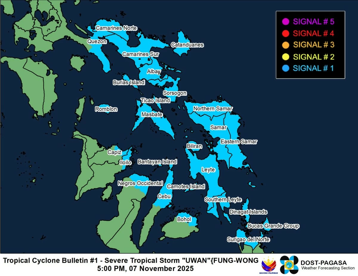
In its Tropical Cyclone Bulletin No. 1 issued at 5 p.m., PAGASA said Signal No. 1 is in effect over the southeastern portion of Quezon (Tagkawayan, Guinayangan, Calauag, Lopez, Buenavista, Catanauan, Mulanay, San Narciso, San Andres, San Francisco), eastern portion of Romblon (Cajidiocan, San Fernando, Magdiwang), Camarines Norte, Camarines Sur, Catanduanes, Albay, Sorsogon, Masbate, Northern Samar, Eastern Samar, Samar, Biliran, Leyte, Southern Leyte, northern and central portions of Cebu (Medellin, Daanbantayan, City of Bogo, Tabogon, San Remigio, Tabuelan, Borbon, Sogod, Tuburan, Catmon, Carmen, Danao City, Compostela, Liloan, Consolacion, Lapu-Lapu City, Mandaue City, Cordova, Asturias, Cebu City, Balamban, City of Talisay, Toledo City, Minglanilla) including Bantayan and Camotes Islands, northeastern portion of Bohol (Getafe, Talibon, Buenavista, Trinidad, San Miguel, Ubay, Alicia, Mabini, Bien Unido, President Carlos P. Garcia), northern portion of Negros Occidental (City of Escalante, Toboso, Sagay City, Cadiz City, Calatrava, Manapla). northeastern portion of Capiz (President Roxas, Pilar, Panay, Pontevedra), northeastern portion of Iloilo (Carles, Estancia, Balasan, San Dionisio, Concepcion, Batad, Sara, Ajuy), Dinagat Islands, and Surigao del Norte.
PAGASA said areas under Signal No. 1 may experience strong winds of 39 to 61 kph within 36 hours, which may bring minimal to minor threats to life and property.
Considering Uwan’s vast circulation, PAGASA raised wind signals even before the storm’s entry into the PAR, as its outer bands may begin affecting parts of the Visayas and Bicol within the 36-hour lead time.
“The highest wind signal that will likely be hoisted throughout its passage is Wind Signal No. 5,” PAGASA said, adding that Uwan may intensify into a super typhoon prior to landfall.
Uwan may move generally westward in the next 24 hours before turning west-northwestward for most of the forecast period.
Based on the latest forecast track, the storm may enter the PAR between Friday evening and Saturday morning, Nov. 8.
It is expected to make landfall over the southern portion of Isabela or the northern portion of Aurora between Sunday evening, Nov. 9, and Monday morning, Nov. 10.
After landfall, Uwan will cross the mountainous terrain of Northern Luzon and may emerge over the West Philippine Sea by Monday morning or afternoon.
In terms of intensity, Uwan may rapidly strengthen into a typhoon within 24 hours and reach super typhoon category between Saturday evening and Sunday morning.
“It may make landfall at or near its peak intensity,” PAGASA said.
While the storm will weaken after crossing Luzon, the weather bureau said it is likely to remain at typhoon strength throughout its passage over the country.