ADVERTISEMENT

PAGASA: 'Tino' makes 8th landfall over El Nido, Palawan

Published Nov 5, 2025 08:45 am
PAGASA
PAGASA
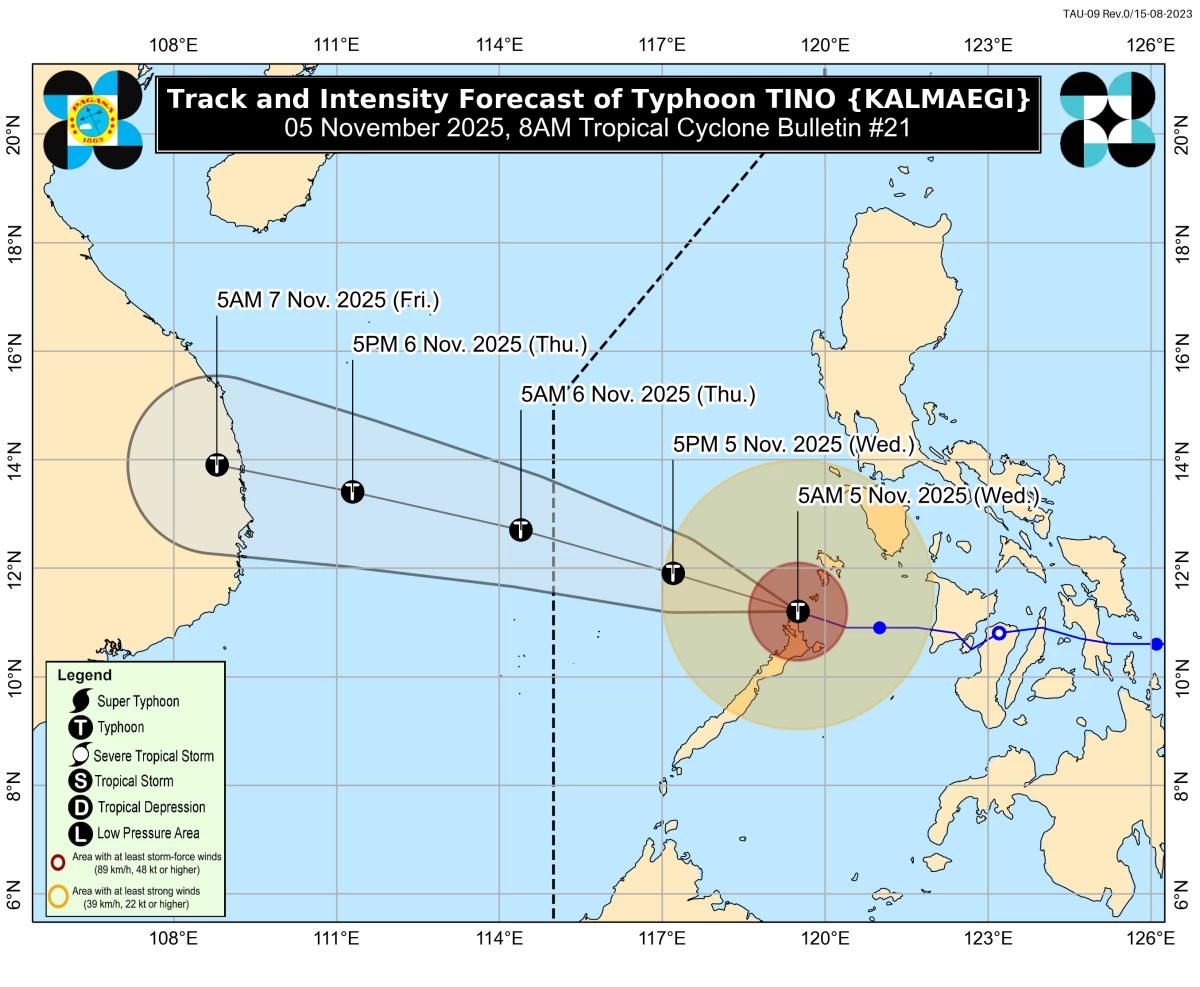
Typhoon Tino (international name: Kalmaegi) has made a total of eight landfalls during its passage across the Philippines, the Philippine Atmospheric, Geophysical and Astronomical Services Administration (PAGASA) reported on Wednesday, Nov. 5.
PAGASA said Tino made its eighth landfall over El Nido, Palawan at 4:40 a.m. on Wednesday.
The previous landfalls occurred as follows: Silago, Southern Leyte at 12 a.m. on Nov. 4; Borbon, Cebu at 5:10 a.m. on Nov. 4; Sagay City, Negros Occidental at 6:40 a.m. on Nov. 4; San Lorenzo, Guimaras at 11:10 a.m. on Nov. 4; Iloilo City, Iloilo at 1:20 p.m. on Nov. 4; Cuyo Islands, Palawan at 7:30 p.m. on Nov. 4; and Batas Island, Taytay, Palawan at 4:10 a.m. on Nov. 5.
Tino is expected to continue moving west-northwestward over the West Philippine Sea and exit the Philippine Area of Responsibility (PAR) by Wednesday evening or Thursday morning, Nov. 6.
PAGASA said the typhoon, although gradually weakening since its first landfall, remains strong, with maximum sustained winds of 120 kilometers per hour near the center and gusts of up to 165 kph.
Signal No. 4 remains hoisted over the northernmost portion of Palawan (El Nido, Taytay, Araceli) and Calamian Islands, while Signal No. 3 is in effect over northern Palawan (Dumaran, San Vicente, Roxas) and Cuyo Islands.
Signal No. 2 continues over southern Occidental Mindoro (Magsaysay, San Jose, Rizal, Calintaan) and central Palawan (Puerto Princesa City), including Kalayaan Islands, and Signal No. 1 over the rest of Occidental Mindoro, including Lubang Islands, Oriental Mindoro, southwestern Romblon (Santa Fe, Looc, San Jose, Ferrol), and southern Palawan (Aborlan, Quezon, Narra, Sofronio Española), including Cagayancillo Islands, Antique, including Caluya Islands, and northwestern Aklan (Buruanga, Malay, Nabas).
Meanwhile, PAGASA continues to monitor a tropical depression outside the PAR.
As of 3 a.m., it was located 1,830 kilometers east of southern Mindanao, with maximum sustained winds of 55 kph and gustiness of up to 70 kph, moving south-southwestward at 20 kph.
According to PAGASA weather specialist Loriedin de la Cruz-Galicia, the weather disturbance is expected to intensify while over the ocean and could reach typhoon strength before entering the PAR.
It may also become a super typhoon while inside the PAR
The tropical cyclone may enter the PAR between Friday evening, Nov. 7, and Saturday morning, Nov. 8, and will be named “Uwan” upon entry.
De la Cruz-Galicia advised the public to remain vigilant as the system’s track and intensity may still change due to its distance and the high level of uncertainty.

Related Tags

PAGASA TINO TYPHOON TINO UWAN SIGNAL NO. 4 EIGHTH LANDFALL SUPER TYPHOON
ADVERTISEMENT
.most-popular .layout-ratio{ padding-bottom: 79.13%; } @media (min-width: 768px) and (max-width: 1024px) { .widget-title { font-size: 15px !important; } }

{{ articles_filter_1561_widget.title }}

.most-popular .layout-ratio{ padding-bottom: 79.13%; } @media (min-width: 768px) and (max-width: 1024px) { .widget-title { font-size: 15px !important; } }

{{ articles_filter_1562_widget.title }}

.most-popular .layout-ratio{ padding-bottom: 79.13%; } @media (min-width: 768px) and (max-width: 1024px) { .widget-title { font-size: 15px !important; } }

{{ articles_filter_1563_widget.title }}

{{ articles_filter_1564_widget.title }}

.mb-article-details { position: relative; } .mb-article-details .article-body-preview, .mb-article-details .article-body-summary{ font-size: 17px; line-height: 30px; font-family: "Libre Caslon Text", serif; color: #000; } .mb-article-details .article-body-preview iframe , .mb-article-details .article-body-summary iframe{ width: 100%; margin: auto; } .read-more-background { background: linear-gradient(180deg, color(display-p3 1.000 1.000 1.000 / 0) 13.75%, color(display-p3 1.000 1.000 1.000 / 0.8) 30.79%, color(display-p3 1.000 1.000 1.000) 72.5%); position: absolute; height: 200px; width: 100%; bottom: 0; display: flex; justify-content: center; align-items: center; padding: 0; } .read-more-background a{ color: #000; } .read-more-btn { padding: 17px 45px; font-family: Inter; font-weight: 700; font-size: 18px; line-height: 16px; text-align: center; vertical-align: middle; border: 1px solid black; background-color: white; } .hidden { display: none; }
function initializeAllSwipers() { // Get all hidden inputs with cms_article_id document.querySelectorAll('[id^="cms_article_id_"]').forEach(function (input) { const cmsArticleId = input.value; const articleSelector = '#article-' + cmsArticleId + ' .body_images'; const swiperElement = document.querySelector(articleSelector); if (swiperElement && !swiperElement.classList.contains('swiper-initialized')) { new Swiper(articleSelector, { loop: true, pagination: false, navigation: { nextEl: '#article-' + cmsArticleId + ' .swiper-button-next', prevEl: '#article-' + cmsArticleId + ' .swiper-button-prev', }, }); } }); } setTimeout(initializeAllSwipers, 3000); const intersectionObserver = new IntersectionObserver( (entries) => { entries.forEach((entry) => { if (entry.isIntersecting) { const newUrl = entry.target.getAttribute("data-url"); if (newUrl) { history.pushState(null, null, newUrl); let article = entry.target; // Extract metadata const author = article.querySelector('.author-section').textContent.replace('By', '').trim(); const section = article.querySelector('.section-info ').textContent.replace(' ', ' '); const title = article.querySelector('.article-title h1').textContent; // Parse URL for Chartbeat path format const parsedUrl = new URL(newUrl, window.location.origin); const cleanUrl = parsedUrl.host + parsedUrl.pathname; // Update Chartbeat configuration if (typeof window._sf_async_config !== 'undefined') { window._sf_async_config.path = cleanUrl; window._sf_async_config.sections = section; window._sf_async_config.authors = author; } // Track virtual page view with Chartbeat if (typeof pSUPERFLY !== 'undefined' && typeof pSUPERFLY.virtualPage === 'function') { try { pSUPERFLY.virtualPage({ path: cleanUrl, title: title, sections: section, authors: author }); } catch (error) { console.error('ping error', error); } } // Optional: Update document title if (title && title !== document.title) { document.title = title; } } } }); }, { threshold: 0.1 } ); function showArticleBody(button) { const article = button.closest("article"); const summary = article.querySelector(".article-body-summary"); const body = article.querySelector(".article-body-preview"); const readMoreSection = article.querySelector(".read-more-background"); // Hide summary and read-more section summary.style.display = "none"; readMoreSection.style.display = "none"; // Show the full article body body.classList.remove("hidden"); } document.addEventListener("DOMContentLoaded", () => { let loadCount = 0; // Track how many times articles are loaded const offset = [1, 2, 3, 4, 5, 6, 7, 8, 9, 10]; // Offset values const currentUrl = window.location.pathname.substring(1); let isLoading = false; // Prevent multiple calls if (!currentUrl) { console.log("Current URL is invalid."); return; } const sentinel = document.getElementById("load-more-sentinel"); if (!sentinel) { console.log("Sentinel element not found."); return; } function isSentinelVisible() { const rect = sentinel.getBoundingClientRect(); return ( rect.top < window.innerHeight && rect.bottom >= 0 ); } function onScroll() { if (isLoading) return; if (isSentinelVisible()) { if (loadCount >= offset.length) { console.log("Maximum load attempts reached."); window.removeEventListener("scroll", onScroll); return; } isLoading = true; const currentOffset = offset[loadCount]; window.loadMoreItems().then(() => { let article = document.querySelector('#widget_1690 > div:nth-last-of-type(2) article'); intersectionObserver.observe(article) loadCount++; }).catch(error => { console.error("Error loading more items:", error); }).finally(() => { isLoading = false; }); } } window.addEventListener("scroll", onScroll); });

Sign up by email to receive news.