


Manila Bulletin
 Philippines
National
'Life-threatening conditions' continue over Negros Island as Typhoon Tino traverses Visayas
Philippines
National
'Life-threatening conditions' continue over Negros Island as Typhoon Tino traverses Visayas
Philippines
National
'Life-threatening conditions' continue over Negros Island as Typhoon Tino traverses Visayas
'Life-threatening conditions' continue over Negros Island as Typhoon Tino traverses Visayas
Published Nov 4, 2025 08:41 am


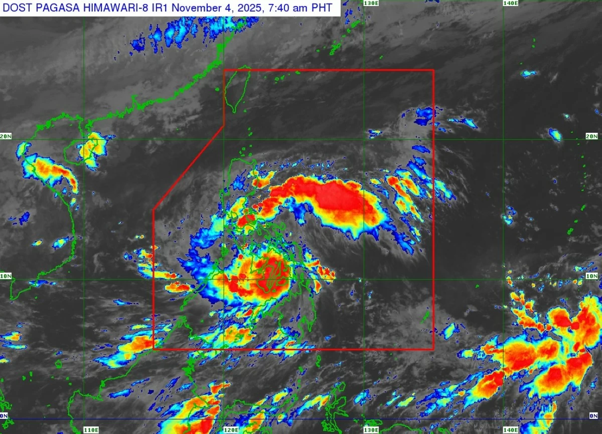
Satellite image of Typhoon Tino (Kalmaegi) (Courtesy of PAGASA)
Typhoon Tino (international name: Kalmaegi) continues to bring life-threatening conditions over Negros Island as it moves across the Visayas, the Philippine Atmospheric, Geophysical and Astronomical Services Administration (PAGASA) said in its 8 a.m. bulletin on Tuesday, Nov. 4.
PAGASA weather specialist Chenel Dominguez said Tino has made two landfalls: at 12 a.m. over Silago, Southern Leyte, and at 5:10 a.m. over Borbon, Cebu.
“Tino has passed close to the Camotes Islands and is forecast to traverse the Visayas and northern Palawan until it emerges over the West Philippine Sea by tomorrow morning (Nov. 5). It is expected to exit the Philippine Area of Responsibility by tomorrow evening or early Thursday (Nov. 6),” PAGASA said.
As of 7 a.m., the typhoon’s eye was located over Sagay City, Negros Occidental, moving west-northwest at 25 kilometers per hour (kph).
Tino remains a strong tropical cyclone, with maximum sustained winds of 150 kph near the center and gusts of up to 205 kph.
“Due to interaction with the terrain, Tino may slightly weaken while crossing the Visayas, but it is expected to remain at typhoon strength throughout its passage,” PAGASA said.
Tropical cyclone wind signals remain in effect across several areas.
Signal No. 4 remains in effect over the western portion of Leyte (Palompon, Isabel, Merida), northern portion of Cebu (Lapu-Lapu City, Cordova, Mandaue City, Cebu City, Balamban, Asturias, Danao City, Compostela, Liloan, Consolacion, Borbon, Carmen, Tuburan, Catmon, Sogod, Tabuelan, Tabogon, San Remigio, City of Bogo, Toledo City, City of Talisay, Minglanilla, Medellin, Daanbantayan), including Camotes Islands and Bantayan Islands; northernmost portion of Negros Oriental (Vallehermoso, Canlaon City); northern portion of Negros Occidental (San Carlos City, Salvador Benedicto, Calatrava, Toboso, City of Escalante, Sagay City, Cadiz City, Manapla, City of Victorias, Enrique B. Magalona, Silay City, City of Talisay, Bacolod City, Murcia, Bago City, Pulupandan, Valladolid, La Carlota City, San Enrique, Pontevedra, La Castellana); Guimaras; Capiz; Iloilo; central and southern portions of Antique (Patnongon, Sibalom, Barbaza, Valderrama, Hamtic, San Jose, Bugasong, Culasi, Tibiao, Anini-Y, San Remigio, Belison, Tobias Fornier, Laua-An); and southern portion of Aklan (Libacao, New Washington, Banga, Altavas, Madalag, Balete, Batan).
Signal No. 3 is hoisted over the southwestern portion of Masbate (Balud), northernmost portion of Palawan (El Nido, Taytay, Dumaran, Araceli), including Calamian Islands and Cuyo Islands; the rest of Leyte; Biliran; northern portion of Bohol (Ubay, Pres. Carlos P. Garcia, Trinidad, San Miguel, Bien Unido, Talibon, Getafe, Buenavista, Inabanga, Danao, Dagohoy); central portion of Cebu (Sibonga, City of Carcar, San Fernando, Aloguinsan, Pinamungahan, Barili, Dumanjug, Argao, Alcantara, Moalboal, Ronda, City of Naga); northern portion of Negros Oriental (City of Guihulngan, La Libertad, Jimalalud); central portion of Negros Occidental (Hinigaran, Moises Padilla, Isabela, Binalbagan); the rest of Aklan; and the rest of Antique, including Caluya Islands.
Signal No. 2 is in effect over the western portion of Masbate (Esperanza, Pio V. Corpuz, Placer, Cawayan, Milagros, Mandaon); the southern portion of Oriental Mindoro (Bulalacao, Mansalay, Roxas, Bongabong); southern portion of Occidental Mindoro (Magsaysay, San Jose, Rizal, Calintaan); Romblon; northern portion of Palawan (San Vicente, Roxas); western and southern portions of Samar (San Sebastian, Santa Rita, Villareal, Zumarraga, Pinabacdao, Talalora, Jiabong, City of Catbalogan, Motiong, Calbiga, Daram, Paranas, Basey, Hinabangan, Santo Niño, Almagro, Tarangnan, Marabut, San Jorge, Gandara, Pagsanghan, Santa Margarita, Tagapul-An, Calbayog City); the rest of Cebu; central portion of Negros Oriental (Tayasan, Manjuyod, Bais City, Mabinay, Bindoy, Ayungon, City of Tanjay, Pamplona, Amlan, San Jose); the rest of Negros Occidental; Southern Leyte; and the rest of Bohol.
Signal No. 1 remains hoisted over Sorsogon; the rest of Masbate, including Ticao and Burias islands; Albay; the rest of Oriental Mindoro; northern and central portions of Occidental Mindoro (Sablayan, Santa Cruz, Abra de Ilog, Mamburao, Paluan); southern portion of Quezon (San Francisco, San Andres); southern portion of Marinduque (Torrijos, Buenavista, Gasan, Boac); central portion of Palawan (Puerto Princesa City), including Cagayancillo Islands; Northern Samar; Eastern Samar; the rest of Samar; the rest of Negros Oriental; Siquijor; Dinagat Islands; northern portion of Surigao del Norte (Surigao City, San Francisco, Malimono, Mainit, Sison, Tagana-An, Placer, Tubod, Bacuag); and Camiguin.
PAGASA also warned of continuous heavy to torrential rains across parts of the country due to Typhoon Tino and the shear line, a weather system formed by the collision of cold winds from the northeast monsoon (amihan) and warm easterly winds.
On Tuesday, more than 200 millimeters of rainfall (intense to torrential) may affect Eastern Samar, Southern Leyte, Leyte, Dinagat Islands, Cebu, Negros Occidental, Surigao del Norte, Aklan, Iloilo, Guimaras, and Capiz.
Areas that may receive 100–200 millimeters of rainfall (heavy to intense) are Northern Samar, Oriental Mindoro, Sorsogon, Biliran, Samar, Bohol, Camiguin, Antique, Siquijor, Negros Oriental, Romblon, Masbate, Misamis Oriental, and Agusan del Norte.
Moderate to heavy rains (50–100 millimeters) are expected in Surigao del Sur, Batangas, Catanduanes, Albay, Palawan, Marinduque, Occidental Mindoro, Maguindanao del Norte and Sur, Sultan Kudarat, Misamis Occidental, Zamboanga del Norte, Lanao del Norte, Agusan del Sur, Bukidnon, Sarangani, and Lanao del Sur.
On Wednesday, rainfall of over 200 millimeters is forecast for Palawan and Antique; 100–200 millimeters for Romblon, Oriental Mindoro, Cebu, Negros Occidental, Guimaras, Iloilo, Aklan, and Capiz; and 50–100 millimeters for Occidental Mindoro, Marinduque, Misamis Oriental, Camiguin, Zamboanga del Norte, Batangas, Lanao del Norte, Southern Leyte, Leyte, Samar, Biliran, Negros Oriental, Siquijor, Bohol, Misamis Occidental, and Masbate.
Moderate to heavy rains due to the shear line are also expected in Cagayan, Isabela, Aurora, Quezon, Camarines Norte, and Camarines Sur on Tuesday.
On Wednesday, Aurora and Quezon may experience heavy to intense rainfall, while Isabela, Camarines Norte, and Camarines Sur are forecast to receive moderate to heavy rains.
On Thursday, moderate to heavy rainfall is expected to continue over Aurora and Quezon.
PAGASA advised residents in all affected areas to remain alert for possible flooding and landslides.