


Manila Bulletin
 Philippines
National
PAGASA: 'Tino' on path similar to 'Yolanda', may unleash destructive winds, torrential rains
Philippines
National
PAGASA: 'Tino' on path similar to 'Yolanda', may unleash destructive winds, torrential rains
Philippines
National
PAGASA: 'Tino' on path similar to 'Yolanda', may unleash destructive winds, torrential rains
PAGASA: 'Tino' on path similar to 'Yolanda', may unleash destructive winds, torrential rains
System intensifies into typhoon ahead of Nov. 3 or 4 landfall
Published Nov 3, 2025 11:56 am
|
Updated Nov 3, 2025 01:43 pm


At A Glance
- Typhoon Tino (international name: Kalmaegi) intensified on Monday, Nov. 3, as it moved closer to the Visayas on a path similar to Super Typhoon Yolanda (2013).
- It packed maximum sustained winds of 120 kph and gusts of up to 150 kph, with further strengthening possible before its expected landfall over Eastern Visayas late Monday or early Tuesday, Nov. 4.
- PAGASA warned of destructive winds, torrential rains, and flooding across parts of the Visayas and Northern Mindanao.
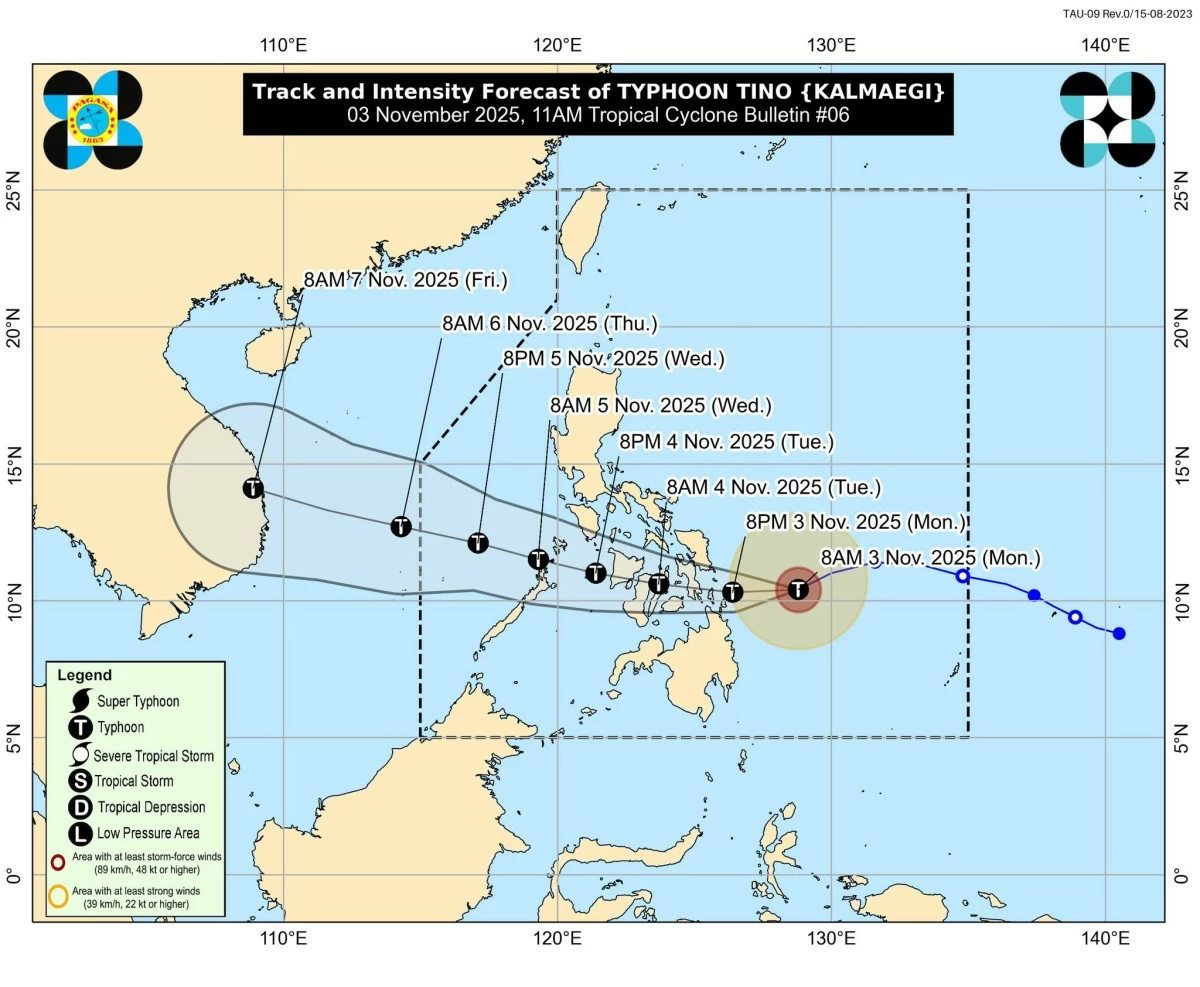
Typhoon Tino (Kalmaegi) forecast track and intensity (Courtesy of PAGASA)
The Philippine Atmospheric, Geophysical and Astronomical Services Administration (PAGASA) said tropical cyclone “Tino” (international name: Kalmaegi) intensified from a severe tropical storm into a typhoon on Monday, Nov. 3, as it continued to approach the Visayas on a track similar to that of Super Typhoon Yolanda (Haiyan) in 2013.
As of 10 a.m., the center of Typhoon Tino was located 285 kilometers east-southeast of Guiuan, Eastern Samar.
It was packing maximum sustained winds of 120 kilometers per hour (kph) near the center and gustiness of up to 150 kph while moving west-southwestward at 25 kph.
PAGASA said Tino may continue to intensify before its expected landfall on Monday evening or early Tuesday, Nov. 4, possibly over the southern portion of Eastern Samar, Leyte, Southern Leyte, or Dinagat Islands.
“Tino is forecast make its initial landfall at or near peak intensity, currently forecasted around 150-165 kph maximum winds with higher gustiness. Rapid intensification within the next 24 hours is likely,” it said.
“The possibility of reaching super typhoon category is not ruled out based on alternate scenarios and climatological data,” it added.
The warm sea surface temperatures and favorable atmospheric conditions could further fuel its intensification, PAGASA’s Weather Division chief Jun Galang said in a press conference on Monday.
He also noted that Tino’s projected path closely resembles that of Yolanda, although in terms of intensity it remains weaker at this stage.
“Almost similar sa track ni Yolanda at hindi natin inaalis yung possibility na maging destructive din ito dahil patuloy pa rin siyang lumalakas (It’s almost similar to Yolanda’s track, and we’re not ruling out the possibility of it becoming destructive as it continues to strengthen),” Galang said.
He explained that warm ocean waters and the prevailing weather pattern brought by the developing La Niña may further enhance the typhoon’s strength and rainfall potential.
After its initial landfall, PAGASA weather specialist Grace Castañeda said Tino is expected to cross parts of the Visayas between Tuesday morning and afternoon, likely passing near Camotes Island, northern Cebu, Negros Occidental, and Iloilo before moving toward the Sulu Sea and northern Palawan by late Tuesday or early Wednesday, Nov. 5.
Castañeda said Metro Manila is not expected to experience strong winds or prolonged heavy rains, though scattered rain showers may occur by Tuesday or Wednesday as the typhoon’s trough and the shear line extend northward.
Heightened warnings
PAGASA Administrator Dr. Nathaniel Servando said the agency continues to issue timely warnings as Tino poses multiple hazards, including strong winds, heavy rainfall, flooding, landslides, and possible storm surges in coastal communities.
“Inaasahan natin na tataas pa ang wind signals habang papalapit ang Bagyong Tino. Pinapayuhan natin ang mga residente, lalo na sa mga lugar na madalas bahain o gumuho, na maging alerto at sumunod sa mga paalala ng local disaster officials (We expect higher wind signals to be raised as Tino moves closer. We advise residents, especially those in flood- and landslide-prone areas, to stay alert and follow the advisories of local disaster officials),” Servando said.
He also urged those in high-risk communities to take precautionary action.
“Kung maaari, ay lumikas na nang mas maaga, lalo na sa mga direktang tatamaan at alam nilang sila ay nasa hazard-prone area (If possible, evacuate early, especially for those directly in the typhoon’s path or living in hazard-prone areas),” he added.
Servando warned that La Niña conditions may enhance Tino’s rainfall, increasing the likelihood of flooding and landslides, particularly in Eastern Visayas and Northern Mindanao.
Heavy rainfall outlook
From Monday until Tuesday noon, intense to torrential rains (more than 200 millimeters) are expected over Eastern Samar, Southern Leyte, Leyte, and Dinagat Islands.
Heavy to intense rains (100 to 200 millimeters) are forecast over Surigao del Norte, Northern Samar, Sorsogon, Biliran, Samar, Cebu, Bohol, Camiguin, and Agusan del Norte, while moderate to heavy rains (50 to 100 millimeters) may affect Misamis Oriental, Surigao del Sur, Negros Occidental, Siquijor, Negros Oriental, Iloilo, Capiz, Aklan, Antique, Catanduanes, Romblon, Albay, Masbate, Palawan, Marinduque, Oriental Mindoro, Maguindanao del Norte, Maguindanao del Sur, Sultan Kudarat, Misamis Occidental, Zamboanga del Norte, Lanao del Norte, Agusan del Sur, Bukidnon, Sarangani, Lanao del Sur, and Guimaras.
Between Tuesday noon and Wednesday noon, intense to torrential rainfall is expected over Negros Occidental, Aklan, Guimaras, Iloilo, Capiz, Antique, and Cebu.
Heavy to intense rains will also affect Eastern Samar, Southern Leyte, Leyte, Samar, Biliran, Bohol, Dinagat Islands, Surigao del Norte, Romblon, Siquijor, Oriental Mindoro, Masbate, Negros Oriental, and Palawan.
Meanwhile, moderate to heavy rains may persist over Catanduanes, Albay, Sorsogon, Northern Samar, Occidental Mindoro, Marinduque, Misamis Oriental, Camiguin, Batangas, Agusan del Norte, Lanao del Norte, Misamis Occidental, and Zamboanga del Norte.
From Wednesday noon to Thursday noon, Nov. 6, moderate to heavy rains (50 to 100 millimeters) are likely over Palawan.
At the same time, the shear line will bring moderate to heavy rainfall over Isabela, Aurora, Quezon, Camarines Norte, and Camarines Sur from Monday through Thursday.
Tropical cyclone wind signals
PAGASA said the highest possible tropical cyclone wind signal that may be hoisted during Tino’s passage is Signal No. 4.
As of 11 a.m. on Monday, Signal No. 3 was raised over:
* Southern portion of Eastern Samar (Guiuan, Salcedo, Mercedes, Lawaan, Balangiga, Giporlos, Quinapondan)
* Southern portion of Samar (Marabut)
* Central and southern portions of Leyte (Tanauan, Palo, Tabontabon, Isabel, Merida, Palompon, Ormoc City, Dagami, Pastrana, Burauen, Albuera, Macarthur, La Paz, Mayorga, Dulag, Julita, Tolosa, Abuyog, Javier, City of Baybay, Mahaplag, Inopacan, Hilongos, Hindang, Bato, Matalom)
* Southern Leyte
* Camotes Islands
* Eastern portion of Bohol (Jagna, Duero, Guindulman, Anda, Candijay, Alicia, Mabini, Ubay, San Miguel, Trinidad, Talibon, Bien Unido)
* Dinagat Islands
* Northern portion of Surigao del Norte (Surigao City, San Francisco, Tagana-An, Placer, Sison), including Siargao and Bucas Grande Islands
Signal No. 2 was hoisted over:
* Southern portion of Masbate (Esperanza, Pio V. Corpuz, Placer)
* Central portion of Eastern Samar (Can-avid, Borongan City, Taft, Llorente, Maydolong, Balangkayan, Sulat, San Julian, General MacArthur, Hernani)
* Central portion of Samar (San Sebastian, Santa Rita, Villareal, Zumarraga, Pinabacdao, Talalora, Jiabong, Catbalogan City, Motiong, Calbiga, Daram, Paranas, Basey, Hinabangan, Santo Niño, Almagro, Tarangnan)
* Rest of Leyte
* Biliran
* Rest of Bohol
* Rest of Cebu
* Northern and central portions of Negros Oriental (Tayasan, Manjuyod, Tanjay City, Bais City, Mabinay, Bindoy, Ayungon, Jimalalud, Guihulngan City, La Libertad, Canlaon City, Vallehermoso)
* Northern and central portions of Negros Occidental (Escalante City, Toboso, Calatrava, Salvador Benedicto, Himamaylan City, Kabankalan City, Ilog, Binalbagan, Isabela, Moises Padilla, San Carlos City, La Castellana, Hinigaran, Pontevedra, La Carlota City, San Enrique, Valladolid, Pulupandan, Bago City, Murcia, Bacolod City, Talisay City, Victorias City, Enrique B. Magalona, Silay City, Cadiz City, Manapla, Sagay City)
* Guimaras
* Eastern portion of Capiz (Pilar, President Roxas, Pontevedra, Panay, Dumarao, Cuartero, Maayon, Panitan, Roxas City, Ivisan, Sigma, Dao, Dumalag)
* Northern and eastern portions of Iloilo (Carles, Oton, San Miguel, Cabatuan, Badiangan, Calinog, Bingawan, Passi City, Dueñas, Mina, Iloilo City, Pavia, Santa Barbara, Zarraga, Pototan, New Lucena, Leganes, Barotac Nuevo, Dumangas, Dingle, San Enrique, Anilao, Banate, Barotac Viejo, San Rafael, Lemery, Ajuy, Concepcion, Sara, San Dionisio, Batad, Balasan, Estancia)
* Rest of Surigao del Norte, the northern portion of Surigao del Sur (Carrascal, Cantilan, Madrid, Carmen, Lanuza, Cortes)
* Northeastern portion of Agusan del Norte (Kitcharao, Jabonga, Santiago, Tubay, Cabadbaran City), and the northern portion of Camiguin (Mambajao)
Signal No. 1 was raised over:
* Albay
* Sorsogon
* Rest of Masbate including Ticao and Burias Islands
* Southern portion of Quezon (San Francisco, San Andres)
* Southern portion of Marinduque (Torrijos, Buenavista, Gasan, Boac)
* Romblon
* Central and southern portions of Oriental Mindoro (Bansud, Bongabong, Roxas, Mansalay, Bulalacao, Gloria, Pinamalayan, Socorro, Pola, Victoria)
* Central and southern portions of Occidental Mindoro (San Jose, Rizal, Calintaan, Magsaysay, Sablayan)
* Northern portion of Palawan (El Nido, Taytay, Dumaran, Araceli, San Vicente, Roxas), including the Calamian Islands, Cuyo Islands, and Cagayancillo Islands
* Northern Samar
* Rest of Eastern Samar
* Rest of Samar
* Siquijor
* Rest of Negros Oriental
* Rest of Negros Occidental
* Rest of Iloilo
* Rest of Capiz
* Aklan
* Antique including Caluya Islands
* The rest of Surigao del Sur
* Northern and central portions of Agusan del Sur (Sibagat, Bayugan City, Prosperidad, Esperanza, San Luis, Talacogon, San Francisco, Rosario)
* Rest of Agusan del Norte
* Rest of Camiguin
* Misamis Oriental
* Northern portion of Bukidnon (Baungon, Malitbog, Impasug-ong, Libona, Manolo Fortich, Sumilao)
* Northern portion of Misamis Occidental (Baliangao, Plaridel, Sapang Dalaga, Calamba, Lopez Jaena)
* Northern portion of Zamboanga del Norte (Dapitan City, Sibutad, Rizal, Dipolog City)