


Manila Bulletin
 Philippines
National
New LPA forms outside PAR; moderate chance of developing into tropical cyclone
Philippines
National
New LPA forms outside PAR; moderate chance of developing into tropical cyclone
Philippines
National
New LPA forms outside PAR; moderate chance of developing into tropical cyclone
New LPA forms outside PAR; moderate chance of developing into tropical cyclone
Published Nov 3, 2025 05:29 pm


PAGASA
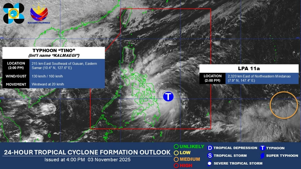
A new low-pressure area (LPA 11a) has formed outside the Philippine Area of Responsibility (PAR) and has a “medium potential” of developing into a tropical depression within the next 24 hours, the Philippine Atmospheric, Geophysical and Astronomical Services Administration (PAGASA) said on Monday afternoon, Nov. 3.
As of 2 p.m., the LPA was located 2,320 kilometers east of northeastern Mindanao.
PAGASA’s two-week tropical cyclone threat forecast shows that a Tropical Cyclone-like Vortex (TCLV1) may form in the eastern part of the Tropical Cyclone Information Domain (TCID) during Week 1 (Nov. 3–9).
It is highly likely to become a tropical cyclone and enter the PAR in Week 1 of the forecast period, it added.
During Week 2 (Nov. 10-16), PAGASA said TCLV1 is expected to head toward Northern-Central Luzon, with still a high likelihood of becoming a tropical cyclone.
However, the potential cyclone is still far from the country, and its track could still change.
PAGASA’s next tropical cyclone name is “Uswan.”
Meanwhile, Typhoon Tino (international name: Kalmaegi) remains inside PAR and is expected to further intensify before making landfall over parts of Eastern Visayas, then traverse the Visayas toward Southern Luzon between Monday, Nov. 3, and Tuesday, Nov. 4.