


Manila Bulletin
 Philippines
National
'Tino' may rapidly intensify within 48 hours; could make landfall as a typhoon
Philippines
National
'Tino' may rapidly intensify within 48 hours; could make landfall as a typhoon
Philippines
National
'Tino' may rapidly intensify within 48 hours; could make landfall as a typhoon
'Tino' may rapidly intensify within 48 hours; could make landfall as a typhoon
PAGASA not ruling out possible intensification into super typhoon
Published Nov 2, 2025 12:38 pm
|
Updated Nov 2, 2025 02:03 pm


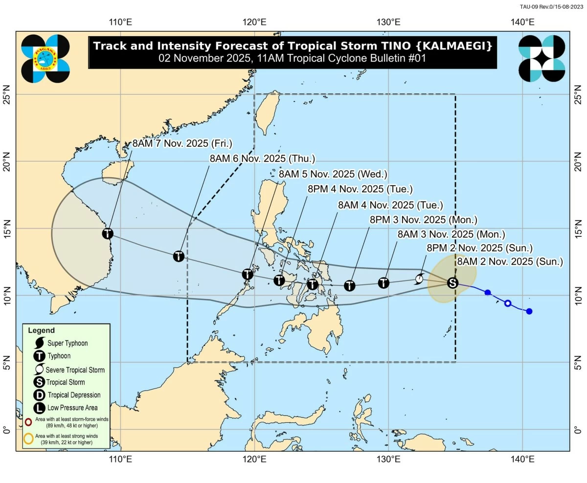
Tropical Storm Tino (Kalmaegi) track and intensity forecast (PAGASA)
The Philippine Atmospheric, Geophysical and Astronomical Services Administration (PAGASA) on Sunday, Nov. 2, said Tropical Storm Tino (international name: Kalmaegi) may undergo rapid intensification within 48 hours and could make landfall as a typhoon over Eastern Samar or Dinagat Islands late Monday, Nov. 3, or early Tuesday, Nov. 4.
In its first tropical cyclone bulletin issued at 11 a.m., PAGASA said Tino had maximum sustained winds of 85 kilometers per hour (kph) near the center and gustiness of up to 105 kph.
PAGASA said Tino may continuously intensify and reach typhoon category within the next 24 hours.
It is expected to make its initial landfall at or near peak intensity, currently forecast at around 150 to 155 kph maximum winds.
“Rapid intensification within the next 48 hours is likely,” PAGASA said.
It added that the possibility of Tino reaching super typhoon category “is not ruled out based on alternate scenarios and climatological data.”
As of 10 a.m., the center of Tino was located 955 kilometers east of Eastern Visayas. It was moving westward at 30 kph.
Track and intensity forecast
Based on the latest track forecast, Tino will move generally westward over the next three days and make its initial landfall over Eastern Samar or Dinagat Islands late Monday evening or early Tuesday morning.
After crossing the Visayas and northern Palawan, the tropical cyclone is expected to emerge over the West Philippine Sea by Wednesday morning or afternoon, Nov. 5.
While a slight weakening may occur as it crosses land, PAGASA said Tino is likely to remain a typhoon throughout its passage over the country.
In anticipation of strong winds, PAGASA raised Tropical Cyclone Wind Signal No. 1 over Eastern Samar, Dinagat Islands, and Siargao and Bucas Grande Islands.
Minimal to minor impacts from strong winds are possible within these areas.
The highest wind signal that may be hoisted during Tino’s passage is Signal No. 4, considering its potential to intensify into a typhoon.
Sea conditions
PAGASA also warned of possible coastal flooding due to storm surge over low-lying and coastal areas in the Visayas and parts of Southern Luzon and Mindanao.
The risk is higher in areas near or slightly north of Tino’s projected path.
PAGASA added that a gale warning may be raised over the eastern seaboards of Eastern Visayas and Caraga tonight or by Monday morning due to expected very rough sea conditions.
Seas may become rough to very rough, reaching up to 4.0 meters over the seaboards of Batanes and Babuyan Islands and the eastern seaboards of mainland Cagayan and Isabela; up to 3.5 meters over the seaboards of Eastern Samar, Dinagat Islands, and Siargao and Bucas Grande Islands; and up to 3.0 meters over the seaboards of Northern and Central Luzon and Bicol Region.
Mariners of small vessels, including motorbancas, are advised not to venture out to sea under these conditions, especially if inexperienced or operating ill-equipped boats.
Heavy rainfall outlook
PAGASA said the onset of heavy rains due to Tino is expected by Monday.
From Monday noon to Tuesday noon, rainfall of 100 to 200 millimeters (heavy to intense) is expected over Eastern Samar, Southern Leyte, Leyte, Cebu, Bohol, Dinagat Islands, Surigao del Norte, and Agusan del Norte.
Rainfall of 50 to 100 millimeters (moderate to heavy) could be experienced in Catanduanes, Albay, Masbate, Sorsogon, Northern Samar, Samar, Biliran, Iloilo, Capiz, Negros Occidental, Aklan, Romblon, Guimaras, Siquijor, Misamis Oriental, and Surigao del Sur.
From Tuesday noon to Wednesday noon, rainfall of 100 to 200 millimeters is forecast over Cebu, Bohol, Negros Oriental, Negros Occidental, Guimaras, Iloilo, Capiz, Aklan, Antique, Oriental Mindoro, and Palawan, while 50 to 100 millimeters is possible over Albay, Masbate, Sorsogon, Marinduque, Romblon, Occidental Mindoro, Biliran, Leyte, Southern Leyte, Siquijor, Agusan del Norte, Bukidnon, Camiguin, Lanao del Norte, Misamis Occidental, Misamis Oriental, Lanao del Sur, Maguindanao del Norte, Maguindanao del Sur, Sultan Kudarat, and Zamboanga del Norte.
Meanwhile, the shear line, or the boundary between the northeast monsoon (amihan) and easterlies, will continue to bring rains over parts of Luzon.
Rainfall of 50 to 100 millimeters is expected over Isabela, Aurora, Quezon, Camarines Norte, Camarines Sur, Oriental Mindoro, and Marinduque from Monday noon to Tuesday noon, while moderate to heavy rains may persist in Cagayan, Isabela, Aurora, Quezon, and Camarines Norte from Tuesday noon to Wednesday noon.
PAGASA advised residents in low-lying and mountainous areas to remain vigilant against possible flooding and rain-induced landslides.