


Manila Bulletin
 Philippines
National
PAGASA monitors new LPA; may develop into tropical cyclone in coming days
Philippines
National
PAGASA monitors new LPA; may develop into tropical cyclone in coming days
Philippines
National
PAGASA monitors new LPA; may develop into tropical cyclone in coming days
PAGASA monitors new LPA; may develop into tropical cyclone in coming days
Published Oct 30, 2025 10:47 am


PAGASA
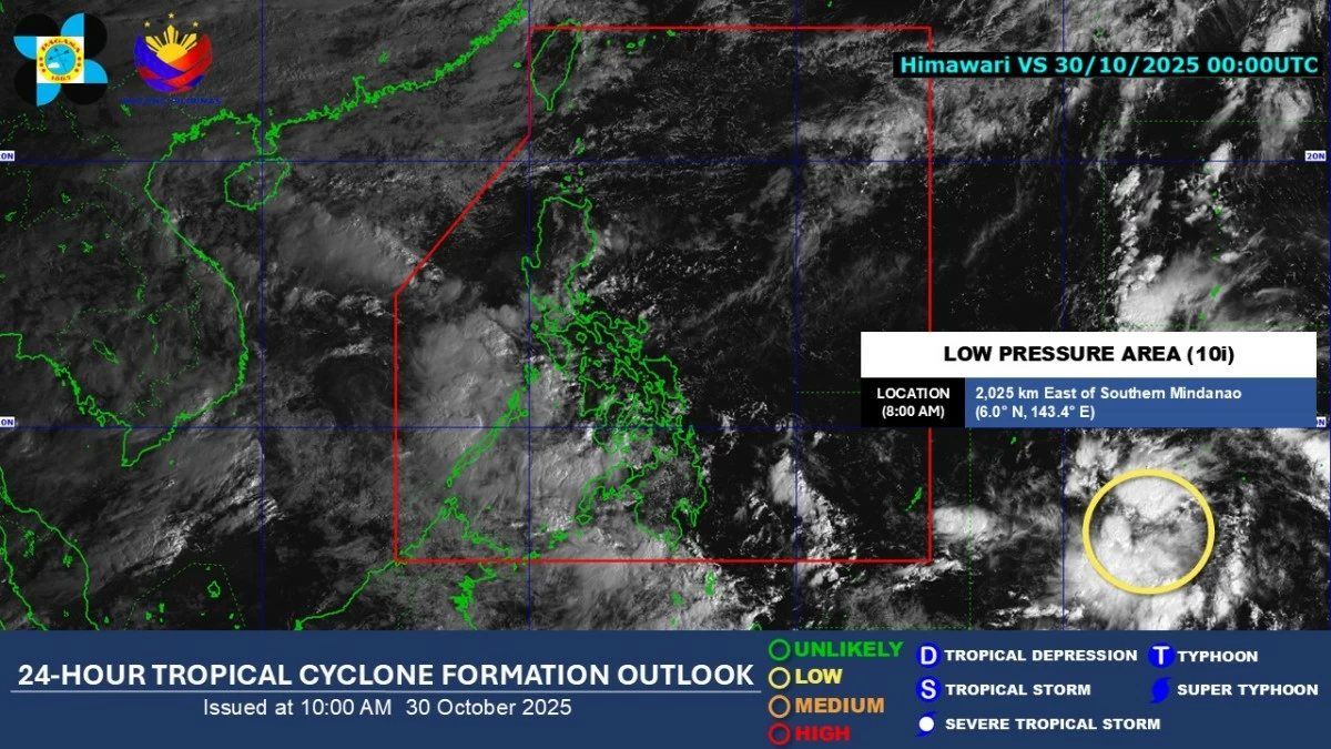
The Philippine Atmospheric, Geophysical and Astronomical Services Administration (PAGASA) on Thursday, Oct. 30, said it is monitoring a new low-pressure area (LPA 10i) located 2,025 kilometers east of southern Mindanao that may develop into a tropical cyclone in the next few days.
PAGASA weather specialist Chenel Dominguez said the LPA has a low chance of developing into a tropical depression within the next 24 hours, but the likelihood will gradually increase in the following days.
According to Dominguez, the weather disturbance may enter the Philippine area of responsibility (PAR) by Sunday or Monday, Nov. 2 or 3.
She said PAGASA is considering two possible scenarios for the system’s movement.
In the first scenario, the LPA will move generally northwestward, remain almost stationary or move slowly over the Philippine Sea, and may make landfall over Northern Luzon by Nov. 9.
In the second scenario, it may move west-northwestward and could make landfall over Eastern Visayas by Nov. 4.
Dominguez said the LPA remains far from the country, and its forecast track may still change in the coming days.
She added that it currently has no direct effect on any part of the Philippines and advised the public to continue monitoring PAGASA’s updates.
Should the LPA develop into a tropical cyclone within the PAR, PAGASA will be giving it the local name “Tino.”
Meanwhile, the intertropical convergence zone (ITCZ)—a region where winds from the northern and southern hemispheres meet, often resulting in the development of clouds and rain showers—will continue to bring cloudy skies with scattered rain showers and thunderstorms over Visayas, Mindanao, Bicol Region, Oriental Mindoro, Occidental Mindoro, Marinduque, Romblon, and Palawan within the next 24 hours.
Cloudy skies with rains may also prevail over Batanes, Cagayan, Apayao, and Ilocos Norte due to the northeast monsoon (amihan), while the shear line—the boundary where cold and warm air masses collide, causing rain showers or thunderstorms—may bring cloudy skies with scattered rains and isolated thunderstorms over Metro Manila, Cavite, Laguna, Batangas, Rizal, Quezon, Aurora, and Isabela.
The rest of the country will experience partly cloudy to cloudy skies with isolated rain showers caused by localized thunderstorms.
PAGASA warned the public to remain alert for possible flash floods and landslides, particularly during moderate to heavy rainfall or severe thunderstorms.