


Manila Bulletin
 Philippines
National
PAGASA: 'Salome' expected to pass close to or over Babuyan Islands, Ilocos Norte in the next few hours
Philippines
National
PAGASA: 'Salome' expected to pass close to or over Babuyan Islands, Ilocos Norte in the next few hours
Philippines
National
PAGASA: 'Salome' expected to pass close to or over Babuyan Islands, Ilocos Norte in the next few hours
PAGASA: 'Salome' expected to pass close to or over Babuyan Islands, Ilocos Norte in the next few hours
Published Oct 23, 2025 08:35 am


PAGASA
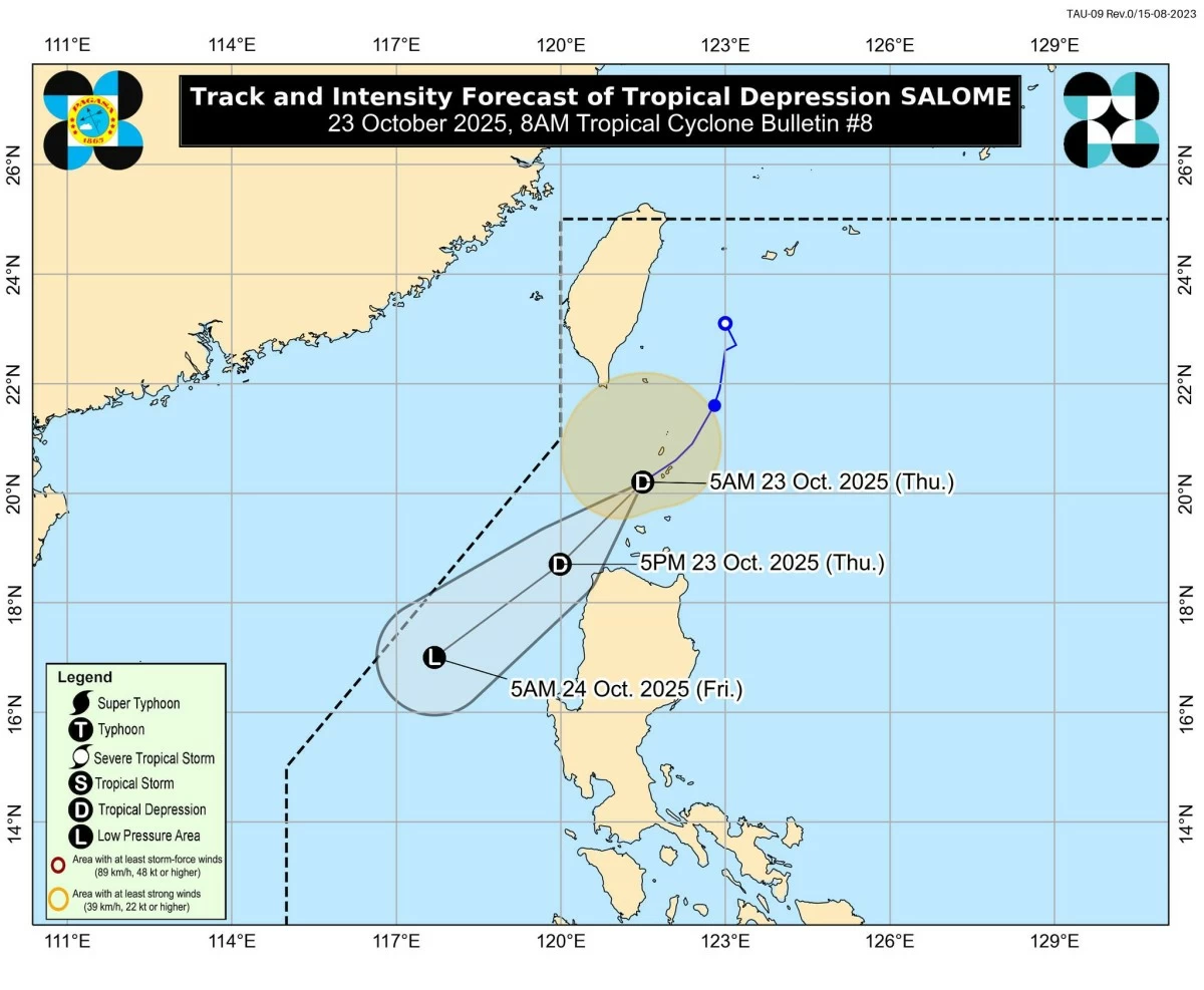
The Philippine Atmospheric, Geophysical and Astronomical Services Administration (PAGASA) said on Thursday, Oct. 23, that Tropical Depression Salome is expected to pass near or over the Babuyan Islands this morning and over Ilocos Norte by noon or afternoon.
In its 8 a.m. bulletin, PAGASA said the center of Salome’s circulation was estimated at 85 kilometers southwest of Basco, Batanes.
It was moving southwestward at 20 kilometers per hour (kph), with maximum sustained winds of 55 kph near the center and gustiness of up to 75 kph.
PAGASA said Salome will continue to move generally southwestward throughout the forecast period due to the influence of a high-pressure area over mainland China.
The weather bureau said the tropical depression passed over Batanes as a tropical storm earlier on Thursday.
PAGASA initially raised Tropical Cyclone Wind Signal No. 2 over the province but later downgraded it to Signal No. 1 after the system weakened into a tropical depression.
In its latest bulletin, PAGASA raised Signal No. 1 over Batanes, the northern and western portions of the Babuyan Islands (Calayan Island, Dalupiri Island, Babuyan Island), and the northwestern portion of Ilocos Norte, including the towns of Bangui, Pagudpud, Burgos, Pasuquin, Bacarra, and Laoag City.
Residents in these areas are advised to remain alert for possible gusty conditions, especially in elevated or coastal areas.