ADVERTISEMENT

PAGASA: 'Salome' may pass near or make landfall over Batanes in the coming hours

Published Oct 22, 2025 05:39 pm
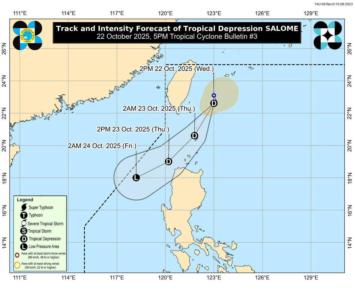
Forecast track and intensity of Tropical Depression Salome (PAGASA)
The Philippine Atmospheric, Geophysical and Astronomical Services Administration (PAGASA) on Wednesday, Oct. 22 said Tropical Depression Salome may pass close to or make landfall over Batanes this evening or early morning on Thursday, Oct. 23 as it moves southwestward toward Northern Luzon.
As of 4 p.m., the center of the tropical depression was located 215 kilometers north-northeast of Itbayat, Batanes, with maximum sustained winds of 55 kilometers per hour (kph) near the center and gustiness of up to 70 kph.
It was moving west-southwestward at 10 kph.
PAGASA said Salome is expected to move generally southwestward throughout the forecast period due to the high-pressure area over mainland China.
On its forecast track, Salome may also pass close to the Babuyan Islands on Thursday morning and over Ilocos Norte by Thursday afternoon.
The weather disturbance is likely to remain a tropical depression before weakening into a remnant low on Friday, though PAGASA said a slight intensification into a tropical storm is not ruled out.
Tropical Cyclone Wind Signal No. 1 remains hoisted over Batanes, western portion of Babuyan Islands (Calayan and Dalupiri Islands), and northwestern portion of Ilocos Norte (Bangui, Pagudpud, Burgos, Pasuquin, Bacarra, and Laoag City).
PAGASA added that should Salome intensify further, Signal No. 2 may be hoisted.
Over the next 24 hours, Batanes, Babuyan Islands, and Ilocos Norte will experience cloudy skies with rains and gusty winds due to Salome, while cloudy skies with scattered rains and thunderstorms are expected over Apayao and mainland Cagayan.
Meanwhile, the Intertropical Convergence Zone (ITCZ) will bring cloudy skies with scattered rains and thunderstorms over Mindanao and Palawan.
ITCZ is an area where winds from the northern and southern hemispheres converge, often bringing rain clouds and thunderstorms.
Moreover, PAGASA said the easterlies, or warm winds from the Pacific Ocean, will continue to bring partly cloudy to cloudy skies with isolated rain showers or thunderstorms over Bicol Region, Eastern Visayas, Isabela, Aurora, and Quezon.
Metro Manila and the rest of the country will have partly cloudy to cloudy skies with isolated rain showers caused by localized thunderstorms.
PAGASA advised the public to stay alert for possible flash floods and landslides, especially in areas experiencing moderate to heavy rains or severe thunderstorms.

Related Tags

PAGASA TROPICAL DEPRESSION SALOME LANDFALL SIGNAL NO. 1
ADVERTISEMENT
.most-popular .layout-ratio{ padding-bottom: 79.13%; } @media (min-width: 768px) and (max-width: 1024px) { .widget-title { font-size: 15px !important; } }

{{ articles_filter_1561_widget.title }}

.most-popular .layout-ratio{ padding-bottom: 79.13%; } @media (min-width: 768px) and (max-width: 1024px) { .widget-title { font-size: 15px !important; } }

{{ articles_filter_1562_widget.title }}

.most-popular .layout-ratio{ padding-bottom: 79.13%; } @media (min-width: 768px) and (max-width: 1024px) { .widget-title { font-size: 15px !important; } }

{{ articles_filter_1563_widget.title }}

{{ articles_filter_1564_widget.title }}

.mb-article-details { position: relative; } .mb-article-details .article-body-preview, .mb-article-details .article-body-summary{ font-size: 17px; line-height: 30px; font-family: "Libre Caslon Text", serif; color: #000; } .mb-article-details .article-body-preview iframe , .mb-article-details .article-body-summary iframe{ width: 100%; margin: auto; } .read-more-background { background: linear-gradient(180deg, color(display-p3 1.000 1.000 1.000 / 0) 13.75%, color(display-p3 1.000 1.000 1.000 / 0.8) 30.79%, color(display-p3 1.000 1.000 1.000) 72.5%); position: absolute; height: 200px; width: 100%; bottom: 0; display: flex; justify-content: center; align-items: center; padding: 0; } .read-more-background a{ color: #000; } .read-more-btn { padding: 17px 45px; font-family: Inter; font-weight: 700; font-size: 18px; line-height: 16px; text-align: center; vertical-align: middle; border: 1px solid black; background-color: white; } .hidden { display: none; }
function initializeAllSwipers() { // Get all hidden inputs with cms_article_id document.querySelectorAll('[id^="cms_article_id_"]').forEach(function (input) { const cmsArticleId = input.value; const articleSelector = '#article-' + cmsArticleId + ' .body_images'; const swiperElement = document.querySelector(articleSelector); if (swiperElement && !swiperElement.classList.contains('swiper-initialized')) { new Swiper(articleSelector, { loop: true, pagination: false, navigation: { nextEl: '#article-' + cmsArticleId + ' .swiper-button-next', prevEl: '#article-' + cmsArticleId + ' .swiper-button-prev', }, }); } }); } setTimeout(initializeAllSwipers, 3000); const intersectionObserver = new IntersectionObserver( (entries) => { entries.forEach((entry) => { if (entry.isIntersecting) { const newUrl = entry.target.getAttribute("data-url"); if (newUrl) { history.pushState(null, null, newUrl); let article = entry.target; // Extract metadata const author = article.querySelector('.author-section').textContent.replace('By', '').trim(); const section = article.querySelector('.section-info ').textContent.replace(' ', ' '); const title = article.querySelector('.article-title h1').textContent; // Parse URL for Chartbeat path format const parsedUrl = new URL(newUrl, window.location.origin); const cleanUrl = parsedUrl.host + parsedUrl.pathname; // Update Chartbeat configuration if (typeof window._sf_async_config !== 'undefined') { window._sf_async_config.path = cleanUrl; window._sf_async_config.sections = section; window._sf_async_config.authors = author; } // Track virtual page view with Chartbeat if (typeof pSUPERFLY !== 'undefined' && typeof pSUPERFLY.virtualPage === 'function') { try { pSUPERFLY.virtualPage({ path: cleanUrl, title: title, sections: section, authors: author }); } catch (error) { console.error('ping error', error); } } // Optional: Update document title if (title && title !== document.title) { document.title = title; } } } }); }, { threshold: 0.1 } ); function showArticleBody(button) { const article = button.closest("article"); const summary = article.querySelector(".article-body-summary"); const body = article.querySelector(".article-body-preview"); const readMoreSection = article.querySelector(".read-more-background"); // Hide summary and read-more section summary.style.display = "none"; readMoreSection.style.display = "none"; // Show the full article body body.classList.remove("hidden"); } document.addEventListener("DOMContentLoaded", () => { let loadCount = 0; // Track how many times articles are loaded const offset = [1, 2, 3, 4, 5, 6, 7, 8, 9, 10]; // Offset values const currentUrl = window.location.pathname.substring(1); let isLoading = false; // Prevent multiple calls if (!currentUrl) { console.log("Current URL is invalid."); return; } const sentinel = document.getElementById("load-more-sentinel"); if (!sentinel) { console.log("Sentinel element not found."); return; } function isSentinelVisible() { const rect = sentinel.getBoundingClientRect(); return ( rect.top < window.innerHeight && rect.bottom >= 0 ); } function onScroll() { if (isLoading) return; if (isSentinelVisible()) { if (loadCount >= offset.length) { console.log("Maximum load attempts reached."); window.removeEventListener("scroll", onScroll); return; } isLoading = true; const currentOffset = offset[loadCount]; window.loadMoreItems().then(() => { let article = document.querySelector('#widget_1690 > div:nth-last-of-type(2) article'); intersectionObserver.observe(article) loadCount++; }).catch(error => { console.error("Error loading more items:", error); }).finally(() => { isLoading = false; }); } } window.addEventListener("scroll", onScroll); });

Sign up by email to receive news.