


Manila Bulletin
 Philippines
National
'Ramil' likely to make landfall over Catanduanes, Quezon–Aurora this weekend
Philippines
National
'Ramil' likely to make landfall over Catanduanes, Quezon–Aurora this weekend
Philippines
National
'Ramil' likely to make landfall over Catanduanes, Quezon–Aurora this weekend
'Ramil' likely to make landfall over Catanduanes, Quezon–Aurora this weekend
Heavy rains seen over Luzon, E. Visayas
Published Oct 17, 2025 01:10 pm


At A Glance
- Signal No. 1 has been hoisted over 11 areas in Luzon and Visayas
- PAGASA said "Ramil" may make intensify into a tropical storm this evening
- The highest wind signal likely to be raised during Ramil's passage is Signal No. 2, but it did not rule out the possibility of Signal No. 3 if the cyclone intensifies into a severe tropical storm before landfall
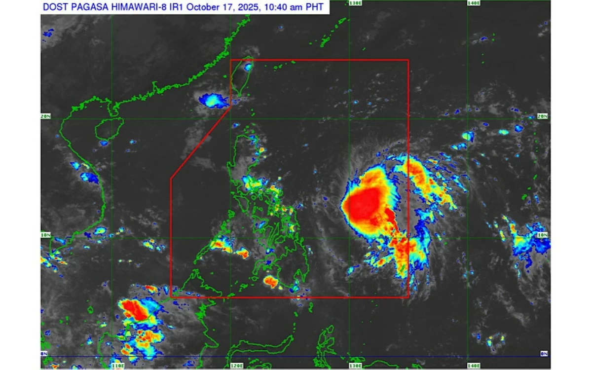
PAGASA
Tropical Depression Ramil is expected to bring widespread rains and strong winds over parts of Luzon and Eastern Visayas as it traverses the country this weekend, the Philippine Atmospheric, Geophysical and Astronomical Services Administration (PAGASA) said on Friday, Oct. 17.
As of 10 a.m., the center of Ramil was estimated 760 kilometers east of Virac, Catanduanes, packing maximum sustained winds of 55 kilometers per hour (kph) near the center and gustiness of up to 70 kph.
It was moving southwestward at 25 kph.
PAGASA weather specialist Benison Estareja said Ramil has slightly intensified and may strengthen into a tropical storm by Friday evening.
Landfall imminent
Based on its latest track, PAGASA said Ramil is projected to continue moving westward before turning west-northwestward.
It could make its first landfall over Catanduanes on Saturday afternoon, Oct. 18, and another landfall over northern Quezon or southern Aurora by Saturday evening or Sunday morning, Oct. 19, before crossing the southern portion of Luzon and the rest of Central Luzon throughout the day.
“Ramil may make two or three landfalls depending on the islands it passes over, particularly in Catanduanes and the eastern parts of Camarines Norte and Albay,” Estareja said in a press conference.
He added that PAGASA is still monitoring any possible shift in the storm’s track.
While the system is currently expected to track across northern Bicol, it could still shift northward and make its first landfall over Aurora–Isabela area, he said.
“However, a more southward movement means it may pass close to Northern Samar, then make landfall over Albay, southern Catanduanes, or Camarines Sur before traversing the rest of Camarines Sur and Quezon,” Estareja added.
He also said a close approach to Metro Manila and the northern portion of Calabarzon cannot be ruled out, as the cyclone may cross Central Luzon from late Saturday until Monday, Oct. 20, in the event of a more southward track.
Ramil may exit the Philippine Area of Responsibility by Monday.
Signal No. 1 in effect
Tropical Cyclone Wind Signal No. 1 has been raised over the eastern and southern portions of Quezon (Tagkawayan, Perez, Alabat, Quezon, Atimonan, Padre Burgos, Unisan, Gumaca, Plaridel, Agdangan, Pagbilao, Mauban, Calauag, Guinayangan, Lopez, Pitogo, Macalelon, General Luna, Catanauan, San Narciso, Buenavista, San Francisco, San Andres, and Mulanay), including the Polillo Islands, Camarines Norte, Camarines Sur, Catanduanes, Albay, Sorsogon, Burias Island, and Ticao Island.
Signal No. 1 is also hoisted over Northern Samar, the northern portion of Eastern Samar (San Policarpo, Arteche, Oras, Dolores, Maslog, Jipapad, Taft, and Can-Avid), and the northern portion of Samar (Matuguinao, San Jose de Buan, Calbayog City, Gandara, Santa Margarita, Pagsanghan, and San Jorge).
Estareja said the highest wind signal likely to be raised during Ramil’s passage is Signal No. 2, but he did not rule out the possibility of Signal No. 3 if the cyclone intensifies into a severe tropical storm before landfall.
Heavy rainfall forecast
From Friday until Saturday noon, moderate to heavy rains ranging from 50 to 100 millimeters are expected over Catanduanes, Albay, Sorsogon, Masbate, Northern Samar, Eastern Samar, and Samar.
Between Saturday noon and Sunday noon, 100 to 200 millimeters of rainfall (heavy to intense) may affect Isabela, Aurora, Quezon, Camarines Norte, Camarines Sur, and Catanduanes,
Moderate to heavy rains are likely over Kalinga, Mountain Province, Ifugao, Benguet, Cagayan, Quirino, Nueva Vizcaya, Nueva Ecija, Bulacan, Metro Manila, Rizal, Laguna, Marinduque, Albay, Sorsogon, and Northern Samar.
From Sunday noon to Monday noon, moderate to heavy rainfall is forecast over Ilocos Norte, Ilocos Sur, La Union, Pangasinan, Apayao, Abra, Kalinga, Mountain Province, Ifugao, Benguet, Cagayan, Isabela, Quirino, Nueva Vizcaya, Aurora, Nueva Ecija, Tarlac, and Zambales.
Estareja also said Metro Manila may experience cloudy skies and frequent rains starting Sunday as the weather disturbance crosses Luzon.
PAGASA advised residents in low-lying and mountainous areas to remain vigilant against possible flooding and rain-induced landslides, and to continue monitoring official updates.