


Manila Bulletin
 Philippines
National
LPA east of Mindanao may develop into Tropical Depression Ramil within 24 to 48 hours — PAGASA
Philippines
National
LPA east of Mindanao may develop into Tropical Depression Ramil within 24 to 48 hours — PAGASA
Philippines
National
LPA east of Mindanao may develop into Tropical Depression Ramil within 24 to 48 hours — PAGASA
LPA east of Mindanao may develop into Tropical Depression Ramil within 24 to 48 hours — PAGASA
Published Oct 15, 2025 08:04 am


PAGASA
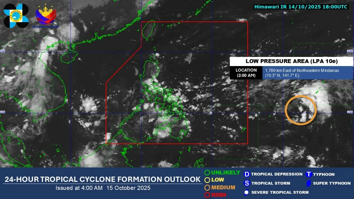
A low-pressure area (LPA) located outside the Philippine Area of Responsibility (PAR) continues to show signs of strengthening and may develop into a tropical depression within the next 24 to 48 hours, the Philippine Atmospheric, Geophysical and Astronomical Services Administration (PAGASA) said on Wednesday, Oct. 15.
PAGASA weather specialist Chenel Dominguez said the LPA was estimated at 1,765 kilometers east of northeastern Mindanao as of 3 a.m. on Wednesday.
Once it intensifies into a tropical cyclone and enters the PAR, it will be given the local name “Ramil.”
Dominguez said the potential cyclone may move closer to Northern Luzon and could bring rains over a large portion of Luzon by the weekend.
However, she noted that the LPA remains far from the country and its forecast track may still change.
Dominguez said PAGASA is closely monitoring the weather disturbance and advised the public to await further updates.
Meanwhile, the easterlies, or warm winds from the Pacific Ocean, and the initial surge of cool air from the northeast, called the northeasterly windflow, will continue to prevail over the country in the next 24 hours.
Cloudy skies with scattered rain showers and thunderstorms are expected over Metro Manila, Calabarzon, Bicol Region, Eastern Visayas, Isabela, Aurora, Nueva Ecija, Bulacan, Marinduque, Oriental Mindoro, Romblon, Capiz, Aklan, Cebu, and Bohol due to the easterlies.
Batanes, Cagayan, Apayao, and Ilocos Norte may also experience partly cloudy to cloudy skies with isolated light rains due to the northeasterly windflow.
Meanwhile, the rest of Luzon and Visayas will have partly cloudy to cloudy skies with isolated rain showers or thunderstorms from the easterlies, while localized thunderstorms may affect parts of Mindanao.
PAGASA advised the public to remain alert for possible flash floods and landslides, particularly during moderate to heavy rainfall or severe thunderstorms.