


Manila Bulletin
 Philippines
Mindanao
Phivolcs: Davao Oriental quake one of strongest to rock Mindanao in past decade
Philippines
Mindanao
Phivolcs: Davao Oriental quake one of strongest to rock Mindanao in past decade
Philippines
Mindanao
Phivolcs: Davao Oriental quake one of strongest to rock Mindanao in past decade
Phivolcs: Davao Oriental quake one of strongest to rock Mindanao in past decade
Published Oct 13, 2025 01:43 pm


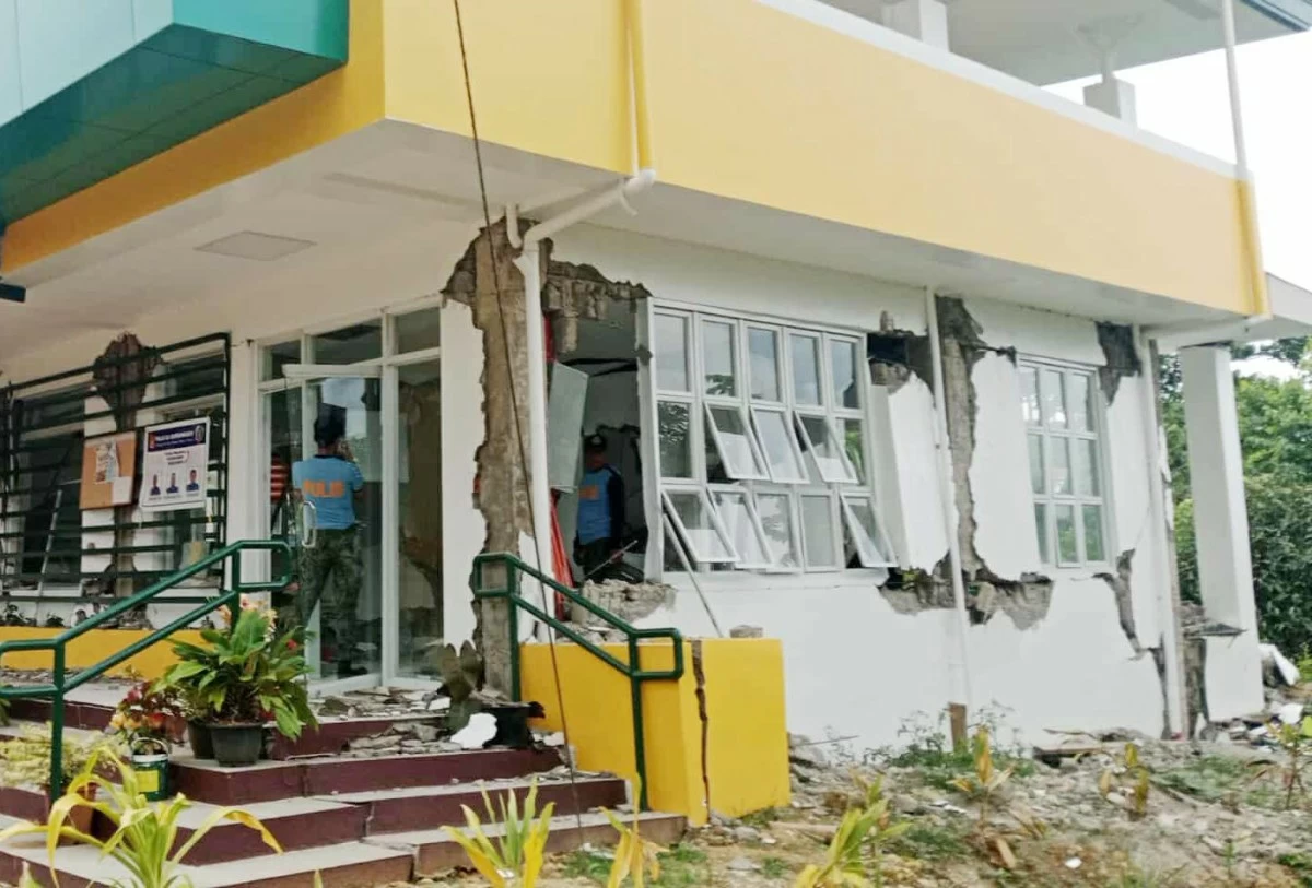
A STRUCTURE damaged by the Oct. 11 earthquake in Manay, Davao Oriental. (Manay police)
DAVAO CITY – The magnitude-7.4 earthquake that hit the coastal town of Manay in Davao Oriental province on Oct. 11 was one of the strongest to hit Mindanao in the last decade.
But it was not the first destructive tremor to ravage the municipality and Mindanao.
The Philippine Institute of Volcanology and Seismology said that eight earthquakes over magnitude six have jolted Mindanao since 2017.
Phivolcs classified a magnitude-six earthquake as very strong that could cause damage to very old or poorly built houses and man-made structures.
It could also cause rockfalls and rolling boulders may occur in hilly to mountainous areas and escarpments, Phivolcs said in its earthquake intensity scale.
Eastern Mindanao region was rattled by strong earthquakes in 2023.
On March 6 and 7, a series of light to moderate earthquakes shook the province of Davao de Oro and neighboring areas.
The highest magnitude recorded by the Philippine Seismic Network was magnitude-5.9 which was felt by the Phivolcs Earthquake Intensity Scale (PEIS) at V (strong) in the municipalities of New Bataan, Maragusan, Nabunturan, Maco, and Pantukan, all in Davao de Oro.
On Nov. 17, a magnitude-6.8 tremor shook the municipality of Sarangani in Davao Occidental and was felt in many parts of Mindanao.
The earthquake's epicenter was 28 kilometers southwest of Sarangani with a depth of 63 kilometers.
Eleven people were killed and 37 were injured.
The National Disaster Risk Reduction and Management Council (NDRRMC) reported that 602 houses were totally destroyed and 5,983 were partially damaged.
On Dec. 2, a magnitude-7.4 earthquake jolted Hinatuan, Surigao del Sur and was also felt in many parts of Mindanao. The earthquake’s epicenter was 29 kilometers northeast of Hinatuan and had an estimated depth of 26 kilometers.
The NDRRMC reported three deaths and 79 injuries.Three-hundred ninety houses were totally destroyed and 8,315 were partially damaged.
Two days later, a magnitude 6.8-tremor jolted Surigao del Sur. Its epicenter was 48 kilometers northeast off the coast of Lingig town. Two houses were totally damaged while 191 were partially damaged.
Like the earthquake last Friday, the previous Surigao del Sur earthquake was associated with subduction on the Philippine Trench.
About nine hours after the magnitude-7.4 struck, a magnitude-6.8 undersea tremor also jolted the region.
While considered rare, Phivolcs said called it a doublet earthquake, which usually occurs in the same fault. The magnitude-7.4 earthquake was felt in almost the entire Mindanao except for Zamboanga region. Eight persons were killed as of Oct. 13.
The NDRRMC said 125,283 families or 491,258 people were affected.
As of 11 a.m. Oct. 13, Phivolcs logged 1,203 aftershocks but only 14 of these were felt.
In October and December 2019, Phivolcs said a sequence of five shallow and strong earthquakes jolted the provinces of Cotabato and Davao del Sur.
The first strong earthquake took place on Oct. 16 with a magnitude of 6.3, Oct. 29 with magnitudes 6.6 and 6.1, and Oct. 31 with a magnitude of 6.5. On Dec. 15, a magnitude-6.9 earthquake shook almost the same area.
History of earthquakes
Phivolcs said that powerful earthquakes are not new to the Eastern Mindanao region, more particularly the adjacent provinces of Davao Oriental and Surigao del Sur, due to the province’s proximity to the Philippine Trench and the Philippine Fault’s East Compostela Valley, West Compostela Valley, Central Compostela Valley, Nabunturan, Caraga River, and Mati Segments.
It added that Davao Oriental and its neighboring provinces are situated in one of the seismically active regions in the country.
Phivolcs said that six significant earthquakes with magnitudes ranging from 7.1 to 8.3 have hit Davao Oriental and nearby provinces between 1885 and 2023 based on historical records.
It added Manay have been hit by destructive earthquakes with magnitudes 7.1 and 7.5 on May 17, 1992. These twin earthquakes took place two 26 minutes apart, according to Phivolcs.
“The hypocenter for these earthquakes was located offshore of the municipalities of Caraga and Manay, province of Davao Oriental with shallow depths of less than 33 kilometers,” Phivolcs said.
The agency classified it as a destructive earthquake as it damaged residential houses in the coastal municipalities of Manay, Cateel, Baganga, Boston, Caraga, and Tarragona.
“Tsunami wave heights for these events were three to six meters along the coast of Caraga and Manay,” said Phivolcs as it noted that the source of the tremors was the subduction on the Philippine Trench.
No casualties were reported in the twin tremors but Phivolcs noted that these affected the livelihood and houses of communities living on the coastlines.
The most destructive earthquake to hit Mindanao was the magnitude-8.1 Moro Gulf earthquake and tsunami. The tremor occurred at 12:11 a.m. on Aug. 17, 1976, with an epicenter located in Moro Gulf, approximately 40 kilometers in the sea of Sultan Kudarat province.
It was widely felt in Sultan Kudarat, Zamboanga, Cotabato, Maguindanao, and the rest of southern Mindanao with a maximum intensity of Rossi-Forel (RF) VII, equivalent to Phivolcs Earthquake Intensity Scale (PEIS) VIII (very destructive).
The offshore earthquake triggered a devastating tsunami that killed more than 8,000 people and injured at least 10,000 persons.
About 90,000 families were displaced. Damage to property was placed at P410 million.