


Typhoon Paolo makes landfall; Signal No. 4 raised
Published Oct 3, 2025 11:37 am
|
Updated Oct 3, 2025 02:40 pm


PAGASA
Strong winds and heavy rains battered Dinapigue, Isabela on Friday, Oct. 3 as Typhoon Paolo (international name: Matmo) made landfall at 9 a.m., said the Philippine Atmospheric, Geophysical and Astronomical Services Administration (PAGASA).
It had maximum sustained winds of 130 kilometers per hour (kph) near the center and gustiness of up to 215 kph at landfall.
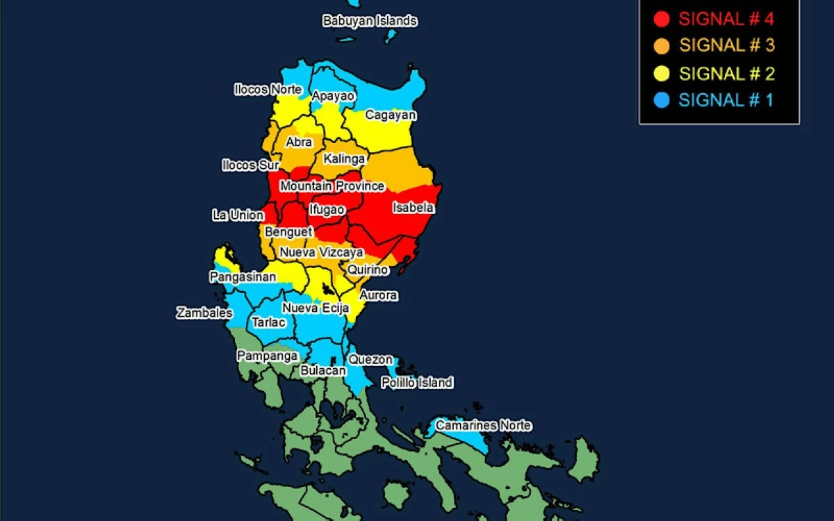
PAGASA immediately raised Tropical Cyclone Wind Signal No. 4 in affected areas of Luzon.
As of the 11 a.m. bulletin, the following areas are under tropical cyclone wind signals:
Signal No. 4
* Extreme northern portion of Aurora (Dilasag, Casiguran)
* Southern portion of Isabela (Dinapigue, San Mariano, Palanan, Roxas, Burgos, Gamu, Naguilian, Benito Soliven, San Manuel, Cabatuan, Aurora, Luna, Reina Mercedes, Cauayan City, San Mateo, Alicia, Ramon, Santiago City, Cordon, San Isidro, Echague, Angadanan, San Guillermo, Jones, San Agustin)
* Northern portion of Quirino (Diffun, Aglipay, Saguday, Cabarroguis, Maddela)
* Northern portion of Nueva Vizcaya (Solano, Villaverde, Bagabag, Diadi, Quezon, Ambaguio, Bayombong)
* Mountain Province
* Ifugao
* Southern portion of Abra (Tubo)
* Northern portion of Benguet (Bakun, Mankayan, Buguias, Kibungan, Kapangan, Atok, Kabayan)
* Southern portion of Ilocos Sur (Cervantes, Quirino, Gregorio del Pilar, Sigay, San Emilio, Salcedo, Burgos, Lidlidda, Banayoyo, San Esteban, Santiago, Candon City, Santa Lucia, Santa Cruz, Suyo, Alilem, Tagudin, Sugpon)
* Northern portion of La Union (Luna, Bangar, Balaoan, Sudipen, Santol, San Gabriel, Bacnotan, San Juan)
Signal No. 3
* Northern portion of Aurora (Dinalungan, Dipaculao)
* Rest of Isabela
* Rest of Quirino
* Central portion of Nueva Vizcaya (Kasibu, Bambang, Kayapa, Aritao, Dupax del Norte, Dupax del Sur, Santa Fe)
* Kalinga
* Central portion of Abra (Boliney, Daguioman, Sallapadan, Bucloc, Licuan-Baay, Malibcong, Lacub, La Paz, San Juan, Lagangilang, Danglas, Lagayan, Tayum, Bangued, Langiden, Pidigan, San Quintin, Pilar, Luba, Manabo, Villaviciosa, San Isidro, Peñarrubia, Bucay, Dolores)
* Rest of Benguet
* Rest of Ilocos Sur
* Rest of La Union
Signal No. 2
* Southern portion of Cagayan (Peñablanca, Tuguegarao City, Solana, Iguig, Tuao, Piat, Rizal, Santo Niño, Alcala, Amulung, Enrile, Baggao)
* Rest of Nueva Vizcaya
* Southern portion of Apayao (Conner, Kabugao)
* Rest of Abra
* Southern portion of Ilocos Norte (Nueva Era, Badoc, Pinili, Batac City, Paoay, Currimao, Banna, Laoag City, San Nicolas, Sarrat, Dingras, Solsona, Marcos, Bacarra, Piddig)
* Northern portion Pangasinan (San Fabian, Sison, Pozorrubio, Umingan, San Jacinto, Laoac, Binalonan, San Nicolas, Natividad, Tayug, San Manuel, Asingan, Santa Maria, San Quintin, Dagupan City, Mangaldan, Manaoag, Bolinao, Anda, Bani, Alaminos City, Sual, Labrador, Lingayen, Binmaley, Calasiao, Mapandan, Santa Barbara, Urdaneta City)
* Central portion of Aurora (Baler, Maria Aurora, San Luis)
* Northern portion of Nueva Ecija (Carranglan, Bongabon, San Jose City, Pantabangan, Rizal, Lupao)
Signal No. 1
* Rest of mainland Cagayan (including Babuyan Islands)
* Rest of Aurora
* Northern Quezon (General Nakar, Infanta, including Polillo Islands)
* Camarines Norte
* Rest of Apayao
* Rest of Ilocos Norte
* Rest of Pangasinan
* Rest of Nueva Ecija
* Northern portion of Bulacan (Doña Remedios Trinidad, San Miguel, San Ildefonso, Norzagaray, San Rafael, Angat)
* Tarlac
* Northeastern portion of Pampanga (Magalang, Arayat, Candaba, Mabalacat City)
* Northern portion of Zambales (Palauig, Masinloc, Candelaria, Santa Cruz)
Rainfall outlook
Heavy rainfall is expected to continue from Friday, Oct. 3 until Saturday noon, Oct. 4.
Areas forecast to receive intense to torrential rainfall (more than 200 millimeters) include Isabela, Quirino, Ifugao, Mountain Province, Aurora, Nueva Vizcaya, and Benguet.
Heavy to intense rainfall (100 to 200 millimeters) is expected over Cagayan, Apayao, Abra, Kalinga, Nueva Ecija, Ilocos Sur, La Union, and Pangasinan.
Meanwhile, moderate to heavy rainfall (50 to 100 millimeters) is expected to persist in Ilocos Norte, Zambales, Tarlac, Bataan, Pampanga, Bulacan, Cavite, and Batangas.
Storm surge, gale warnings
PAGASA also warned of moderate to high risk of life-threatening storm surge with peak heights of one to three meters within 24 hours over low-lying coastal areas of Ilocos Norte, Ilocos Sur, La Union, Pangasinan, Zambales, Cagayan, Isabela, Aurora, and Quezon.
Meanwhile, areas at high risk of storm surge exceeding three meters within 36 hours include coastal localities of Zambales, Bataan, Metro Manila, Calabarzon, Occidental Mindoro, including Lubang Island, Oriental Mindoro, Marinduque, Romblon, Palawan, Bicol Region, Northern Samar, Eastern Samar, Samar, Biliran, Leyte, Cebu, Aklan, Antique, Capiz, Dinagat Islands, and Siargao Island.
Gale warnings remain in effect over the seaboards of Northern Luzon and the eastern seaboard of Central Luzon, and sea travel is risky for all types of vessels.
Mariners are advised to remain in port or seek shelter until winds and waves subside.
Forecast track
After making landfall, Paolo is expected to continue moving west-northwestward at 25 kph, crossing much of Cagayan Valley, Cordillera Administrative Region, and Ilocos Region.
It will emerge over the West Philippine Sea by Friday afternoon or evening and exit the Philippine Area of Responsibility on Saturday, Oct. 4.