


Manila Bulletin
 Philippines
National
'Paolo' further intensifies as it nears landfall over Isabela-Aurora area — PAGASA
Philippines
National
'Paolo' further intensifies as it nears landfall over Isabela-Aurora area — PAGASA
Philippines
National
'Paolo' further intensifies as it nears landfall over Isabela-Aurora area — PAGASA
'Paolo' further intensifies as it nears landfall over Isabela-Aurora area — PAGASA
Published Oct 3, 2025 05:54 am


PAGASA
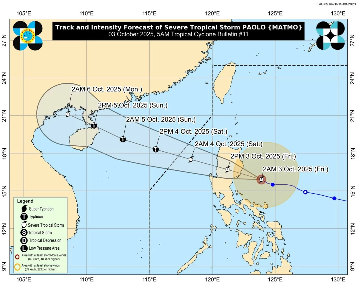
Severe Tropical Storm Paolo (international name: Matmo) further intensified as it moved closer to making landfall over the southern Isabela–northern Aurora area, the Philippine Atmospheric, Geophysical and Astronomical Services Administration (PAGASA) said on Friday morning, Oct. 3.
As of 5 a.m., the center of Paolo was located 150 kilometers east of Casiguran, Aurora, packing maximum sustained winds of 100 kilometers per hour (kph) near the center and gustiness of up to 125 kph. It was moving west-northwestward at 20 kph.
Wind signals up
Tropical Cyclone Wind Signal No. 3 has been raised over:
* Northern portion of Aurora (Dilasag, Casiguran, Dinalungan),
* Central and southern portions of Isabela (Dinapigue, San Mariano, San Guillermo, Echague, Jones, San Agustin, Cordon, City of Santiago, Ramon, San Isidro, Alicia, Angadanan, City of Cauayan, Benito Soliven, Naguilian, Luna, Reina Mercedes, Cabatuan, San Mateo, Aurora, San Manuel, Burgos, Gamu, Roxas, Palanan),
* Northern portion of Quirino (Maddela, Cabarroguis, Aglipay, Saguday, Diffun),
* Northern portion of Nueva Vizcaya (Diadi, Bagabag, Villaverde, Ambaguio, Quezon, Solano, Bayombong),
* Mountain Province, Ifugao, the southeastern portion of Abra (Tubo), the northern portion of Benguet (Mankayan, Buguias, Kabayan, Bakun, Kibungan, Atok, Kapangan),
* Central and southern portions of Ilocos Sur (Sugpon, Alilem, Cervantes, Suyo, Tagudin, Santa Cruz, Sigay, Quirino, Gregorio del Pilar, Salcedo, Santa Lucia, City of Candon, San Emilio, Galimuyod, Lidlidda, Banayoyo, Santiago, San Esteban, Burgos), and
* Northern portion of La Union (Sudipen, Santol, Balaoan, Luna, Bangar, San Gabriel, Bacnotan, San Juan).
Areas under Signal No. 2 are:
* Central and southern portions of mainland Cagayan (Peñablanca, Tuguegarao City, Enrile, Solana, Iguig, Tuao, Piat, Rizal, Santo Niño, Alcala, Amulung), the rest of Isabela, Quirino, and Nueva Vizcaya,
* Central portion of Aurora (Dipaculao, Baler, Maria Aurora, San Luis),
* Northern portion of Nueva Ecija (Carranglan, Bongabon, San Jose City, Pantabangan, Rizal, Lupao),
* Central and southern portions of Apayao (Conner, Kabugao), Kalinga, the rest of Abra and Benguet,
* Central and southern portions of Ilocos Norte (Nueva Era, Badoc, Pinili, City of Batac, Paoay, Currimao, Banna, Laoag City, San Nicolas, Sarrat, Dingras, Solsona, Marcos, Bacarra, Piddig),
* The rest of Ilocos Sur and La Union, and
* Northern portion of Pangasinan (San Fabian, Sison, Pozorrubio, Umingan, San Jacinto, Laoac, Binalonan, San Nicolas, Natividad, Tayug, San Manuel, Asingan, Santa Maria, San Quintin, Dagupan City, Mangaldan, Manaoag, Bolinao, Anda, Bani, City of Alaminos, Sual, Labrador, Lingayen, Binmaley, Calasiao, Mapandan, Santa Barbara, City of Urdaneta).
Areas under Signal No. 1 are:
* The rest of mainland Cagayan including Babuyan Islands, the rest of Aurora, the northern portion of Quezon (General Nakar, Infanta) including Polillo Islands, Camarines Norte, the northern portion of Camarines Sur (Siruma, Tinambac, Lagonoy, Garchitorena, Caramoan, Goa, San Jose, Presentacion), Catanduanes,
* The rest of Apayao, Ilocos Norte, Pangasinan, and Nueva Ecija,
* Northern portion of Bulacan (Doña Remedios Trinidad, San Miguel, San Ildefonso, Norzagaray, San Rafael), Tarlac,
* Northeastern portion of Pampanga (Magalang, Arayat, Candaba, Mabalacat City), and
* Northern portion of Zambales (Palauig, Masinloc, Candelaria, Santa Cruz).
Possible typhoon before landfall
PAGASA warned that Paolo may still reach typhoon category before landfall, which could mean raising of Signal No. 4 in some areas.
The storm is expected to make landfall in northern Aurora or southern Isabela this morning or around noon, it added.
Depending on the influence of a high-pressure area north of Paolo, a further southward shift in its track is possible.
After crossing Northern Luzon, Paolo is projected to emerge over the West Philippine Sea by Friday afternoon or evening and may further intensify into a typhoon before leaving the Philippine Area of Responsibilit by Saturday morning, Oct. 4.