


Manila Bulletin
 Philippines
National
'Paolo' may intensify into severe tropical storm ahead of landfall; Signal No. 3 or 4 may be raised
Philippines
National
'Paolo' may intensify into severe tropical storm ahead of landfall; Signal No. 3 or 4 may be raised
Philippines
National
'Paolo' may intensify into severe tropical storm ahead of landfall; Signal No. 3 or 4 may be raised
'Paolo' may intensify into severe tropical storm ahead of landfall; Signal No. 3 or 4 may be raised
Published Oct 2, 2025 12:22 pm
|
Updated Oct 2, 2025 08:04 pm


PAGASA
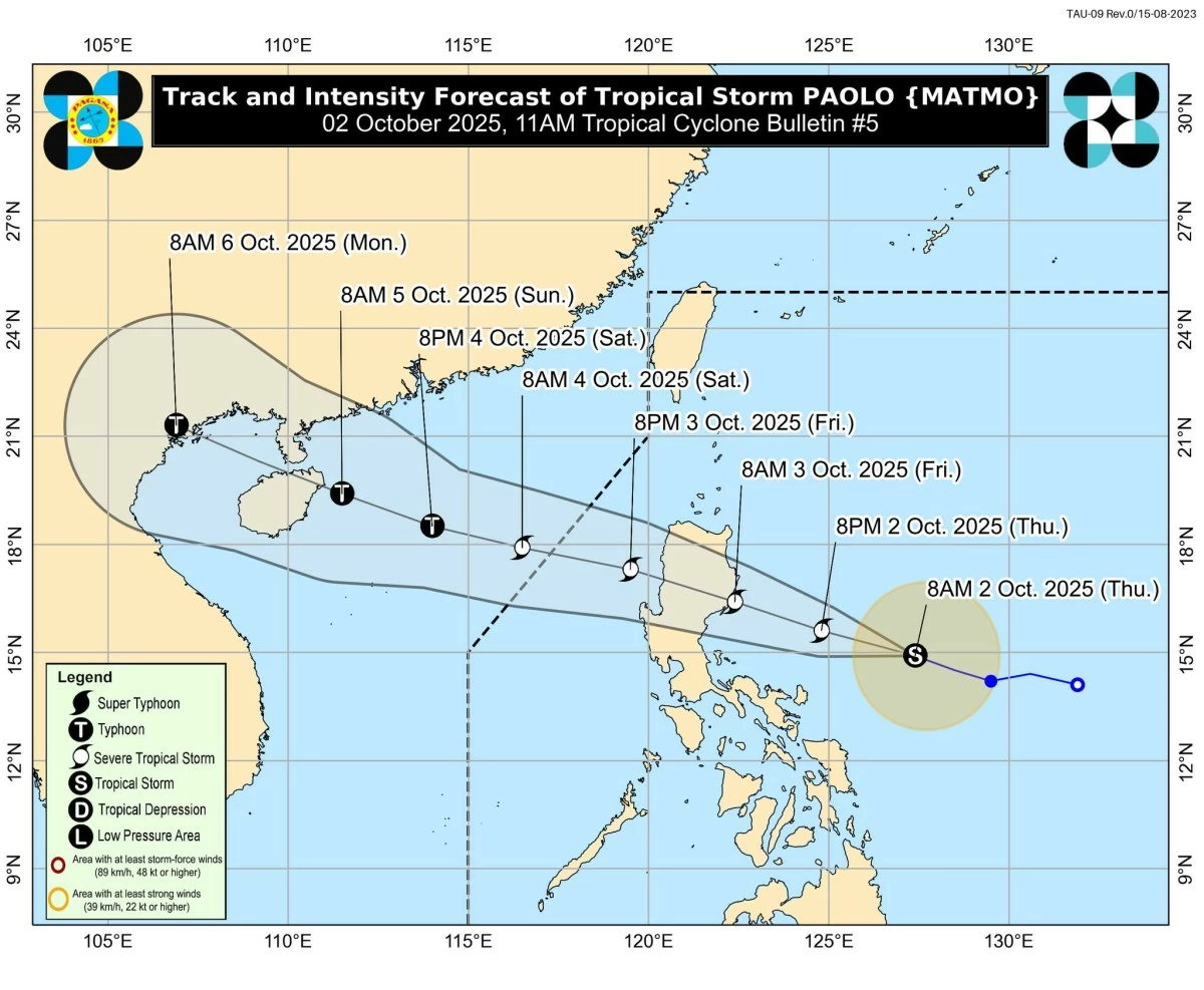
Tropical Storm Paolo (international name: Matmo) continues to intensify over the Philippine Sea and could reach severe tropical storm strength before making landfall over Isabela or Aurora by Friday, Oct. 3, the Philippine Atmospheric, Geophysical and Astronomical Services Administration (PAGASA) said Thursday, Oct. 2.
In its 11 a.m. bulletin, PAGASA said Paolo had slightly intensified, with maximum sustained winds of 75 kilometers per hour (kph) near the center and gusts of up to 90 kph.
It will be upgraded to a severe tropical storm once it reaches maximum winds of 87 kph.
“Paolo will continue to intensify while over the Philippine Sea and may reach severe tropical storm category tonight (Oct. 2). Further intensification into a typhoon prior to landfall is not ruled out,” PAGASA said.
“However, based on the intensity forecast, intensification into a typhoon is highly likely once Paolo emerges over the West Philippine Sea,” it added.
Forecast track
The center of the storm was located about 575 kilometers east of Infanta, Quezon, at 10 a.m.
If Paolo maintains its west-northwestward movement at 20 kph, it is expected to make landfall over southern Isabela or northern Aurora by Friday morning.
PAGASA pointed out that a southward shift in its track is possible depending on the strength of the high-pressure area located north of Paolo.
In a press conference on Thursday, PAGASA senior weather specialist Aldczar Aurelio added that the cyclone’s wide circulation means several areas in Northern and Central Luzon, as well as parts of Southern Luzon, could be affected.
After crossing Northern Luzon, Paolo will emerge over the West Philippine Sea on Friday afternoon and continue moving west-northwestward until it exits the Philippine Area of Responsibility by Saturday morning, Oct. 4.
Wind signals in effect
Tropical Cyclone Wind Signal No. 2 has been hoisted over the southeastern portion of Isabela (San Mariano, Dinapigue, San Guillermo, Echague, Jones, San Agustin, Benito Soliven, Angadanan, City of Cauayan, Naguilian), northern Quirino (Maddela), and northern Aurora (Dilasag, Casiguran, Dinalungan).
Winds of 62 to 88 kph may be expected in these areas within 24 hours.
Meanwhile, Signal No. 1 was raised over Cagayan, the rest of Isabela, the rest of Quirino, Nueva Vizcaya, Apayao, Abra, Kalinga, Mountain Province, Ifugao, Benguet, Ilocos Norte, Ilocos Sur, La Union, Pangasinan, northern portion of Zambales (Palauig, Masinloc, Candelaria, Santa Cruz), Tarlac, Nueva Ecija, the rest of Aurora, northern portion of Bulacan (Doña Remedios Trinidad, San Miguel, San Ildefonso, Norzagaray, San Rafael), northern portion of Pampanga (Magalang, Arayat, Candaba, Mabalacat City), northern portion of Quezon (General Nakar, Infanta), including Polillo Islands, northern portion of Camarines Norte (Capalonga, Jose Panganiban, Paracale, Vinzons, Talisay, Daet, Mercedes, Basud), northern portion of Camarines Sur (Siruma, Tinambac, Lagonoy, Garchitorena, Caramoan), and northern portion of Catanduanes (Pandan, Bagamanoc, Panganiban, Viga, Caramoran).
Winds of 39 to 61 kph may be expected in these areas within 36 hours.
PAGASA said the highest wind signal likely to be hoisted throughout Paolo’s passage is Signal No. 3.
Since the possibility of the storm reaching typhoon strength before landfall is not ruled out, the worst-case scenario is Signal No. 4.
Heavy rainfall outlook
From Thursday noon to Friday noon, intense to torrential rainfall (more than 200 millimeters) is forecast in Aurora, heavy to intense rainfall (100 to 200 millimeters) in Cagayan, Isabela, Quirino, Nueva Vizcaya, and Nueva Ecija, and moderate to heavy rainfall (50 to 100 millimeters) in Apayao, Kalinga, Mountain Province, Ifugao, Benguet, Pangasinan, Tarlac, Pampanga, Bulacan, Rizal, Quezon, Camarines Norte, Camarines Sur, Catanduanes, Albay, and Sorsogon.
From Friday noon to Saturday noon, intense to torrential rainfall is expected in La Union and Benguet, heavy to intense rainfall in Aurora, Isabela, Quirino, Nueva Vizcaya, Abra, Kalinga, Mountain Province, Ifugao, Pangasinan, Ilocos Sur, and Zambales, and moderate to heavy rainfall in Cagayan, Apayao, Ilocos Norte, Nueva Ecija, Tarlac, Bataan, Pampanga, and Bulacan.
Rain risks in quake-hit areas
PAGASA Deputy Administrator for Research and Development Dr. Marcelino Villafuerte also reminded residents in Masbate, Romblon, and northern Cebu, areas previously affected by the Sept. 30 earthquake, that even light to moderate rains may still pose additional risks.
He said rain could add weight to already weakened structures and warned that ignoring evacuation orders from local officials may lead to further casualties.
Villafuerte urged residents to heed the advice of their local governments and temporarily move to safer areas to avoid worsening the disaster situation.
Meanwhile, PAGASA-Weather Division chief Jun Galang pointed out that the southwest monsoon (habagat) has already weakened, with most of the rains now concentrated near Paolo’s center.
While further enhancement of the habagat is not expected, he said light to moderate rains in Metro Manila remain possible once the storm crosses Luzon.
Storm surge, gale warnings
PAGASA warned of a moderate risk of life-threatening storm surge, with peak heights reaching 1 to 2 meters within 36 hours over low-lying or exposed coastal areas of Ilocos Norte, Cagayan, Isabela, Aurora, Quezon, Camarines Norte, Camarines Sur, and Catanduanes.
Gale warnings may also be raised over the seaboards of Northern and Central Luzon due to rough to very rough sea conditions.
Mariners are advised to remain in port or seek shelter, and small vessels are warned not to venture out to sea.