


Manila Bulletin
 Philippines
National
'Opong' reintensifies over West Philippine Sea, to exit PAR on September 27 — PAGASA
Philippines
National
'Opong' reintensifies over West Philippine Sea, to exit PAR on September 27 — PAGASA
Philippines
National
'Opong' reintensifies over West Philippine Sea, to exit PAR on September 27 — PAGASA
'Opong' reintensifies over West Philippine Sea, to exit PAR on September 27 — PAGASA
Published Sep 27, 2025 07:54 am


Typhoon Opong (Bualoi) reintensifies over the West Philippine Sea and is expected to exit the Philippine Area of Responsibility (PAR) on September 27, 2025 according to PAGASA. Cloudy skies, scattered rains, and coastal hazards persist due to its trough and enhanced southwest monsoon. (PAGASA)
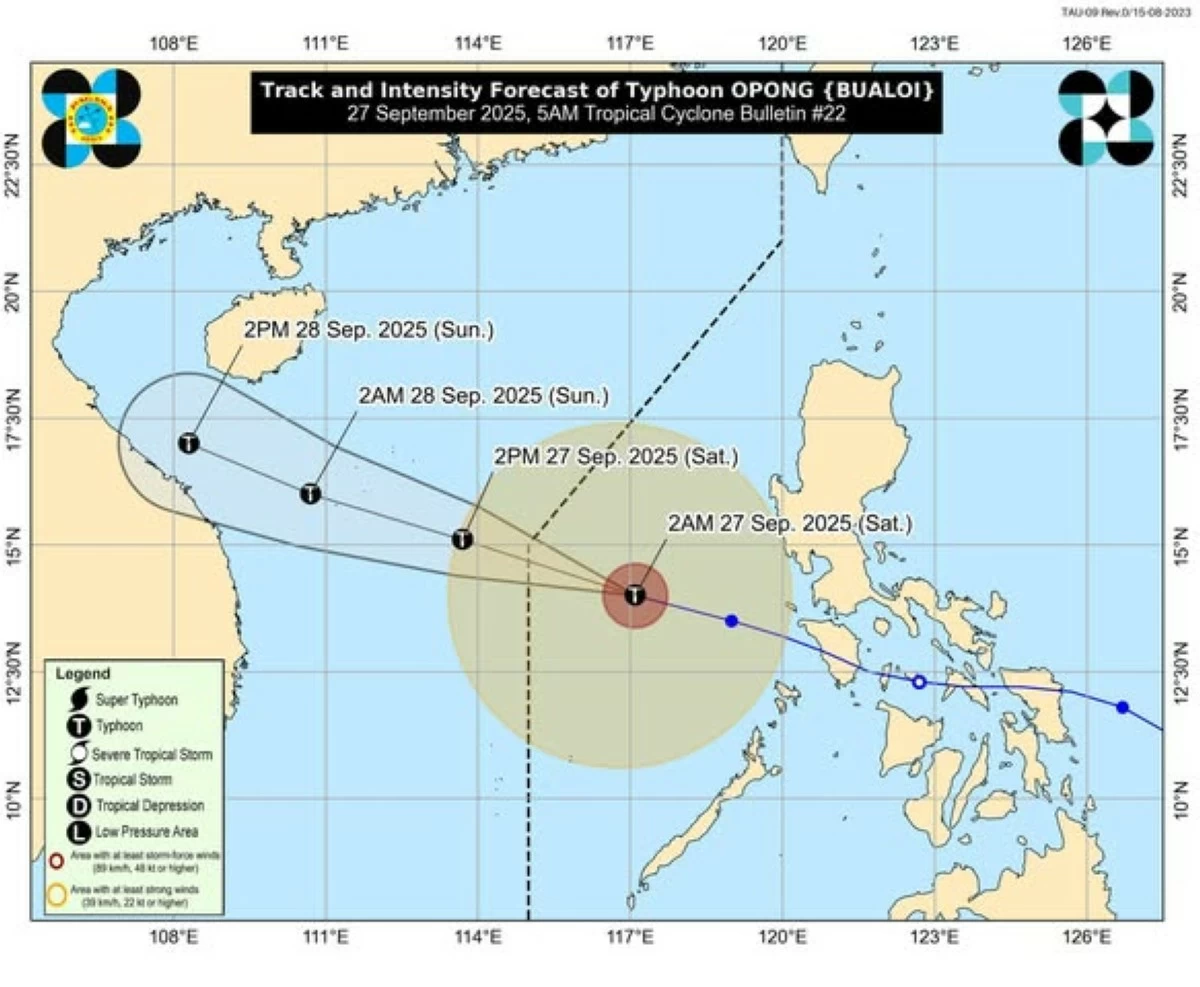
Typhoon Opong (international name: Bualoi) has reintensified while moving over the West Philippine Sea and is expected to exit the Philippine Area of Responsibility (PAR) this morning or early afternoon, Saturday, September 27, according to the Philippine Atmospheric, Geophysical and Astronomical Services Administration (PAGASA).
In a press briefing, PAGASA Weather Specialist Daniel James Villamil said that as of 4 a.m., the center of Opong was located 505 km west of Indang, Cavite, packing maximum sustained winds of 120 km/h near the center, gustiness of up to 150 km/h, and a central pressure of 970 hPa. It is moving west-northwestward at 30 km/h.
“Lumakas muli ito bilang isang typhoon dahil nandito na ito sa bahagi ng West Philippine Sea (It has intensified again into a typhoon now that it’s within the West Philippine Sea),” Villamil said. “Mababawasan na yung mga pag-ulan na mararanasan natin ngayong araw na dulot ng bagyong Opong (The rains brought by Typhoon Opong that we’re experiencing today will start to lessen),” he added.
‘Opong’ to exit PAR
On its track forecast, PAGASA said “Opong” will exit the PAR this morning or noon.
Outside the PAR, Villamil said Typhoon Opong is expected to move generally west northwestward towards northern Vietnam.
“Less likely na tayo makakaranas ng nung significant na malalakas na pag-ulan (We're less likely to experience significant heavy rainfall),” Villamil said. “Gayunpaman, may mga kaulapan na kasalukuyang uliiral sa ilang bahagi ng bansa na epekto ng extension or trough ni bagyong Opong (However, cloudy weather is experienced in some parts of the country due to the extension or trough of Typhoon Opong),” he added.
Enhanced ‘habagat’: Cloudy skies, scattered rains still expected
Despite moving away, PAGASA said “Opong” continues to bring cloudy skies, scattered rain showers, and thunderstorms in Metro Manila, Central Luzon, Ilocos Region, CALABARZON, and MIMAROPA due to its trough and enhanced southwest monsoon (habagat).
“For today, kahit papalayo na itong si Opong sa ating bansa, makakaranas pa rin tayo ng makulimlim na panahon at mga kalat-kalat ng pag-ulan at thunderstorms (The rest of the country will experience generally improved weather conditions with scattered rains),” Villamil said.
Villamil said the enhanced southwest monsoon and typhoon Opong’s trough will also bring rains and thunderstorms in several parts of the country.
Meanwhile, Villamil said PAGASA is also monitoring a cloud cluster east of the country that may develop into a low-pressure area (LPA) in the coming days.
Areas under Signal No. 1
With “Opong” expected to exit PAR, Villamil said PAGASA also lowered Tropical Cyclone Wind Signal (TCWS) warnings in certain areas.
“Nagbawas na din tayo ng TCWS sa ilang areas dahil wala nang sustained na hangin (The TCWS has been lifted in several areas, and there are no longer sustained strong winds), Villamil said.
As of 5 a.m., TCWS Signal No. 1 remains hoisted over the western portion of Pangasinan (Agno, Burgos, Dasol, Infanta, Mabini), Zambales, Bataan, the western portion of Cavite (Corregidor Island, Ternate, Maragondon, Magallanes), the western portion of Batangas (Nasugbu, Lian, Calatagan, Tuy, Balayan), the northern portion of Occidental Mindoro (Paluan, Mamburao, Abra de Ilog), including Lubang Islands, and Calamian Islands.
PAGASA said these areas may experience strong winds (39–61 km/h) with minimal to minor threats to life and property.
Coastal hazards, storm surge warning
“It must be emphasized that heavy rainfall, severe winds, and storm surge may still be experienced in localities outside the landfall point and the forecast confidence cone.
PAGASA said rough seas (up to 3.5 m) along the western seaboards of Zambales, Bataan, Occidental Mindoro, and northern Palawan, including Calamian Islands, while moderate to rough seas (up to 2.5 m) along the eastern seaboards of Quezon, Camarines provinces, Catanduanes, and western Palawan.
PAGASA warned small vessels and motorbancas not to venture into the sea due to risky wave conditions.
Meanwhile, PAGASA said a minimal to moderate risk of storm surge (1.0–2.0 m) remains possible within 12 hours in low-lying and coastal areas of Zambales, Bataan, Cavite, Batangas, Occidental Mindoro, and Palawan.
“Considering these developments, the public and disaster risk reduction and management offices concerned are advised to take all necessary measures to protect life and property,” PAGASA said.
READ:
https://mb.com.ph/2025/09/23/tropical-cyclone-opong-tracker