


Manila Bulletin
 Philippines
National
'Opong' may make another landfall over Oriental Mindoro — PAGASA
Philippines
National
'Opong' may make another landfall over Oriental Mindoro — PAGASA
Philippines
National
'Opong' may make another landfall over Oriental Mindoro — PAGASA
'Opong' may make another landfall over Oriental Mindoro — PAGASA
Heavy rains, strong winds, and storm surge possible in affected areas
Published Sep 26, 2025 12:03 pm
|
Updated Sep 26, 2025 01:22 pm


Heavy rain, flooding, and storm surges may threaten several Luzon and the Visayas areas as Severe Tropical Storm Opong is expected to make another landfall in Oriental Mindoro on September 26, 2025. (PAGASA)
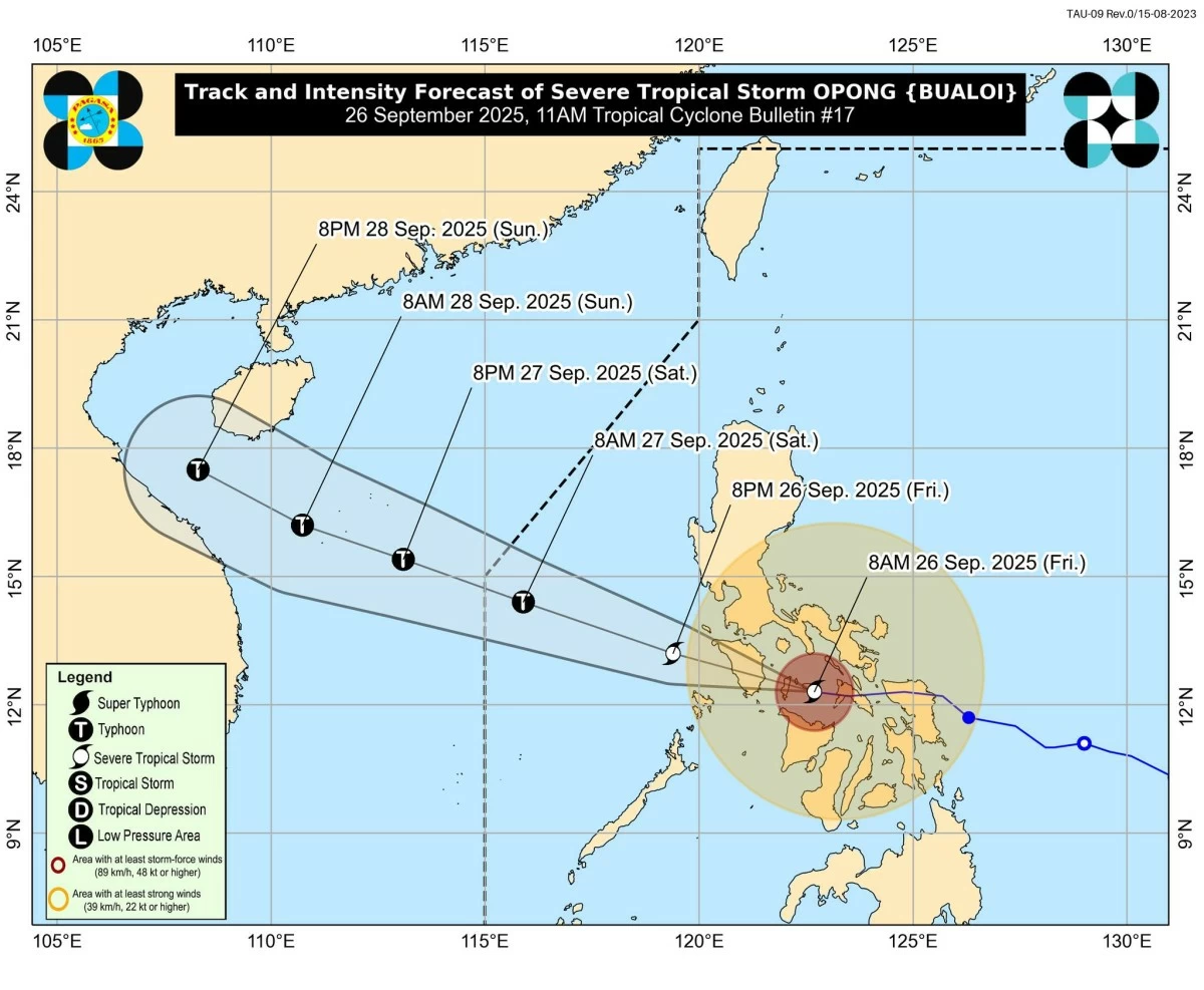
Severe Tropical Storm Opong (international name: Bualoi) is expected to make another landfall over Oriental Mindoro on Friday, September 26, after crossing Romblon, according to the Philippine Atmospheric, Geophysical and Astronomical Services Administration (PAGASA).
In its 11 a.m. bulletin, PAGASA said STS Opong had crossed Sibuyan and Tablas Islands in Romblon and is now moving toward the southern portion of Mindoro Island.
As of 10 a.m., PAGASA said the storm’s center was located over the coastal waters of Ferrol, Romblon.
“Opong” was packing maximum sustained winds of 110 km/h near the center, gusts of up to 150 km/h, and a central pressure of 985 hPa. PAGASA said it continues to move westward at 35 km/h.
Another landfall
PAGASA said that after making landfall in Romblon Friday morning, “Opong” is expected to make another landfall in Mindoro by noon or early afternoon.
“After making landfall over San Fernando, Romblon, and Alcantara, Romblon, at 8:10 a.m. and 9:20 a.m. today, respectively, Opong will continue moving west-northwestward and may make landfall over the southern portion of Oriental Mindoro by noon or early afternoon today,” PAGASA said.
PAGASA added that “Opong” will likely emerge over the Mindoro Strait tonight and head toward the West Philippine Sea, exiting the Philippine Area of Responsibility (PAR) by Saturday afternoon, September 27.
“Opong” will remain a severe tropical storm until it crosses Mindoro but may re-intensify over the West Philippine Sea, PAGASA said.
Intensity outlook, areas under wind signals
PAGASA raised the Tropical Cyclone Wind Signals (TCWS) in various areas in Luzon and Visayas.
Signal No. 3 (storm-force winds, 89–117 km/h):
Luzon - Batangas, Marinduque, Romblon, Occidental Mindoro, and Oriental Mindoro
Visayas - Northern portion of Aklan (Makato, Tangalan, Kalibo, New Washington, Ibajay, Lezo, Malay, Nabas, Numancia, Batan, Buruanga), and Caluya Island
Signal No. 2 (gale-force winds, 62–88 km/h):
Luzon - Southern portion of Zambales (San Marcelino, Subic, Olongapo City, Castillejos, San Antonio, San Narciso, San Felipe), Bataan, southern portion of Pampanga (Porac, Santa Rita, Guagua, Sasmuan, Macabebe, Masantol, Santo Tomas, San Simon, Minalin, City of San Fernando, Bacolor, Floridablanca, Apalit, Lubao), southern portion of Bulacan (Obando, Paombong, Bocaue, City of San Jose del Monte, Bustos, City of Malolos, City of Meycauayan, Balagtas, Guiguinto, Pandi, Plaridel, Calumpit, Santa Maria, Hagonoy, Baliuag, Bulacan, Marilao, Pulilan), Metro Manila, Rizal, Cavite, Laguna, southern portion of Quezon (Pitogo, Buenavista, Lucena City, Calauag, Pagbilao, Tiaong, Lopez, Catanauan, Mulanay, Guinayangan, Unisan, General Luna, Plaridel, Quezon, San Antonio, Alabat, Candelaria, Lucban, Sampaloc, Padre Burgos, Sariaya, City of Tayabas, Macalelon, Mauban, Dolores, Perez, Agdangan, Gumaca, Atimonan, Real, San Narciso, Tagkawayan, San Francisco, San Andres), southern portion of Camarines Sur (Ocampo, Milaor, Nabua, Buhi, Baao, Cabusao, Bato, Camaligan, Pili, Sipocot, Pamplona, Ragay, Iriga City, San Fernando, Magarao, Minalabac, Del Gallego, Balatan, Libmanan, Naga City, Bombon, Bula, Canaman, Pasacao, Sagñay, Gainza, Lupi), Albay, Sorsogon, Masbate, Calamian Islands, and Cuyo Islands
Visayas - Northern portion of Antique (Libertad, Pandan, Sebaste, Culasi, Valderrama, Barbaza, Tibiao, Patnongon, Laua-an, Bugasong), the rest of Aklan, Capiz, northern portion of Iloilo (Estancia, Carles, Balasan, Batad, San Dionisio, Concepcion, Sara, Ajuy, Lemery, Barotac Viejo, San Rafael, San Enrique, City of Passi, Bingawan, Calinog, Lambunao, Dueñas), northern portion of Negros Occidental (Manapla, City of Victorias, Enrique B. Magalona, Cadiz City, Sagay City), extreme northern portion of Cebu (Daanbantayan, Medellin) including Bantayan Islands, extreme western portion of Northern Samar (San Vicente, Capul, San Antonio), and extreme western portion of Samar (Tagapul-an)
Signal No. 1 (strong winds, 39–61 km/h):
Luzon - Pangasinan, rest of Zambales, Tarlac, Nueva Ecija, southern portion of Aurora (Dingalan, Baler, Maria Aurora, San Luis), rest of Pampanga, rest of Bulacan, rest of Quezon, Camarines Norte, rest of Camarines Sur, Catanduanes, northern portion of Palawan (El Nido, Taytay, Dumaran, Araceli, San Vicente, Roxas)
Visayas - Rest of Antique, rest of Iloilo, Guimaras, central portion of Negros Occidental (Calatrava, Salvador Benedicto, San Carlos City, Silay City, City of Talisay, Bacolod City, Bago City, Murcia, La Castellana, Valladolid, Pulupandan, La Carlota City, San Enrique, Pontevedra, Moises Padilla, Isabela, Hinigaran, City of Escalante, Toboso), northern portion of Negros Oriental (Vallehermoso, Canlaon City, City of Guihulngan), northern and central portion of Cebu (Asturias, Danao City, Compostela, Liloan, Consolacion, Cebu City, Balamban, Mandaue City, Lapu-Lapu City, Toledo City, City of Talisay, Pinamungahan, Minglanilla, City of Naga, San Fernando, Aloguinsan, Borbon, Carmen, Tuburan, City of Bogo, Tabogon, Catmon, Cordova, San Remigio, Sogod, Tabuelan, Barili, City of Carcar) including Camotes Islands, northern portion of Bohol (Getafe, Talibon, Bien Unido, Ubay, Trinidad, Pres. Carlos P. Garcia, Mabini, San Miguel, Alicia, Pilar, Dagohoy, Danao, Buenavista, Inabanga, Clarin, Sagbayan), rest of Northern Samar, rest of Samar, Eastern Samar, Biliran, Leyte, and Southern Leyte
“It must be emphasized that heavy rainfall, severe winds, and storm surge may still be experienced in localities outside the landfall point and the forecast confidence cone,” PAGASA said.
Heavy rain, flooding, and storm surge threat
PAGASA warned of moderate to heavy rainfall, severe winds, and life-threatening storm surges reaching 1.0 to 3.0 meters in coastal areas of Bataan, Pampanga, Bulacan, Metro Manila, Calabarzon, Mindoro, Marinduque, Romblon, Calamian Islands, Bicol Region, Northern Samar, Samar, Negros Occidental, Aklan, Antique, Capiz, and Iloilo.
The enhanced southwest monsoon (habagat) will also bring strong to gale-force winds over Luzon, Visayas, and parts of Mindanao, PAGASA said.
PAGASA also warned of hazardous sea conditions.
A gale warning is in effect as seas could reach up to 9.0 m over Romblon seaboards; up to 6.0 m over Batangas, Quezon, and Mindoro; and up to 4.5 m over Bicol, Western Visayas, Samar, Leyte, Negros, and nearby seaboards.
Sea travel is considered risky to dangerous for all vessels, PAGASA said.
PAGASA urged disaster risk reduction offices and local government units to implement preemptive evacuations in flood- and landslide-prone areas.
Residents were advised to stay alert for local government instructions and continue monitoring PAGASA bulletins.
READ: