


Manila Bulletin
 Philippines
National
Fewer areas under wind signals as 'Opong' moves over West Philippine Sea
Philippines
National
Fewer areas under wind signals as 'Opong' moves over West Philippine Sea
Philippines
National
Fewer areas under wind signals as 'Opong' moves over West Philippine Sea
Fewer areas under wind signals as 'Opong' moves over West Philippine Sea
Published Sep 26, 2025 08:37 pm


PAGASA
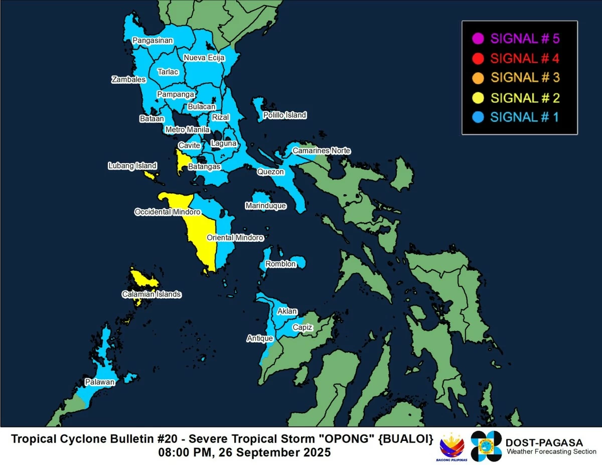
The Philippine Atmospheric, Geophysical and Astronomical Services Administration (PAGASA) on Friday, Sept. 26 said tropical cyclone wind warnings were lifted or downgraded in some areas as Severe Tropical Storm Opong (international name: Bualoi) moved over the West Philippine Sea.
According to PAGASA, Signal No. 3 has been lifted as of 8 p.m.
However, Signal No. 2 remains hoisted over the western portion of Batangas (Nasugbu, Tuy, Balayan, Lian, Calatagan, Calaca), Occidental Mindoro, and the Calamian Islands.
Meanwhile, Signal No. 1 is still in effect over Pangasinan, southern portion of Aurora (Dingalan, Baler, Maria Aurora, San Luis), Nueva Ecija, Tarlac, Zambales, Bataan, Pampanga, Bulacan, Metro Manila, Rizal, Cavite, Laguna, the rest of Batangas, Quezon, western portion of Camarines Norte, Marinduque, Romblon, Oriental Mindoro, and northern portion of Palawan (Dumaran, San Vicente, Roxas, Taytay, Araceli, El Nido), including Cuyo Islands, Aklan, northern portion of Antique (Patnongon, Barbaza, Pandan, San Jose, Bugasong, Culasi, Sebaste, Tibiao, Belison, Laua-An, Libertad), including Caluya Islands, and western portion of Capiz (Sapi-An, Tapaz, Mambusao, Jamindan).
PAGASA reminded residents in areas still under wind signals to remain cautious of strong winds, heavy rains, and rough coastal waters as Opong continues to enhance the southwest monsoon or “habagat.”
As of 7 p.m., the center of Opong was located 215 kilometers west of Calapan City, Oriental Mindoro.
The storm was moving west northwestward at 30 kilometers per hour (kph), with maximum sustained winds of 110 kph near the center and gustiness of up to 135 kph.
PAGASA said Opong may reintensify into a typhoon within the next 12 hours while heading toward northern Vietnam.
It is expected to exit the Philippine Area of Responsibility (PAR) by Saturday morning, Sept. 27.