


Manila Bulletin
 Philippines
National
'Opong' still likely to hit Bicol as typhoon; Signal No. 3 raised over parts of Samar Island
Philippines
National
'Opong' still likely to hit Bicol as typhoon; Signal No. 3 raised over parts of Samar Island
Philippines
National
'Opong' still likely to hit Bicol as typhoon; Signal No. 3 raised over parts of Samar Island
'Opong' still likely to hit Bicol as typhoon; Signal No. 3 raised over parts of Samar Island
Storm's center to be closest to Metro Manila Friday afternoon to evening
Published Sep 25, 2025 03:00 pm


PAGASA
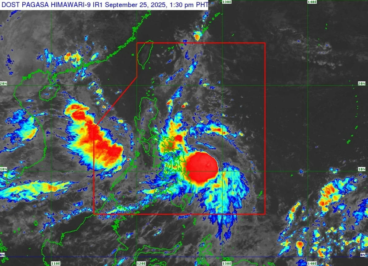
Severe Tropical Storm Opong (international name: Bualoi) is still on track to slam into the Bicol Region as a typhoon by Friday, Sept. 26, prompting the Philippine Atmospheric, Geophysical and Astronomical Services Administration to raise Tropical Cyclone Wind Signal No. 3 over parts of Samar Island on Thursday afternoon, Sept. 25.
As of 1 p.m., the center of Opong was estimated at 300 kilometers east of Guiuan, Eastern Samar.
It packed maximum sustained winds of 110 kilometers per hour (kph) near the center and gustiness of up to 135 kph, while moving west at 15 kph.
Forecast track, intensity
PAGASA said Opong may reach typhoon intensity before making landfall over Bicol Region on Friday.
It is then expected to weaken as it crosses Southern Luzon but will likely remain a typhoon or be downgraded into a severe tropical storm during its passage.
Re-intensification is highly likely once Opong emerges over the West Philippine Sea before exiting the Philippine Area of Responsibility by Saturday afternoon or evening, Sept. 27.
PAGASA weather specialist Benison Estareja said the center of Opong may pass very close to the coast of Northern Samar early Friday morning.
By late morning until midday, the storm is forecast to cross the Bicol Region, then traverse the Quezon-Marinduque area from midday to afternoon.
In the afternoon to evening, Opong’s center will be at its closest to Metro Manila, with Calabarzon, northern part of Marinduque, and Mindoro directly affected by the typhoon’s eyewall.
By late evening until early Saturday, the storm will begin to move away from land and head toward the West Philippine Sea, where it is projected to leave PAR by Saturday afternoon.
Opong currently has a circulation spanning 850 to 900 kilometers, with a radius of about 430 kilometers.
Estareja said this wide coverage means the areas under its center and eyewall will bear the brunt of the strongest winds and heaviest rains, while its outer rainbands will also affect the Caraga Region, much of the Visayas, Palawan, the northern portion of Central Luzon, as well as the southern parts of Cagayan Valley and the Cordillera Administrative Region, and Ilocos Region.
Wind signals
PAGASA said the highest Wind Signal that may be hoisted during the passage of Opong is Signal No. 4.
As of Thursday afternoon, Signal No. 3 is in effect over the northern and eastern portions of Northern Samar (Gamay, Lapinig, Mapanas, Palapag, Laoang, San Roque, Pambujan, and Catubig), and the northern portion of Eastern Samar (San Policarpo, Arteche, Jipapad, and Oras).
These areas may experience storm-force winds within 18 hours that could bring a moderate to significant threat to life and property.
Signal No. 2 is up over the southern portion of Quezon (Tagkawayan, Guinayangan, Calauag, Lopez, San Andres, Mulanay, San Narciso, San Francisco, Buenavista, Catanauan, General Luna, Macalelon), eastern portion of Marinduque (Santa Cruz, Torrijos), northeastern portion of Romblon (Cajidiocan, Magdiwang, Banton, Romblon, Corcuera), Camarines Norte, Camarines Sur, Catanduanes, Albay, Sorsogon, Masbate, the rest of Northern Samar, central portion of Eastern Samar (Can-Avid, Maslog, Taft, Dolores, Sulat, San Julian, Borongan City, Maydolong), northern and central portions of Samar (San Jorge, San Sebastian, Villareal, Zumarraga, Matuguinao, Pinabacdao, Almagro, Calbayog City, Talalora, Jiabong, Pagsanghan, Catbalogan City, Gandara, Motiong, Santo Niño, Tagapul-An, San Jose de Buan, Santa Margarita, Tarangnan, Calbiga, Daram, Paranas, Hinabangan), Biliran, and northern portion of Leyte (Calubian).
These areas may experience gale-force winds of 62 to 88 kilometers per hour within 24 hours, which could cause light damage to houses made of light materials, broken branches of trees, and disruption of power lines.
In Luzon, Signal No. 1 is in effect over the central and southern portions of Isabela (Alicia, San Mateo, Aurora, Ramon, Naguilian, Dinapigue, San Guillermo, Luna, Cauayan City, Echague, Angadanan, Benito Soliven, Santiago City, Reina Mercedes, San Agustin, San Manuel, Cabatuan, Gamu, San Isidro, Cordon, Jones, Burgos, San Mariano, Palanan), Quirino, Nueva Vizcaya, Ifugao, the southwestern portion of Mountain Province (Bauko, Sabangan, Tadian), Benguet, southern portion of Ilocos Sur (Sugpon, Alilem), La Union, Pangasinan, Aurora, Nueva Ecija, Tarlac, Zambales, Bataan, Pampanga, Bulacan, Metro Manila, Rizal, Cavite, Batangas, Laguna, the rest of Quezon, the rest of Romblon, the rest of Marinduque, Occidental Mindoro, Oriental Mindoro, and Calamian Islands.
In the Visayas, Signal No. 1 covers the rest of Eastern Samar, the rest of Samar, the rest of Leyte, Southern Leyte, northern portion of Cebu (Daanbantayan, Medellin, Bogo City, Tabogon, San Remigio, Borbon, Sogod, Tabuelan, Catmon, Tuburan, Carmen, Danao City, Asturias, Compostela), Bantayan Island, Camotes Islands, northern portion of Negros Occidental (Escalante City, Toboso, Calatrava, Sagay City, Cadiz City, Manapla, Victorias City, Enrique B. Magalona, Silay City, Talisay City), northern portion of Iloilo (San Dionisio, Batad, Balasan, Carles, Sara, Concepcion, Ajuy, Lemery, Barotac Viejo, San Rafael, Banate, Anilao, San Enrique, Passi City, Bingawan, Calinog, Lambunao, Dueñas, Dingle), Capiz, Aklan, and northern portion of Antique (Libertad, Pandan, Sebaste, Culasi, Tibiao, Barbaza, Bugasong, Laua-An, Caluya).
In Mindanao, Signal No. 1 is raised over Siargao Island, Bucas Grande Islands, and Dinagat Islands.
Winds of 39 to 61 kilometers per hour are expected in these areas within 36 hours, posing a minimal to minor threat to life and property such as damage to light structures and unsafe sea travel for small vessels.
Brace for heavy rains, storm surges
Aside from damaging winds, the storm is expected to bring heavy rainfall across Bicol, Eastern Visayas, and parts of Southern Luzon.
PAGASA warned that Opong would bring heavy to intense rains (100 to 200 millimeters) over Northern Samar, Eastern Samar, Sorsogon, Masbate, Samar, and Biliran on Thursday.
Meanwhile, moderate to heavy rains (50 to 100 mm) may affect Catanduanes, Leyte, Southern Leyte, and Dinagat Islands.
On Friday, intense to torrential rains (more than 200 mm) may prevail over Sorsogon, Masbate, Northern Samar, Eastern Samar, Albay, Quezon, and Marinduque.
Heavy to intense rainfall may affect Laguna, Batangas, Oriental Mindoro, Camarines Norte, Camarines Sur, Catanduanes, Samar, and Biliran, while moderate to heavy rains may persist in Metro Manila, Zambales, Bataan, Pangasinan, Cagayan, Isabela, Aurora, Quirino, Nueva Vizcaya, Nueva Ecija, Bulacan, Pampanga, Tarlac, Cavite, Rizal, Occidental Mindoro, Romblon, Aklan, Capiz, Cebu, Southern Leyte, and Leyte.
By Saturday, moderate to heavy rainfall may prevail over Metro Manila, Zambales, Bataan, Cavite, Batangas, and Occidental Mindoro.
The southwest monsoon (habagat), enhanced by Opong, may also bring moderate to heavy rains over Zambales, Bataan, and Occidental Mindoro on Thursday.
On Friday, moderate to heavy precipitation may prevail over Palawan, Antique, Iloilo, Guimaras, Negros Occidental, and Negros Oriental.
By Saturday, moderate to heavy rainfall may persist in Palawan, Antique, Aklan, and Negros Occidental.
PAGASA also raised storm surge warnings of one to three meters over low-lying and coastal areas in Metro Manila, Central Luzon, Calabarzon, Mimaropa, Bicol, Northern Samar, Eastern Samar, Samar, Biliran, and Leyte within 36 hours.
The weather bureau advised residents of affected areas to prepare for severe winds, heavy rainfall, flooding, landslides, and coastal inundation, while fisherfolk and small vessels were urged not to venture into the eastern seaboards where sea conditions remain very rough to high.