


Manila Bulletin
 Philippines
National
'Opong' landfall seen in Northern or Eastern Samar, Sorsogon before crossing S. Luzon
Philippines
National
'Opong' landfall seen in Northern or Eastern Samar, Sorsogon before crossing S. Luzon
Philippines
National
'Opong' landfall seen in Northern or Eastern Samar, Sorsogon before crossing S. Luzon
'Opong' landfall seen in Northern or Eastern Samar, Sorsogon before crossing S. Luzon
Stormy weather expected in Bicol, Eastern Visayas — PAGASA
Published Sep 25, 2025 05:45 pm


PAGASA
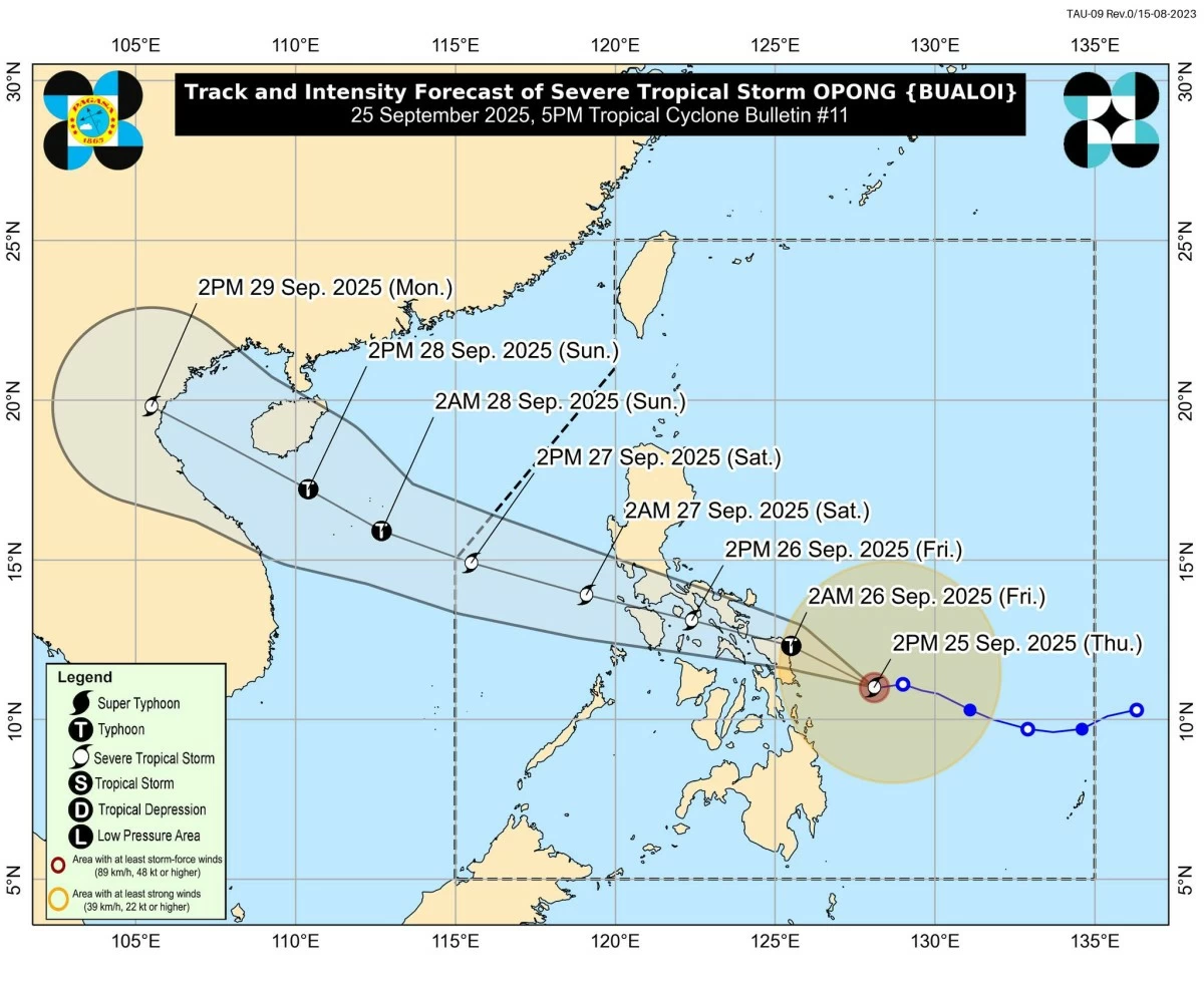
Severe Tropical Storm Opong (international name: Bualoi) is expected to make its first landfall over Northern Samar or the northern portion of Eastern Samar early Friday, Sept. 26, before hitting Sorsogon later in the day, the Philippine Atmospheric, Geophysical and Astronomical Services Administration (PAGASA) said Thursday, Sept. 25.
After its landfalls, Opong will move west-northwestward near or over the Sibuyan Sea, crossing the mainland and island provinces of Bicol Region, southern Calabarzon, and northern Mimaropa.
It is projected to exit into the West Philippine Sea by early Saturday, Sept. 27.
PAGASA said Opong may reach typhoon category before landfall and weaken while crossing Southern Luzon. However, it will likely remain a typhoon or severe tropical storm.
Re-intensification is highly likely once it reaches the West Philippine Sea.
Heavy rains, strong winds
PAGASA warned of a stormy weather on Friday over Bicol Region, Northern Samar, Eastern Samar, Samar, Biliran, Marinduque, Romblon, and Quezon.
Heavy to intense rains could trigger floods and landslides, while strong to gale-force winds may pose a minor to moderate threat to life and property.
Rains with gusty winds will also prevail over Metro Manila, Central Luzon, Calabarzon, Isabela, Quirino, Nueva Vizcaya, Cordillera Administrative Region, Ilocos Sur, La Union, Pangasinan, Oriental Mindoro, Occidental Mindoro, Aklan, Capiz, Antique, Iloilo, Negros Occidental, Cebu, Leyte, Southern Leyte, and Dinagat Islands.
Zamboanga Peninsula, Northern Mindanao, the rest of Caraga, the rest of Visayas, and Palawan will have occasional rains due to the southwest monsoon or “habagat.”
The rest of Luzon will experience scattered rains and thunderstorms, while the rest of Mindanao will remain partly cloudy to cloudy with isolated rain showers or thunderstorms.
As of 4 p.m. Thursday, Sept. 25, Opong was located 195 kilometers east of Guiuan, Eastern Samar, or 225 km east of Borongan City.
It had maximum sustained winds of 110 kilometers per hour (kph) near the center, gusts of up to 135 kph, and was moving westward at 15 kph.
Wind signals
PAGASA said the highest Tropical Cyclone Wind Signal that may be hoisted during Opong’s passage is Signal No. 4.
Areas under Signal No. 3 may experience storm-force winds of 89 to 117 kph within 18 hours, posing a moderate to significant threat to life and property.
These include Sorsogon, the northern portion of Masbate, including Ticao and Burias Islands, Northern Samar, northern portion of Eastern Samar, and northern portion of Samar.
Areas under Signal No. 2 will experience gale-force winds of 62 to 88 kph within 24 hours, which may cause minor to moderate impacts.
These are the eastern portion of Batangas, southern portion of Quezon, Camarines Norte, Camarines Sur, Albay, Catanduanes, the rest of Masbate, Marinduque, Romblon, Oriental Mindoro, central portions of Eastern Samar and Samar, Biliran, and northwestern portion of Leyte.
Signal No. 1, which may bring strong winds of 39 to 61 kph within 36 hours, has been raised over central and southern Isabela, Quirino, Nueva Vizcaya, Ifugao, parts of Mountain Province and Ilocos Sur, Benguet, La Union, Pangasinan, Aurora, Nueva Ecija, Tarlac, Zambales, Bataan, Pampanga, Bulacan, Metro Manila, Rizal, Cavite, the rest of Batangas, Laguna, the rest of Quezon, Occidental Mindoro, Cuyo Islands, Calamian Islands, the rest of Eastern Samar, the rest of Samar, the rest of Leyte, Southern Leyte, northern Cebu, including Bantayan and Camotes Islands, northern Negros Occidental, northern Iloilo, Capiz, Aklan, northern Antique, Siargao Island, Bucas Grande Islands, and Dinagat Islands.