


Manila Bulletin
 Philippines
National
Tropical depression Opong enters PAR; may cross E. Visayas, S. Luzon this weekend
Philippines
National
Tropical depression Opong enters PAR; may cross E. Visayas, S. Luzon this weekend
Philippines
National
Tropical depression Opong enters PAR; may cross E. Visayas, S. Luzon this weekend
Tropical depression Opong enters PAR; may cross E. Visayas, S. Luzon this weekend
It may pass close to or make landfall in N. Samar by Sept. 26
Published Sep 23, 2025 05:35 pm


PAGASA
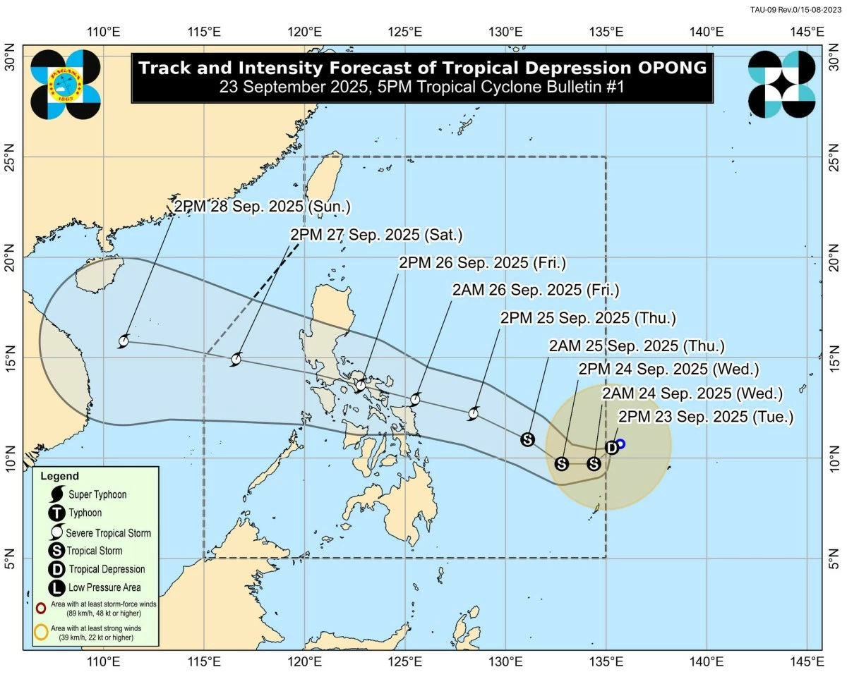
The tropical depression spotted east of Mindanao has entered the Philippine Area of Responsibility (PAR) on Tuesday afternoon, Sept. 23, and was given the local name “Opong,” the Philippine Atmospheric, Geophysical and Astronomical Services Administration (PAGASA) said.
As of 4 p.m., the center of Opong was located 1,045 kilometers east of northeastern Mindanao.
It has maximum sustained winds of 55 kilometers per hour (kph) near the center and gustiness of up to 70 kph.
Opong was moving west-southwestward at 10 kph.
While no tropical cyclone wind signal has been raised yet, PAGASA said Signal No. 1 may be hoisted over parts of Eastern Visayas and Bicol Region as early as Wednesday, Sept. 24.
The highest signal that may be issued during its passage is Signal No. 3, as Opong could strengthen into a severe tropical storm by Thursday afternoon, Sept. 25.
PAGASA said the tropical depression is less likely to directly affect the country within the next 36 hours, but rains associated with Opong may begin affecting parts of Eastern Visayas and Bicol starting Thursday.
Coastal flooding due to possible storm surges may also occur in low-lying areas along Southern Luzon and Eastern Visayas.
It added that moderate to rough seas are expected over the coastal waters of Eastern Visayas and Northeastern Mindanao by Thursday afternoon.
On its forecast track, Opong may move southwestward in the next 24 hours before turning west-northwestward toward the Eastern Visayas–Southern Luzon area.
PAGASA said the weather disturbance may pass close to or make landfall over Northern Samar by early Friday, Sept. 26, and cross Southern Luzon until Friday evening or early Saturday, Sept. 27.
Further intensification, especially after crossing land, remains possible, it added.