


Manila Bulletin
 Philippines
National
Tropical depression develops east of Visayas, to enter PAR soon
Philippines
National
Tropical depression develops east of Visayas, to enter PAR soon
Philippines
National
Tropical depression develops east of Visayas, to enter PAR soon
Tropical depression develops east of Visayas, to enter PAR soon
Published Sep 23, 2025 12:38 pm
|
Updated Sep 23, 2025 02:35 pm


PAGASA
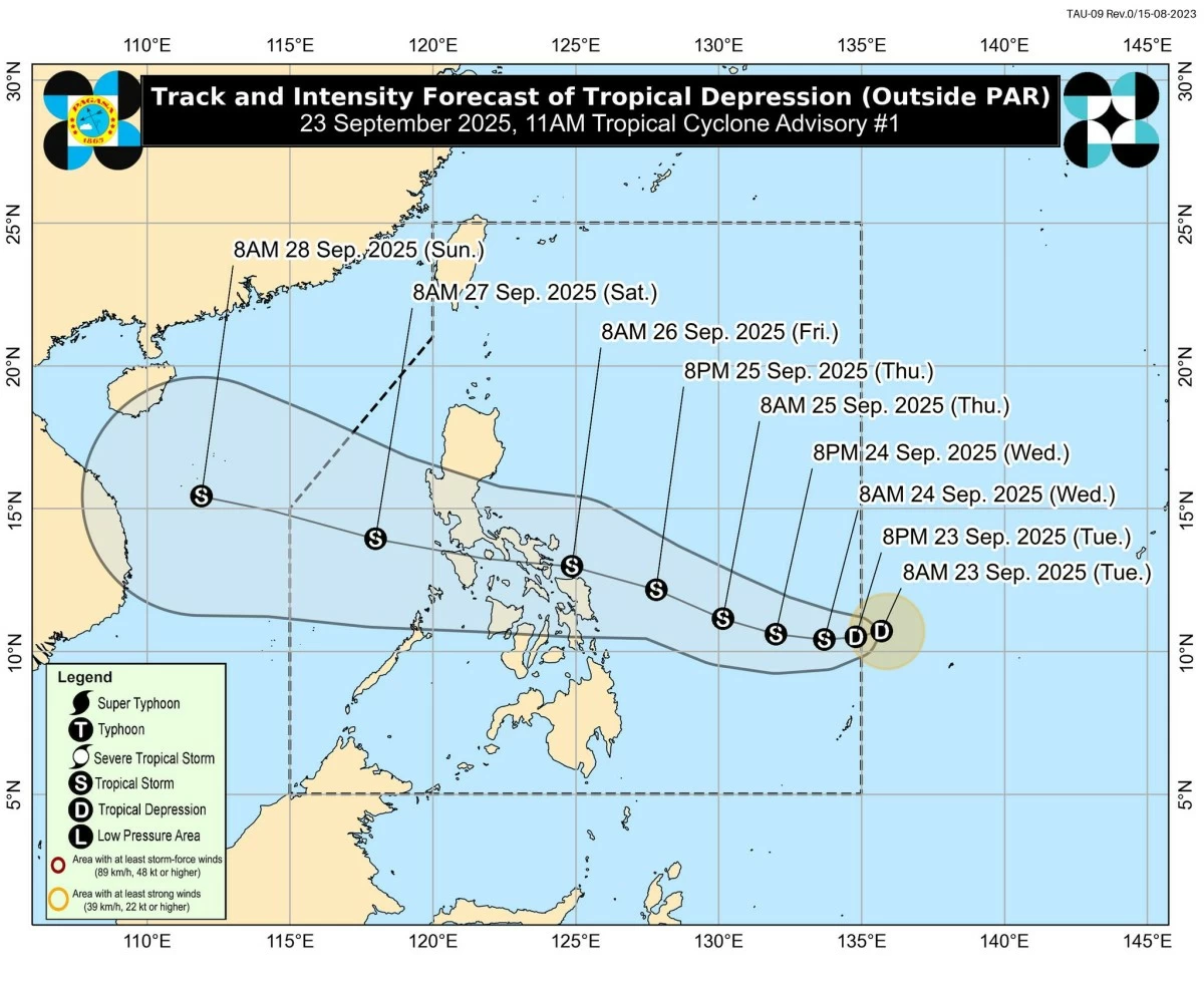
The low-pressure area (LPA) east of Eastern Visayas developed into a tropical depression on Tuesday morning, Sept. 23, as Super Typhoon Nando (international name: Ragasa) left the Philippine area of responsibility (PAR), the Philippine Atmospheric, Geophysical and Astronomical Services Administration (PAGASA) said.
As of 10 a.m., the center of the tropical depression was located 1,075 kilometers east of Eastern Visayas, with maximum sustained winds of 55 kilometers per hour (kph) near the center and gusts of up to 70 kph.
It is moving west at 35 kph.
PAGASA said the tropical depression is expected to enter the PAR this afternoon or evening and will be given the local name “Opong.”
Once inside, it is seen to move west-northwestward toward the Eastern Visayas–Southern Luzon area and may cross Bicol Region, Calabarzon, and Mimaropa between Friday, Sept. 26, and Saturday, Sept. 27, before possibly exiting PAR by Saturday evening.
The weather disturbance is expected to gradually intensify over the Philippine Sea and may reach tropical storm category by Wednesday, Sept. 24.
Based on PAGASA’s forecast, Tropical Cyclone Wind Signal No. 1 may be hoisted Eastern Visayas as early as Wednesday, with the possibility of higher signals, up to Signal No. 3, if the system strengthens further.
While still outside PAR, the tropical depression is unlikely to directly affect local weather and sea conditions within the next 36 hours.
Heavy rains from the cyclone may begin affecting areas by Thursday, Sept. 25.
PAGASA also warned of moderate to rough seas over the coastal waters of Eastern Visayas and northeastern Mindanao starting Thursday afternoon.
A gale warning may be issued over the seaboards of Eastern Visayas and Bicol Region by Thursday in anticipation of rough to very rough conditions.