


Manila Bulletin
 Philippines
National
'Nando' maintains strength over West Philippine Sea; Signal No. 2 still up
Philippines
National
'Nando' maintains strength over West Philippine Sea; Signal No. 2 still up
Philippines
National
'Nando' maintains strength over West Philippine Sea; Signal No. 2 still up
'Nando' maintains strength over West Philippine Sea; Signal No. 2 still up
Published Sep 23, 2025 01:19 pm


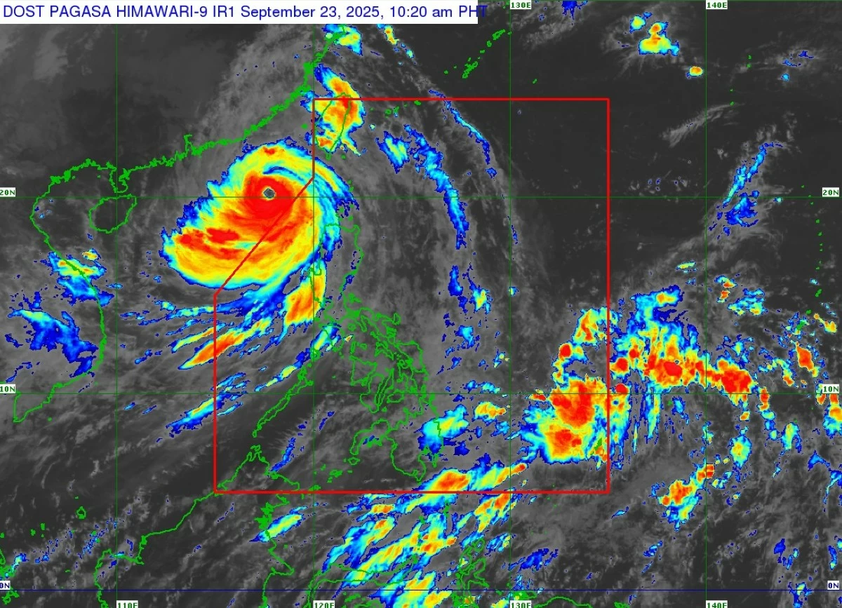
Super Typhoon Ragasa (formerly “Nando”) maintained its strength on Tuesday morning, Sept. 23, as it continued to move west-northwestward over the West Philippine Sea, the Philippine Atmospheric, Geophysical and Astronomical Services Administration (PAGASA) said.
As of 10 a.m., the eye of Ragasa was located 385 kilometers west-northwest of Calayan, Cagayan, or 425 km west of Basco, Batanes, outside the Philippine Area of Responsibility (PAR).
READ MORE:
It packed maximum sustained winds of 185 kilometers per hour (kph) near the center and gustiness of up to 230 kph, while moving west-northwestward at 20 kph.
Signal No. 2 remains hoisted over the western portion of Babuyan Islands (Calayan, Panuitan, Dalupiri, Irao, Mabag, Barit, and Fuga), northwestern portion of mainland Cagayan (Claveria, Sanchez-Mira, Santa Praxedes), northern portion of Apayao (Calanasan), and Ilocos Norte.
Signal No. 1 is up over Batanes, the rest of Babuyan Islands, the rest of mainland Cagayan, northern portion of Isabela (San Manuel, Roxas, Mallig, Quezon, Santa Maria, Cabagan, Santo Tomas, Delfin Albano, Quirino, Tumauini, San Pablo, Maconacon), the rest of Apayao, Abra, Kalinga, Mountain Province, Ifugao, Benguet, Ilocos Sur, La Union, and northwestern portion of Pangasinan (Bolinao, Anda, Agno, Dasol, Sual, Burgos, Alaminos City, Bani, Mabini).
All wind signals are expected to be lifted within the day, PAGASA said.
While Ragasa is already outside the PAR, it is still enhancing the southwest monsoon or “habagat.”
Heavy to intense rains (100-200 mm) may prevail over La Union, Pangasinan, Benguet, Zambales, and Bataan from today until Wednesday noon, and moderate to heavy rains (50-100 mm) in Ilocos Norte, Ilocos Sur, Tarlac, Pampanga, Cavite, Batangas, and Occidental Mindoro.
From Wednesday noon to Thursday noon, Sept. 25, moderate to heavy rains may persist in Zambales, Bataan, and Occidental Mindoro.
Ragasa is expected to continue to move west-northwestward over the West Philippine Sea in the next 24 hours before turning more westward over waters south of mainland China.
It may make landfall over southern China by Wednesday evening, Sept. 24, or early Thursday, Sept. 25.
PAGASA said the typhoon is expected to maintain its strength within the day before weakening as it nears the southern coast of China.