


Manila Bulletin
 Philippines
National
'Nando' exits Philippine area of responsibility; Signal No. 3 still up in 3 areas
Philippines
National
'Nando' exits Philippine area of responsibility; Signal No. 3 still up in 3 areas
Philippines
National
'Nando' exits Philippine area of responsibility; Signal No. 3 still up in 3 areas
'Nando' exits Philippine area of responsibility; Signal No. 3 still up in 3 areas
Published Sep 23, 2025 07:21 am


PAGASA
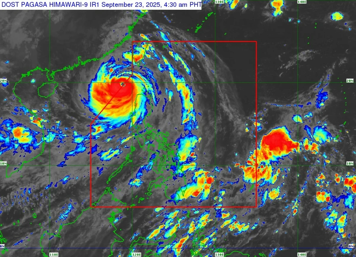
Super Typhoon “Nando” (international name: Ragasa) left the Philippine area of responsibility (PAR) at 5 a.m. Tuesday, Sept. 23, but three areas in Northern Luzon remain under Tropical Cyclone Wind Signal No. 3, said the Philippine Atmospheric, Geophysical and Astronomical Services Administration (PAGASA).
PAGASA weather specialist Obet Badrina said the center of the eye of Nando was located 265 kilometers west of Calayan, Cagayan at 4 a.m., moving westward at 20 kilometers per hour (kph)
It had maximum sustained winds of 185 kph near the center and gusts of up to 230 kph.
Wind signals still raised
Signal No. 3 remains hoisted over Ilocos Norte, northwestern portion of Apayao (Calanasan), and northwestern portion of mainland Cagayan (Sanchez Mira, Santa Praxedes, Claveria), including the western portion of Babuyan Islands (Panuitan, Calayan, Dalupiri, Mabaag, Barit, and Fuga Islands).
Areas under Signal No. 2 are Batanes, the rest of the Babuyan Islands, northern and central portions of Cagayan (Iguig, Solana, Tuao, Baggao, Amulung, Piat, Santa Ana, Gattaran, Lal-lo, Gonzaga, Pamplona, Abulug, Ballesteros, Aparri, Camalaniugan, Buguey, Santa Teresita, Allacapan, Lasam, Santo Niño, Alcala, and Rizal), the rest of Apayao, Abra, Kalinga, western portion of Mountain Province (Besao, Tadian, Sagada, Bauko, Sadanga, Bontoc, Sabangan), northern portion of Benguet (Mankayan, Bakun), Ilocos Sur, and northern portion of La Union (Sudipen, Bangar, Luna, Balaoan, Santol).
Signal No. 1 remains in effect over the rest of Cagayan, Isabela, Quirino, Nueva Vizcaya, northern and central portions of Aurora (Dilasag, Casiguran, Dinalungan, Dipaculao, Maria Aurora), the rest of Mountain Province, Ifugao, the rest of Benguet, the rest of La Union, Pangasinan, northern portion of Zambales (Santa Cruz, Candelaria, Masinloc, Iba, Palauig), northern and central portions of Tarlac (Paniqui, La Paz, Moncada, City of Tarlac, San Jose, Gerona, Mayantoc, Pura, San Clemente, Santa Ignacia, Victoria, Camiling, Ramos, San Manuel, Anao), and the northern and central portions of Nueva Ecija (Cuyapo, Talavera, Santo Domingo, Rizal, Zaragoza, Llanera, Guimba, Aliaga, Pantabangan, Science City of Muñoz, General Mamerto Natividad, Carranglan, Quezon, San Jose City, Lupao, Nampicuan, Talugtug, Licab, Bongabon).
Heavy rainfall outlook
Badrina said that although Nando has exited PAR, heavy rainfall will continue to affect several areas.
Due to the tropical cyclone, 100 to 200 millimeters of rain (heavy to intense) are expected on Tuesday over Ilocos Norte, Ilocos Sur, La Union, Abra, and Benguet.
Rainfall of 50 to 100 mm (moderate to heavy) is also likely over Batanes, Cagayan, Apayao, Kalinga, Mountain Province, Ifugao, Nueva Vizcaya, Pangasinan, and Zambales.
By Wednesday, Sept. 24, 50 to 100 mm of rain may still prevail in Ilocos Norte and Ilocos Sur.
Meanwhile, the southwest monsoon (habagat) enhanced by the typhoon may bring 50 to 100 mm of rainfall on Tuesday over Bataan, Batangas, and Occidental Mindoro, and on Wednesday over La Union, Pangasinan, Benguet, Zambales, Bataan, and Occidental Mindoro.
New weather system may enter PAR
Badrina added that a low-pressure area (LPA) outside PAR, located about 1,205 kilometers east of Eastern Visayas, may enter the country’s area of responsibility today.
The LPA has a high chance of developing into a tropical depression within 24 hours and may be named “Opong” once it intensifies into a cyclone.