


Signal No. 5 up as 'Nando' moves closer to Babuyan Islands
Published Sep 22, 2025 06:20 am


PAGASA
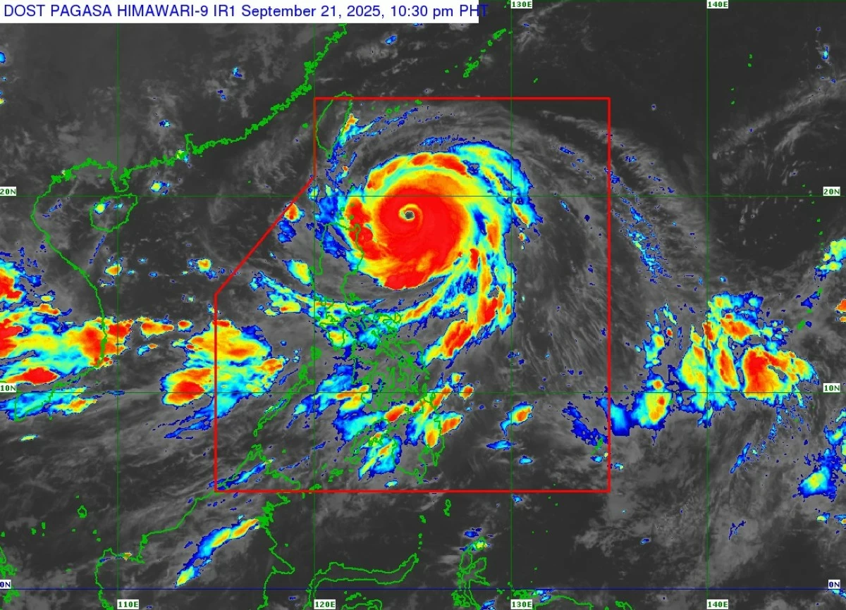
The Philippine Atmospheric, Geophysical and Astronomical Services Administration (PAGASA) raised Tropical Cyclone Wind Signal No. 5 early Monday, Sept. 22, over parts of Babuyan Islands as Super Typhoon Nando (international name: Ragasa) moved closer to Northern Luzon.
As of 4 a.m., the center of the eye of Nando was estimated 245 kilometers east of Calayan, Cagayan, packing maximum sustained winds of 205 kilometers per hour (kph) near the center and gusts of up to 250 kph.
It was moving west-northwestward at 20 kph.
PAGASA raised Signal No. 5 over the northern portion of the Babuyan Islands (Babuyan, Didicas, Panuitan, and Calayan Islands).
Signal No. 4 was hoisted over the southeastern portion of Batanes (Basco, Mahatao, Ivana, Uyugan, and Sabtang; the rest of the Babuyan Islands), and the northeastern portion of mainland Cagayan (Santa Ana).
Areas under Signal No. 3 are the rest of Batanes; the northern and central portions of mainland Cagayan (Gonzaga, Lal-Lo, Gattaran, Baggao, Alcala, Santo Niño, Lasam, Allacapan, Camalaniugan, Buguey, Sta. Teresita, Aparri, Ballesteros, Abulug, Pamplona, Sanchez-Mira, Claveria, Sta. Praxedes, Rizal, Amulung, and Piat), northern and central portions of Apayao (Flora, Sta. Marcela, Pudtol, Luna, Calanasan, and Kabugao); and northern and central portions of Ilocos Norte (Carasi, Piddig, Vintar, Bacarra, Pasuquin, Burgos, Bangui, Dumalneg, Pagudpud, Adams, Nueva Era, Solsona, Dingras, Sarrat, Laoag City, San Nicolas, Currimao, Paoay, Batac City, Marcos, and Banna).
Under Signal No. 2 are the rest of Cagayan; Isabela; the rest of Apayao; Abra; Kalinga; Mountain Province; Ifugao; the northern portion of Benguet (Mankayan, Buguias, Bakun, and Kibungan); northeastern portion of Nueva Vizcaya (Diadi); the rest of Ilocos Norte; Ilocos Sur; and the northern portion of La Union (Sudipen, Bangar, Luna, Balaoan, and Santol).
Meanwhile, Signal No. 1 was in effect over Quirino; the rest of Nueva Vizcaya; the rest of Benguet; the rest of La Union; Pangasinan; Aurora; Nueva Ecija; Bulacan; Tarlac; Pampanga; Zambales; and the northern portion of Quezon (General Nakar and Polillo Islands).
PAGASA also warned of a high risk of life-threatening storm surges exceeding three meters in low-lying or exposed coastal areas of Batanes, Cagayan including the Babuyan Islands, Ilocos Norte, and Ilocos Sur. Seas may reach up to 14 meters over the seaboards of Batanes and Babuyan Islands, 12 meters over the northern coast of Ilocos Norte, and 10 meters over the northern coast of mainland Cagayan, making sea travel extremely dangerous.
PAGASA said Nando will bring more than 200 millimeters (mm) of rain today, considered intense to torrential, over Batanes, Cagayan, Ilocos Norte, Ilocos Sur, Abra, and Apayao.
Rainfall of 100 to 200 mm (heavy to intense) is also expected in La Union, Kalinga, and Isabela, while 50 to 100 mm (moderate to heavy) may affect Pangasinan, Benguet, Mountain Province, Ifugao, Nueva Vizcaya, Nueva Ecija, Tarlac, Pampanga, Bulacan, and Zambales.
By Tuesday, Sept. 23, rainfall of 50 to 100 mm is forecast in Batanes, Ilocos Norte, Apayao, Abra, Cagayan, Ilocos Sur, La Union, Pangasinan, Benguet, Mountain Province, Kalinga, and Ifugao.
Meanwhile, the southwest monsoon enhanced by Nando will bring 100 to 200 mm of rain today over Occidental Mindoro, and 50 to 100 mm over Metro Manila, Bataan, Cavite, Batangas, Laguna, Rizal, Oriental Mindoro, and Palawan.
On Tuesday, moderate to heavy rains (50–100 mm) may affect Metro Manila, Bataan, Zambales, Bulacan, Pampanga, Cavite, Batangas, Occidental Mindoro, and Palawan.
By Wednesday, Sept. 24, similar rainfall amounts are expected in Pangasinan, Zambales, Bataan, and Occidental Mindoro.
On its forecast track, Nando may pass close to or make landfall over the Babuyan Islands between noon and early afternoon Monday, and exit the Philippine Area of Responsibility by Tuesday morning.