


Manila Bulletin
 Philippines
National
'Nando' to exit PAR Sept 23, but may continue to enhance 'habagat'
Philippines
National
'Nando' to exit PAR Sept 23, but may continue to enhance 'habagat'
Philippines
National
'Nando' to exit PAR Sept 23, but may continue to enhance 'habagat'
'Nando' to exit PAR Sept 23, but may continue to enhance 'habagat'
Published Sep 22, 2025 08:57 pm


PAGASA
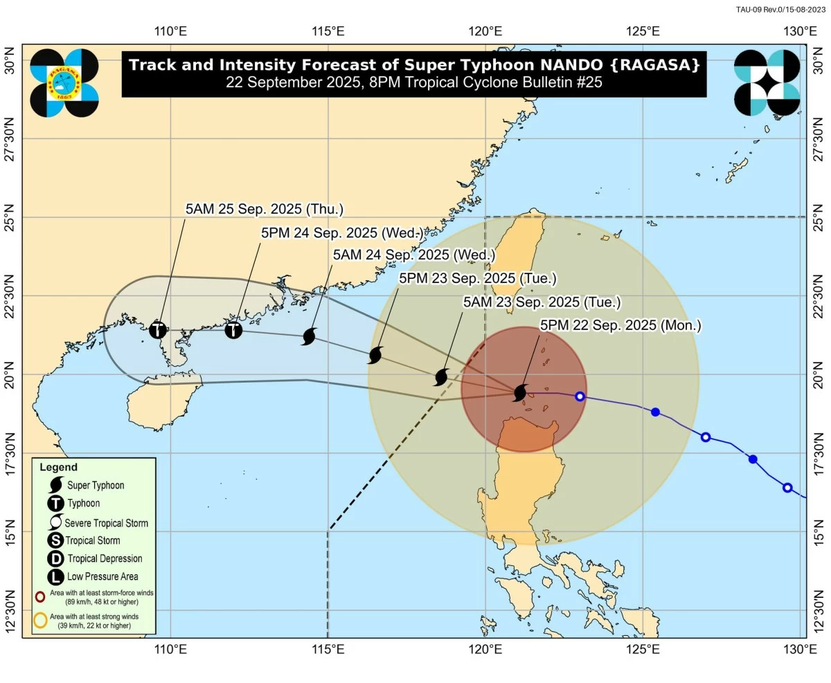
Super Typhoon Nando (international name: Ragasa) began to move away from Northern Luzon on Monday evening, Sept. 22, and is expected to exit the Philippine Area of Responsibility (PAR) by Tuesday morning, Sept. 23, said the Philippine Atmospheric, Geophysical and Astronomical Services Administration (PAGASA).
However, the weather bureau said it may continue to enhance the southwest monsoon or “habagat.”
As of 7 p.m., the eye of Nando was located 85 kilometers west-northwest of Calayan, Cagayan.
It was packing maximum sustained winds of 215 kilometers per hour (kph) near the center and gusts of up to 265 kph, while moving west at 20 kph.
PAGASA said Tropical Cyclone Wind Signal No. 5 has been lifted, with Signal No. 4 now the highest raised.
Signal No. 4 is up over Babuyan Islands, northwestern Cagayan (Santa Praxedes, Claveria, Sanchez-Mira, Pamplona), and northern Ilocos Norte (Pagudpud, Burgos, Bangui, Dumalneg, Adams).
Signal No. 3 is in effect over Batanes, the rest of Cagayan (Lal-Lo, Gattaran, Baggao, Alcala, Santo Niño, Lasam, Allacapan, Rizal, Amulung, Piat, Ballesteros, Abulug, Aparri, Santa Teresita, Buguey, Santa Ana, Camalaniugan, Gonzaga), the rest of Ilocos Norte, and northern and central portions of Apayao (Flora, Santa Marcela, Pudtol, Luna, Calanasan, Kabugao).
Signal No. 2 is raised over the rest of Apayao, Abra, Kalinga, Mountain Province, Ifugao, northern portion of Benguet (Mankayan, Buguias, Bakun, Kibungan), Ilocos Sur, northern portion of La Union (Sudipen, Bangar, Luna, Balaoan, Santol), and northern portion of Isabela (Santo Tomas, San Mateo, Aurora, Santa Maria, Quezon, Roxas, Luna, Delfin Albano, San Pablo, Ilagan City, Tumauini, Cabagan, Reina Mercedes, San Manuel, Cabatuan, Quirino, Divilacan, Gamu, Mallig, Maconacon, Burgos).
Signal No. 1 is hoisted over the rest of Isabela, Quirino, Nueva Vizcaya, the rest of Benguet, the rest of La Union, Pangasinan, Aurora, Nueva Ecija, Bulacan, Tarlac, Pampanga, Zambales, and northern portion of Quezon (General Nakar), including Polillo Islands.
Rainfall outlook
PAGASA said Nando will bring more than 200 millimeters of rain (intense to torrential) over Ilocos Norte, Ilocos Sur, La Union, and Benguet from Monday night until Tuesday evening.
Between 100 and 200 mm of rain (heavy to intense) are expected over Batanes, Cagayan, Apayao, and Abra, while 50 to 100 mm (moderate to heavy) are possible over Kalinga, Mountain Province, Ifugao, Nueva Vizcaya, Pangasinan, and Zambales.
From Tuesday evening to Wednesday evening, Sept. 24, rains of 50 to 100 mm are still likely over Ilocos Norte, Ilocos Sur, and Benguet.
The habagat, enhanced by Nando, will also bring 50 to 100 mm of rain over Metro Manila, Bataan, Cavite, Laguna, Batangas, Rizal, and Occidental Mindoro until Tuesday evening.
From Tuesday evening to Wednesday evening, moderate to heavy rains may continue to affect La Union, Pangasinan, Zambales, Bataan, and Occidental Mindoro.
Other hazards
PAGASA continues to warn of life-threatening storm surges exceeding three meters over the low-lying and exposed coastal areas of Batanes, Cagayan including Babuyan Islands, Ilocos Norte, and Ilocos Sur.
Very rough to very high seas of up to 14 meters are also expected over the northern seaboards of Northern Luzon, with sea travel deemed risky for all vessels.
Gale warnings were raised over the seaboards of Aurora, Zambales, Bataan, Lubang Island, Occidental Mindoro, and nearby waters.