


Manila Bulletin
 Philippines
National
'Nando' keeps strengthening as it veers west; Babuyan Islands remain at risk
Philippines
National
'Nando' keeps strengthening as it veers west; Babuyan Islands remain at risk
Philippines
National
'Nando' keeps strengthening as it veers west; Babuyan Islands remain at risk
'Nando' keeps strengthening as it veers west; Babuyan Islands remain at risk
Published Sep 22, 2025 08:17 am


PAGASA
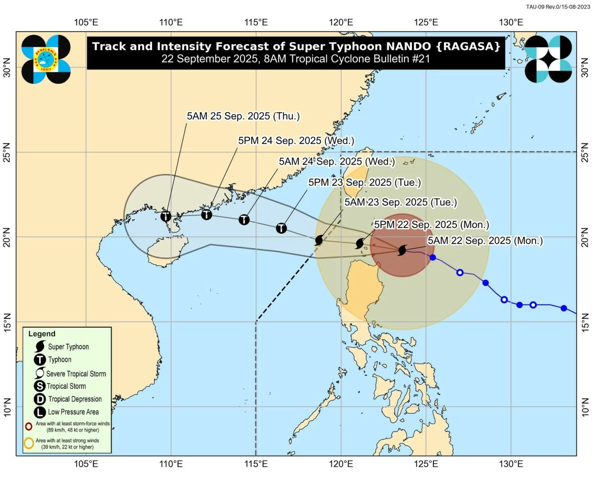
Super Typhoon Nando (international name: Ragasa) intensified further on Monday morning, Sept. 22, as it moved westward toward the Babuyan Islands, where it may pass close to or make landfall around midday, the Philippine Atmospheric, Geophysical and Astronomical Services Administration (PAGASA) said.
As of 7 a.m., the center of the eye of Nando was located 180 kilometers east of Calayan, Cagayan, based on data from the Aparri Doppler Weather Radar.
It was packing maximum sustained winds of 215 kilometers per hour (kph) near the center and gusts of up to 265 kph.
Before further strengthening, Nando was packing maximum sustained winds of 205 kph and gusts of up to 250 kph.
PAGASA raised Signal No. 5 over the northern and central portions of the Babuyan Islands (Babuyan, Didicas, Panuitan, Calayan, Dalupri, Irao, Camiguin, and Pamuktan).
Signal No. 4 was in effect over southeastern Batanes (Basco, Mahatao, Ivana, Uyugan, and Sabtang); the rest of the Babuyan Islands; northeastern and northwestern mainland Cagayan (Sta. Ana, Sta. Praxedes, Claveria, and Sanchez-Mira); and the northernmost town of Ilocos Norte (Pagudpud).
Signal No. 3 was raised over the rest of Batanes; northern and central portions of mainland Cagayan (Gonzaga, Lal-lo, Gattaran, Baggao, Alcala, Sto. Niño, Lasam, Allacapan, Camalaniugan, Buguey, Sta. Teresita, Aparri, Ballesteros, Abulug, Pamplona, Rizal, Amulung, and Piat); northern and central portions of Apayao (Flora, Sta. Marcela, Pudtol, Luna, Calanasan, and Kabugao); and northern and central portions of Ilocos Norte (Laoag City, Batac, Burgos, Pasuquin, Bangui, Adams, Carasi, Piddig, Vintar, Bacarra, Dumalneg, Nueva Era, Solsona, Dingras, Sarrat, San Nicolas, Currimao, Paoay, Marcos, and Banna).
Signal No. 2 was hoisted over the rest of Cagayan, Isabela, the rest of Apayao, Abra, Kalinga, Mountain Province, Ifugao, northern Benguet (Mankayan, Buguias, Bakun, and Kibungan), northeastern Nueva Vizcaya (Diadi), the rest of Ilocos Norte, Ilocos Sur, and northern La Union (Sudipen, Bangar, Luna, and Balaoan).
Signal No. 1 covered Quirino, the rest of Nueva Vizcaya, Benguet, La Union, Pangasinan, Aurora, Nueva Ecija, Bulacan, Tarlac, Pampanga, Zambales, and northern Quezon (General Nakar, including the Polillo Islands).
PAGASA warned of torrential rains in Batanes, Cagayan, Apayao, and Ilocos Norte; intense rains in Ilocos Sur, Abra, and Kalinga; and heavy rains in La Union, Benguet, Mountain Province, Ifugao, Isabela, and Nueva Vizcaya.
Seas are forecast to be very rough to high, with waves reaching up to 14 meters along the seaboards of Batanes and the Babuyan Islands, 12 meters along the northern coast of Ilocos Norte, and 10 meters along the northern coast of mainland Cagayan.
PAGASA advised that sea travel is extremely dangerous for all vessels.
On its forecast track, Nando may exit the Philippine Area of Responsibility by Tuesday morning, Sept. 23, while possibly maintaining or even intensifying further as it moves into the West Philippine Sea.