


Manila Bulletin
 Philippines
National
Parts of Batanes, Cagayan placed under Signal No. 3 as 'Nando' moves closer to extreme Northern Luzon
Philippines
National
Parts of Batanes, Cagayan placed under Signal No. 3 as 'Nando' moves closer to extreme Northern Luzon
Philippines
National
Parts of Batanes, Cagayan placed under Signal No. 3 as 'Nando' moves closer to extreme Northern Luzon
Parts of Batanes, Cagayan placed under Signal No. 3 as 'Nando' moves closer to extreme Northern Luzon
Published Sep 21, 2025 05:37 pm


PAGASA
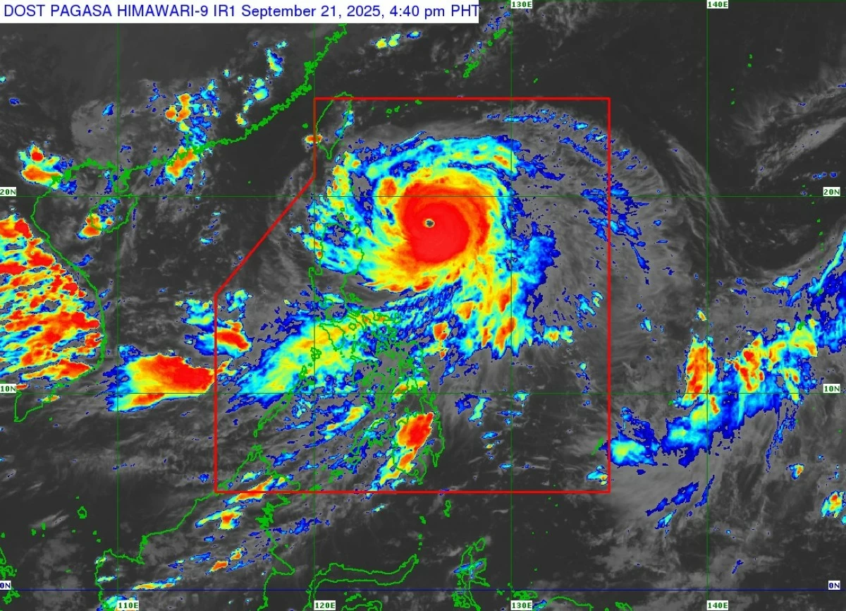
The Philippine Atmospheric, Geophysical and Astronomical Services Administration (PAGASA) raised Tropical Cyclone Wind Signal No. 3 over parts of Batanes and Cagayan on Sunday afternoon, Sept. 21, as super typhoon “Nando” (international name: Ragasa) continued to move closer to extreme Northern Luzon.
As of 5 p.m., Nando was packing maximum sustained winds of 185 kilometers per hour (kph) near the center and gusts of up to 230 kph. Its center was located 450 kilometers east of Aparri, Cagayan, moving west-northwest at 15 kph.
Wind signals
PAGASA said Signal No. 3 is in effect over the southern portion of Batanes (Mahatao, Uyugan, Basco, Ivana, Sabtang), the Babuyan Islands, and the northeastern portion of mainland Cagayan (Santa Ana).
Signal No. 2 was hoisted over the rest of Batanes, the rest of mainland Cagayan, the northern and eastern portions of Isabela (San Mariano, Ilagan City, Tumauini, Cabagan, Palanan, Divilacan, Maconacon, San Pablo, Santa Maria, Santo Tomas, Delfin Albano, Quezon, Quirino, Mallig, Roxas, Gamu), Apayao, Abra, Kalinga, the eastern portion of Mountain Province (Paracelis), Ilocos Norte, and the northern portion of Ilocos Sur (Cabugao, Sinait, San Juan, Magsingal, Santo Domingo, Bantay, San Ildefonso, San Vicente, Santa Catalina, City of Vigan, Caoayan, Santa, Nagbukel, Narvacan, Santa Maria).
Meanwhile, Signal No. 1 was raised over the rest of Isabela, Quirino, Nueva Vizcaya, the rest of Mountain Province, Ifugao, Benguet, the rest of Ilocos Sur, La Union, Pangasinan, the northern and central portions of Zambales ( Santa Cruz, Candelaria, Masinloc, Iba, Palauig, Cabangan, Botolan), Nueva Ecija, Tarlac, Aurora, the northern portion of Pampanga ( Mabalacat City, Magalang, Arayat, Candaba, Angeles City, Porac, Mexico, Santa Ana, San Luis, City of San Fernando, Bacolor), the northern portion of Bulacan ( Doña Remedios Trinidad, San Ildefonso, San Miguel, San Rafael), and the northern portion of Quezon ( General Nakar) including Polillo Islands.
PAGASA warned that areas under Signal No. 3 may experience moderate to significant impacts from storm-force winds, while those under Signal No. 2 and Signal No. 1 may feel moderate to minor impacts.
The highest possible signal that may be raised during Nando’s passage is Signal No. 5.
The state weather bureau also warned of a high risk of life-threatening storm surges exceeding three meters in low-lying and exposed coastal areas of Batanes, Cagayan, including Babuyan Islands, Ilocos Norte, and Ilocos Sur, within the next 48 hours.
Rainfall forecast
From Sunday to Monday afternoon, Sept. 22, intense to torrential rains are expected in Batanes, Cagayan, and Apayao; heavy to intense rains in Abra and Ilocos Norte; and moderate to heavy rains in Ilocos Sur, La Union, Benguet, Kalinga, Mountain Province, and Zambales.
From Monday afternoon to Tuesday afternoon, Sept. 23, Ilocos Norte, Apayao, and Abra may experience intense to torrential rains, while heavy to intense rains may fall in Batanes, Cagayan, Ilocos Sur, La Union, Benguet, and Kalinga. Moderate to heavy rains are likely in Pangasinan, Mountain Province, Ifugao, Isabela, Nueva Vizcaya, Nueva Ecija, Zambales, and Tarlac.
From Tuesday afternoon to Wednesday afternoon, Sept. 24, moderate to heavy rains are possible in Batanes, Cagayan, Ilocos Norte, Ilocos Sur, Apayao, and Abra.
The enhanced southwest monsoon (habagat) will also bring heavy to intense rains over Occidental Mindoro, and moderate to heavy rains over parts of Southern Luzon, Western Visayas, and Metro Manila until midweek.
Track, intensity forecast
PAGASA said Nando will continue to move west-northwestward before turning westward toward extreme Northern Luzon.
It may pass close to or make landfall over Batanes or the Babuyan Islands by Monday afternoon or evening, and exit the Philippine area of responsibility by early Tuesday.
The super typhoon is expected to intensify further before its approach to extreme Northern Luzon, PAGASA added.