


Manila Bulletin
 Philippines
National
Typhoon Nando intensifies: PAGASA warns of storm surges; Signal No. 1 raised in N. Luzon areas
Philippines
National
Typhoon Nando intensifies: PAGASA warns of storm surges; Signal No. 1 raised in N. Luzon areas
Philippines
National
Typhoon Nando intensifies: PAGASA warns of storm surges; Signal No. 1 raised in N. Luzon areas
Typhoon Nando intensifies: PAGASA warns of storm surges; Signal No. 1 raised in N. Luzon areas
'Habagat' to persist, bringing rains and possible flooding in several areas, including Metro Manila
Published Sep 20, 2025 11:27 pm


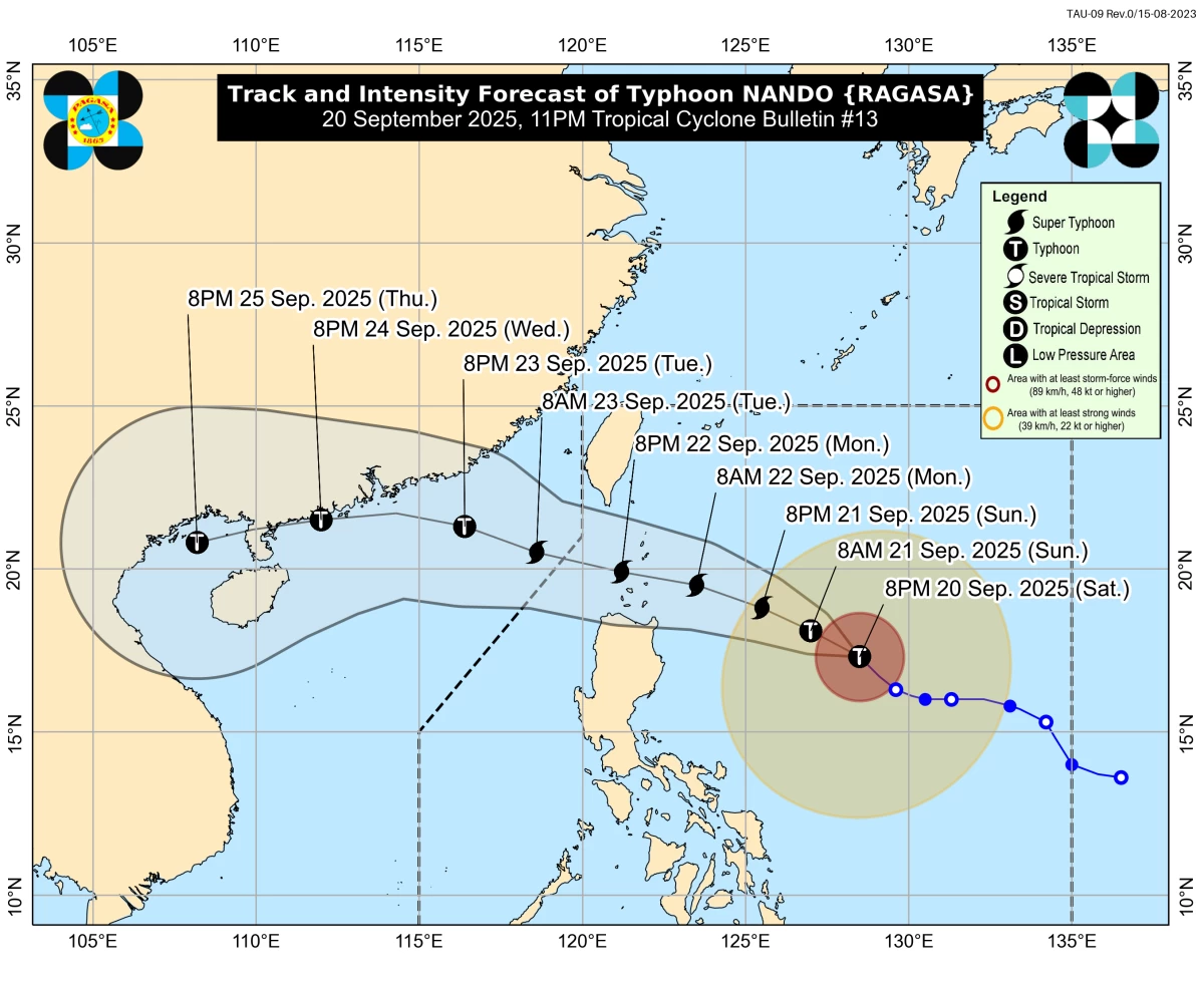
PAGASA has raised Signal No. 1 in Northern Luzon as Typhoon Nando (Ragasa) intensifies, bringing possible storm surges, heavy rains, and strong winds in the coming days. (PAGASA)
Typhoon Nando (international name: Ragasa) has further intensified as it continues to move northwestward over the Philippine Sea, the Philippine Atmospheric, Geophysical and Astronomical Services Administration (PAGASA) said on Saturday night, September 20.
At 11 p.m., PAGASA said the eye of Typhoon Nando was located 710 km east of Echague, Isabela, or 695 km east of Tuguegarao City, Cagayan.
It packs maximum sustained winds of 155 km/h near the center and gusts of up to 190 km/h, moving northwestward at 15 km/h.
PAGASA said Nando may continue to strengthen and could reach the super typhoon category by Monday, September 22, before its possible close approach to or landfall over the Batanes–Babuyan Islands area.
It is expected to exit the Philippine Area of Responsibility (PAR) by Tuesday morning, September 23.
Areas under Signal No. 1
PAGASA also placed several Luzon areas under Tropical Cyclone Wind Signal (TCWS) No. 1, where minimal to minor impacts from strong winds are possible. These include Batanes, Cagayan including Babuyan Islands, Isabela, Quirino, Apayao, Kalinga, Abra, Mountain Province, Ifugao, Benguet, Nueva Vizcaya, Ilocos Norte, Ilocos Sur, La Union, eastern Pangasinan, northern Nueva Ecija, northern and central Aurora, and northern and central Catanduanes.
The wind signals, PAGASA explained, warn the public of the general wind threat over an area due to the tropical cyclone.
“Local winds may be slightly stronger or enhanced in coastal and upland or mountainous areas exposed to winds,” PAGASA said. “Winds are less strong in areas sheltered from the prevailing wind direction,” it added.
PAGASA said minimal to minor impacts from strong winds are possible within any of the areas under Wind Signal No. 1. “The highest Wind Signal that may be hoisted throughout the passage of Nando is Wind Signal No. 5,” the weather bureau said.
Rainfall and monsoon enhancement
Typhoon Nando, along with the southwest monsoon, will bring heavy rains and strong winds across several regions: Bicol Region, Eastern Visayas, Caraga (September 20); Metro Manila, Central Luzon, CALABARZON, Bicol, MIMAROPA, Visayas, Northern Mindanao, Caraga, Davao Occidental, and Davao Oriental (September 21); and Central Luzon, Metro Manila, CALABARZON, Bicol, MIMAROPA, Visayas, Northern Mindanao, Zamboanga Peninsula, BARMM, SOCCSKSARGEN, Davao Occidental, and Davao Oriental (September 22).
Storm surge threat, sea travel risks
PAGASA warned of a high risk of life-threatening storm surges exceeding 3 meters within the next 48 hours in low-lying or coastal areas of Batanes, Cagayan (including Babuyan Islands), Ilocos Norte, and Ilocos Sur.

PAGASA
Meanwhile, a gale warning is in effect for the northern and eastern seaboards of Northern Luzon.
Very rough to very high seas reaching up to 11 meters are expected in the seaboards of Batanes, Babuyan Islands, Cagayan, and Isabela, PAGASA warned.
Mariners and fisherfolk are strongly advised to remain in port or seek safe harbor, while small boats including motorbancas are discouraged from venturing out to sea.
PAGASA urged the public, especially residents in Northern Luzon and coastal provinces, to prepare for possible flooding, landslides, and damaging winds as Nando approaches.
RELATED STORY: