


Manila Bulletin
 Philippines
National
STS Nando intensifies; may become super typhoon before hitting Batanes–Babuyan Islands — PAGASA
Philippines
National
STS Nando intensifies; may become super typhoon before hitting Batanes–Babuyan Islands — PAGASA
Philippines
National
STS Nando intensifies; may become super typhoon before hitting Batanes–Babuyan Islands — PAGASA
STS Nando intensifies; may become super typhoon before hitting Batanes–Babuyan Islands — PAGASA
Enhanced 'habagat' to bring heavy rains, strong winds in parts of Luzon, Visayas
Published Sep 20, 2025 08:58 am
|
Updated Sep 20, 2025 01:20 pm


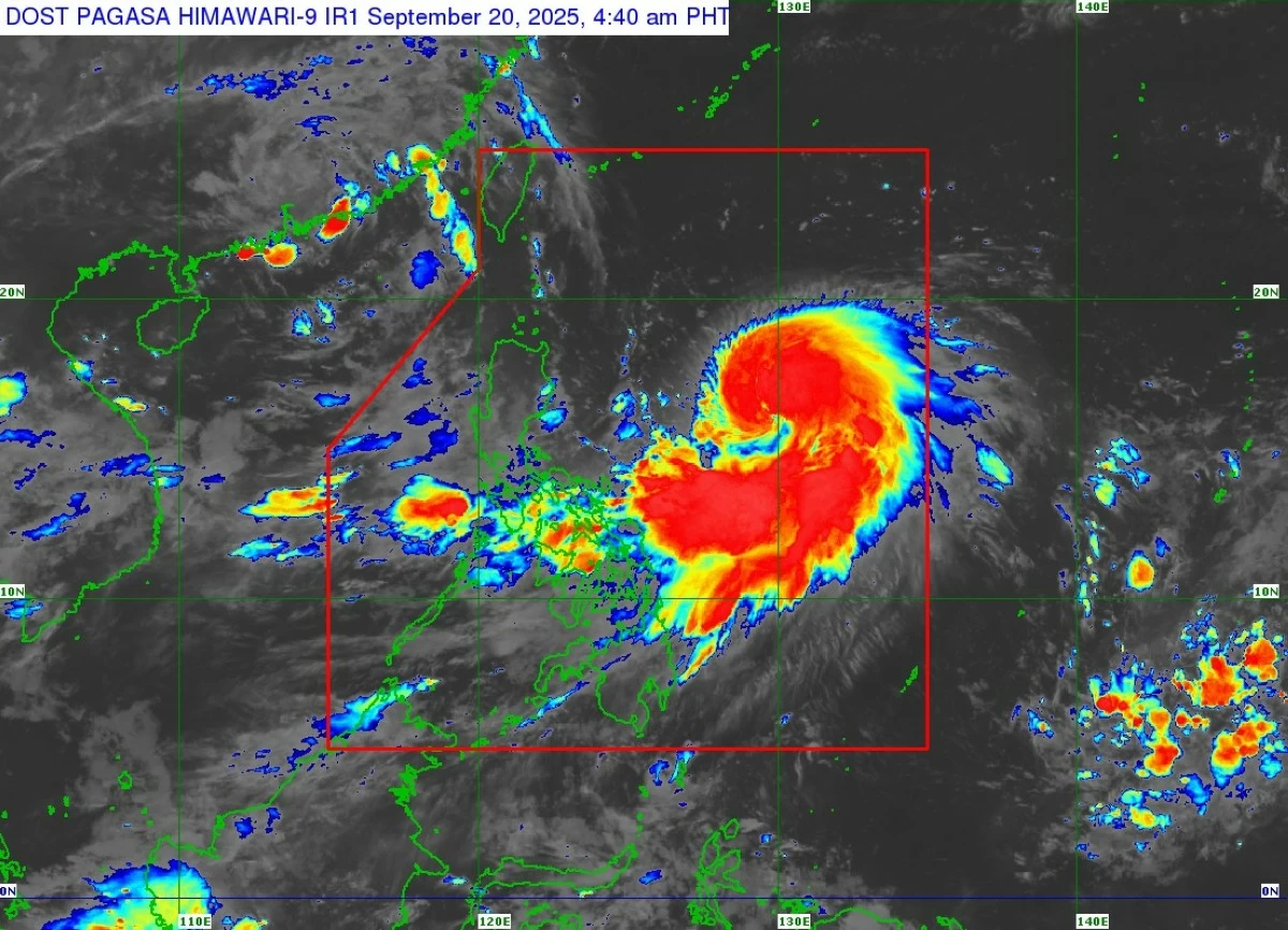
Severe Tropical Storm Nando intensifies over the Philippine Sea and may become a super typhoon before reaching the Batanes–Babuyan Islands. (PAGASA)
Severe Tropical Storm “Nando” (international name: Ragasa) continues to intensify as it moves northwest over the Philippine Sea, according to the Philippine Atmospheric, Geophysical and Astronomical Services Administration (PAGASA) on Saturday, September 20.
PAGASA weather specialist Grace Castañeda said in a press briefing that Nando is expected to approach the Batanes–Babuyan Islands by Monday afternoon or evening, September 22, and may reach super typhoon strength before making landfall.
“Patuloy pa rin na binabaybay ni Nando ang karagatan at patuloy itong nag-i-intensify. Ngayong araw, yung trough—or yung extension nito—ay magdudulot ng mga kalat-kalat na pag-ulan dito sa silangang bahagi ng Luzon at Visayas (Nando continues to traverse the ocean and is steadily intensifying. Today, its trough—or the extension of its circulation—is expected to bring scattered rain showers over the eastern parts of Luzon and Visayas),” Castañeda said.
As of 4 a.m., PAGASA reported that STS Nando’s center was located 780 km east of Casiguran, Aurora, moving northwest at 10 km/h.
STS Nando has maximum sustained winds of 100 km/h near the center, with gusts up to 125 km/h, and a central pressure of 994 hPa. Strong to storm-force winds extend up to 440 km from the center, PAGASA added.
Forecast track: STS Nando
According to PAGASA, “Nando” will continue intensifying over the Philippine Sea, potentially reaching typhoon strength within 12 hours and possibly super typhoon status by Monday, September 22, as it nears the Batanes–Babuyan Islands.
“Simula bukas, mas lalapit ito sa ating bansa at ine-expect natin na by Monday afternoon or evening, ay lalapit o magla-landfall ito dito sa Batanes–Babuyan Islands area (Starting tomorrow, the system will move closer to the country and is expected to approach or make landfall in the Batanes–Babuyan Islands by Monday afternoon or evening),” Castañeda said.
“Habang binabaybay nito ang karagatan, patuloy itong mag-i-intensify at posible itong mag-strengthen into typhoon category. Bago ito lumapit o mag-landfall sa Batanes–Babuyan Islands, maaari itong mag-intensify pa into a super typhoon (As it continues to traverse the ocean, it is steadily intensifying and may strengthen into a typhoon. Before approaching or making landfall in the Batanes–Babuyan Islands, it may further intensify into a super typhoon),” she added.
PAGASA forecasts that STS Nando may exit the Philippine Area of Responsibility (PAR) by Tuesday, September 23.
Additional hazards from southwest monsoon
Aside from “Nando’s” direct impacts, PAGASA warned that affected areas and other parts of the country should brace for heavy rains brought by the southwest monsoon.
“Ang southwest monsoon ay patuloy na umiiral dito sa western section ng Northern at Central Luzon at bahagi ng Southern Luzon at Visayas (The southwest monsoon continues to prevail over western Northern and Central Luzon, as well as parts of Southern Luzon and the Visayas),” Castañeda said.
The trough extending from Nando is expected to bring scattered rains to eastern Luzon and Visayas starting September 20.
“Dahil sa habagat, aasahan ang malalakas na pag-ulan by early next week sa western section ng Central Luzon, malaking bahagi ng Southern Luzon, at ilang bahagi ng Visayas at Mindanao (Due to the southwest monsoon, heavy rains by early next week are expected in the western section of Central Luzon, much of Southern Luzon, and parts of the Visayas and Mindanao),” she added.
Nando’s wide reach
Castañeda noted that STS Nando covers a vast area, prompting authorities to monitor not only extreme northern Luzon, where it is currently located, but also other regions in its possible path.
“Malaki yung sakop ni bagyong Nando at kailangan natin i-consider na kahit dito siya sa area ng extreme northern Luzon, ine-expect na lalapit o magla-landfall, at dahil malaki yung sakop nito, yung buong area ng Northern Luzon at ilang bahagi ng Central Luzon ay makakaranas ng malalakas na hangin at malalakas na ulan (Typhoon Nando has a wide coverage. Even though it is currently in extreme northern Luzon and is expected to approach or make landfall there, its broad reach means the entire Northern Luzon region and parts of Central Luzon will experience strong winds and heavy rainfall),” she added.
The direct impact of “Nando” is expected across northern Luzon and parts of Central Luzon. The southwest monsoon, enhanced by "Nando," may also trigger flooding and landslides in western Central Luzon, much of Southern Luzon, and parts of Visayas and Mindanao according to PAGASA.
“Dobleng ingat at paghahanda para sa ating mga kababayan (Extra caution and preparedness are urged for our fellow citizens),” Castañeda said.
Impact on land and coastal areas
While no wind signal has been hoisted yet, PAGASA said "Nando" is enhancing the southwest monsoon, bringing heavy rainfall and gusty winds across northern and central Luzon, parts of Visayas, and Mindanao.
Forecasts by date and region:
September 20 - Bicol Region, Eastern Visayas, Caraga – heavy rainfall and gusty winds
September 21 - Central Luzon, Metro Manila, CALABARZON, MIMAROPA, Visayas, Northern Mindanao – heavy rainfall
September 22 - Central Luzon, Metro Manila, CALABARZON, Bicol Region, MIMAROPA, Visayas, Northern Mindanao, Zamboanga Peninsula, BARMM, SOCCSKSARGEN, parts of Davao – gale-force gusts
PAGASA said a storm surge warning may also be raised over Northern Luzon’s coastal waters.
Mariners were also advised to take precautions due to moderate to rough seas, with waves reaching up to 3.0 meters along the eastern seaboards of Cagayan, Isabela, and Catanduanes, and up to 2.5 meters in other exposed areas.
RELATED STORY: