ADVERTISEMENT

'Nando' rapidly intensifies into typhoon — PAGASA

May reach super typhoon category before landfall; storm surge warning issued for N. Luzon areas

Published Sep 20, 2025 12:06 pm
Severe Tropical Storm Nando has intensified into a typhoon and may reach super typhoon strength before hitting Batanes-Babuyan Islands. (PAGASA)
The Philippine Atmospheric, Geophysical and Astronomical Services Administration (PAGASA) on Saturday, September 20, reported that Severe Tropical Storm Nando (international name: Ragasa) has rapidly intensified and is now a typhoon.
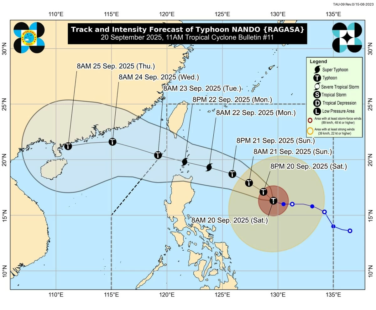
In its 11 a.m. tropical cyclone bulletin, PAGASA said “Nando” has strengthened over the Philippine Sea and may reach super typhoon strength before approaching or making landfall in the Batanes-Babuyan Islands by Monday, September 22.
As of 10 a.m., PAGASA located the center of typhoon Nando’s eye approximately 775 kilometers east of Casiguran, Aurora, moving west-northwest at 10 km/h. The typhoon currently packs maximum sustained winds of 120 km/h near the center, with gusts reaching up to 150 km/h, and a central pressure of 985 hPa. Typhoon-force winds may extend up to 500 km from the center.
Heavy rainfall, strong winds expected
PAGASA warned that “Nando” will enhance the southwest monsoon (habagat), bringing strong to gale-force winds and heavy rainfall over Luzon, Visayas, and parts of Mindanao over the next few days.
“‘Nando will enhance the southwest monsoon as it approaches the landmass,” PAGASA said. “Wind Signal No. 1 will be hoisted over Northern Luzon and the eastern portion of Central Luzon this afternoon, and the highest wind signal that may be raised during its passage is Wind Signal No. 5.”
Residents are urged to secure property, take necessary precautions, and follow updates from local authorities.
Storm surge risk, coastal hazards
Sea conditions are expected to be moderate to rough, with waves reaching up to 3 meters in Batanes, Cagayan, Isabela, and Catanduanes, and up to 2.5 meters along other eastern seaboards, including Babuyan Islands, Polillo Islands, Albay, and Sorsogon.
Mariners are advised to exercise extreme caution or avoid travel at sea, PAGASA said.
PAGASA also issued a Storm Surge Warning, highlighting the high risk of life-threatening storm surges of up to 3 meters in low-lying coastal areas of Batanes, Cagayan, Ilocos Norte, and Ilocos Sur over the next 96 hours.
Track and intensity outlook
PAGASA said typhoon Nando is forecast to move northwestward over the next 12 hours, then turn west-northwest toward extreme Northern Luzon. It may pass close to or make landfall over Batanes or the Babuyan Islands by Monday afternoon or evening.
“Nando” is also expected to exit the Philippine Area of Responsibility (PAR) by Tuesday morning, September 23, potentially maintaining super typhoon strength.
PAGASA advised public and disaster management offices to take necessary precautions to protect life and property, especially in areas highly susceptible to flooding, strong winds, and storm surges.
RELATED STORY: 
https://mb.com.ph/2025/09/19/tropical-cyclone-nando-tracker

Related Tags

Typhoon Nando NandoPH Nando PAGASA update PAGASA PAGASA weather update habagat storm surge warning Philippines
ADVERTISEMENT
.most-popular .layout-ratio{ padding-bottom: 79.13%; } @media (min-width: 768px) and (max-width: 1024px) { .widget-title { font-size: 15px !important; } }

{{ articles_filter_1561_widget.title }}

.most-popular .layout-ratio{ padding-bottom: 79.13%; } @media (min-width: 768px) and (max-width: 1024px) { .widget-title { font-size: 15px !important; } }

{{ articles_filter_1562_widget.title }}

.most-popular .layout-ratio{ padding-bottom: 79.13%; } @media (min-width: 768px) and (max-width: 1024px) { .widget-title { font-size: 15px !important; } }

{{ articles_filter_1563_widget.title }}

{{ articles_filter_1564_widget.title }}

.mb-article-details { position: relative; } .mb-article-details .article-body-preview, .mb-article-details .article-body-summary{ font-size: 17px; line-height: 30px; font-family: "Libre Caslon Text", serif; color: #000; } .mb-article-details .article-body-preview iframe , .mb-article-details .article-body-summary iframe{ width: 100%; margin: auto; } .read-more-background { background: linear-gradient(180deg, color(display-p3 1.000 1.000 1.000 / 0) 13.75%, color(display-p3 1.000 1.000 1.000 / 0.8) 30.79%, color(display-p3 1.000 1.000 1.000) 72.5%); position: absolute; height: 200px; width: 100%; bottom: 0; display: flex; justify-content: center; align-items: center; padding: 0; } .read-more-background a{ color: #000; } .read-more-btn { padding: 17px 45px; font-family: Inter; font-weight: 700; font-size: 18px; line-height: 16px; text-align: center; vertical-align: middle; border: 1px solid black; background-color: white; } .hidden { display: none; }
function initializeAllSwipers() { // Get all hidden inputs with cms_article_id document.querySelectorAll('[id^="cms_article_id_"]').forEach(function (input) { const cmsArticleId = input.value; const articleSelector = '#article-' + cmsArticleId + ' .body_images'; const swiperElement = document.querySelector(articleSelector); if (swiperElement && !swiperElement.classList.contains('swiper-initialized')) { new Swiper(articleSelector, { loop: true, pagination: false, navigation: { nextEl: '#article-' + cmsArticleId + ' .swiper-button-next', prevEl: '#article-' + cmsArticleId + ' .swiper-button-prev', }, }); } }); } setTimeout(initializeAllSwipers, 3000); const intersectionObserver = new IntersectionObserver( (entries) => { entries.forEach((entry) => { if (entry.isIntersecting) { const newUrl = entry.target.getAttribute("data-url"); if (newUrl) { history.pushState(null, null, newUrl); let article = entry.target; // Extract metadata const author = article.querySelector('.author-section').textContent.replace('By', '').trim(); const section = article.querySelector('.section-info ').textContent.replace(' ', ' '); const title = article.querySelector('.article-title h1').textContent; // Parse URL for Chartbeat path format const parsedUrl = new URL(newUrl, window.location.origin); const cleanUrl = parsedUrl.host + parsedUrl.pathname; // Update Chartbeat configuration if (typeof window._sf_async_config !== 'undefined') { window._sf_async_config.path = cleanUrl; window._sf_async_config.sections = section; window._sf_async_config.authors = author; } // Track virtual page view with Chartbeat if (typeof pSUPERFLY !== 'undefined' && typeof pSUPERFLY.virtualPage === 'function') { try { pSUPERFLY.virtualPage({ path: cleanUrl, title: title, sections: section, authors: author }); } catch (error) { console.error('ping error', error); } } // Optional: Update document title if (title && title !== document.title) { document.title = title; } } } }); }, { threshold: 0.1 } ); function showArticleBody(button) { const article = button.closest("article"); const summary = article.querySelector(".article-body-summary"); const body = article.querySelector(".article-body-preview"); const readMoreSection = article.querySelector(".read-more-background"); // Hide summary and read-more section summary.style.display = "none"; readMoreSection.style.display = "none"; // Show the full article body body.classList.remove("hidden"); } document.addEventListener("DOMContentLoaded", () => { let loadCount = 0; // Track how many times articles are loaded const offset = [1, 2, 3, 4, 5, 6, 7, 8, 9, 10]; // Offset values const currentUrl = window.location.pathname.substring(1); let isLoading = false; // Prevent multiple calls if (!currentUrl) { console.log("Current URL is invalid."); return; } const sentinel = document.getElementById("load-more-sentinel"); if (!sentinel) { console.log("Sentinel element not found."); return; } function isSentinelVisible() { const rect = sentinel.getBoundingClientRect(); return ( rect.top < window.innerHeight && rect.bottom >= 0 ); } function onScroll() { if (isLoading) return; if (isSentinelVisible()) { if (loadCount >= offset.length) { console.log("Maximum load attempts reached."); window.removeEventListener("scroll", onScroll); return; } isLoading = true; const currentOffset = offset[loadCount]; window.loadMoreItems().then(() => { let article = document.querySelector('#widget_1690 > div:nth-last-of-type(2) article'); intersectionObserver.observe(article) loadCount++; }).catch(error => { console.error("Error loading more items:", error); }).finally(() => { isLoading = false; }); } } window.addEventListener("scroll", onScroll); });

Sign up by email to receive news.