ADVERTISEMENT

14 areas under Signal No. 1 as 'Nando' further intensifies over Philippine Sea --- PAGASA

Published Sep 20, 2025 05:45 pm
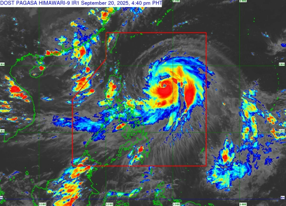
PAGASA raises Signal No. 1 in 14 areas as Typhoon Nando intensifies over the Philippine Sea, bringing strong winds, heavy rains, and coastal hazards. (PAGASA)
Typhoon Nando (international name: Ragasa) further intensified while moving northwestward over the Philippine Sea, the Philippine Atmospheric, Geophysical and Astronomical Services Administration (PAGASA) said on Saturday, September 20.
In its 5 p.m. bulletin, the state weather bureau said the center of Typhoon Nando was estimated at 770 km east of Echague, Isabela, with maximum sustained winds of 140 km/h, gusts of up to 170 km/h, and a central pressure of 970 hPa as of 4 p.m.
PAGASA said “Nando” is moving northwestward at 10 km/h.
Threat of strong winds
PAGASA has hoisted Signal No. 1 in several areas due to the threat of strong winds (39–61 km/h) within 36 hours.
The areas under Tropical Cyclone Wind Signal (TCWS) No. 1 are:
1.  Batanes
2.  Cagayan, including the Babuyan Islands
3.  Isabela
4. Quirino
5.  Northeastern Nueva Vizcaya (Kasibu, Quezon, Diadi, Bagabag, Villaverde, Solano, Ambaguio, Bayombong, Bambang, Dupax del Norte)
6.  Apayao
7.  Kalinga
8.  Abra
9.  Mountain Province
10.  Ifugao
11.  Ilocos Norte
12.  Northern Ilocos Sur (including Vigan City and nearby towns)
13.  Northern and central Aurora (Dilasag, Casiguran, Dinalungan, Dipaculao, Baler)
14.  Northern and central Catanduanes (Pandan, Caramoran, Bagamanoc, Panganiban, Viga, Gigmoto, San Miguel, Baras)
PAGASA warned of minimal to minor impacts on life and property in these areas. However, stronger winds may be felt in coastal and upland communities directly exposed to the cyclone.
“Minimal to minor impacts from strong winds are possible within any of the areas under Wind Signal No. 1,” PAGASA said. “The highest wind signal that may be hoisted during the passage of Nando is Signal No. 5,” the weather bureau added.
Forecast track and intensity
PAGASA said Typhoon Nando is expected to move northwestward in the next 12 hours before turning west-northwest.
The storm may pass close to or make landfall over Batanes or the Babuyan Islands between Monday afternoon and evening, September 22.
It is forecast to exit the Philippine Area of Responsibility (PAR) by Tuesday morning, September 23.
PAGASA said “Nando” may reach super typhoon category by Monday while still over the Philippine Sea.
Heavy rainfall, wind, and coastal hazards
Heavy rains and gusty winds started affecting the Bicol Region, Eastern Visayas, and Caraga on Saturday, September 20.
By September 21, PAGASA said strong monsoon rains and gusts are expected over Metro Manila, Central Luzon, CALABARZON, Bicol, MIMAROPA, Visayas, Northern Mindanao, Caraga, and parts of Davao.
Widespread rains and strong winds may extend to the Zamboanga Peninsula, BARMM, SOCCSKSARGEN, and Davao Region on September 22.
PAGASA said a gale warning remains in effect over the northern and eastern seaboards of Northern Luzon. Seas may reach:
- up to 4.5 meters along the seaboards of Batanes, the Babuyan Islands, Cagayan, and Isabela — making sea travel risky for all vessels;
- up to 3.0 meters over the northeastern coast of Aurora; and
- up to 2.5 meters over the eastern seaboards of the Polillo Islands, Albay, Sorsogon, the Camarines provinces, and Northern Samar.
Mariners were strongly advised against sea travel in areas under gale warnings.
A life-threatening storm surge exceeding 3 meters is possible in low-lying coastal areas of Batanes, Cagayan (including the Babuyan Islands), Ilocos Norte, and Ilocos Sur within 72 hours, PAGASA warned.
The weather bureau also urged residents in affected areas to prepare for possible evacuation, secure property, and follow local government advisories.
READ: 
https://mb.com.ph/2025/09/19/tropical-cyclone-nando-tracker

Related Tags

Typhoon Nando NandoPH Signal No. 1 PAGASA PAGASA weather update habagat storm surge warning Philippines
ADVERTISEMENT
.most-popular .layout-ratio{ padding-bottom: 79.13%; } @media (min-width: 768px) and (max-width: 1024px) { .widget-title { font-size: 15px !important; } }

{{ articles_filter_1561_widget.title }}

.most-popular .layout-ratio{ padding-bottom: 79.13%; } @media (min-width: 768px) and (max-width: 1024px) { .widget-title { font-size: 15px !important; } }

{{ articles_filter_1562_widget.title }}

.most-popular .layout-ratio{ padding-bottom: 79.13%; } @media (min-width: 768px) and (max-width: 1024px) { .widget-title { font-size: 15px !important; } }

{{ articles_filter_1563_widget.title }}

{{ articles_filter_1564_widget.title }}

.mb-article-details { position: relative; } .mb-article-details .article-body-preview, .mb-article-details .article-body-summary{ font-size: 17px; line-height: 30px; font-family: "Libre Caslon Text", serif; color: #000; } .mb-article-details .article-body-preview iframe , .mb-article-details .article-body-summary iframe{ width: 100%; margin: auto; } .read-more-background { background: linear-gradient(180deg, color(display-p3 1.000 1.000 1.000 / 0) 13.75%, color(display-p3 1.000 1.000 1.000 / 0.8) 30.79%, color(display-p3 1.000 1.000 1.000) 72.5%); position: absolute; height: 200px; width: 100%; bottom: 0; display: flex; justify-content: center; align-items: center; padding: 0; } .read-more-background a{ color: #000; } .read-more-btn { padding: 17px 45px; font-family: Inter; font-weight: 700; font-size: 18px; line-height: 16px; text-align: center; vertical-align: middle; border: 1px solid black; background-color: white; } .hidden { display: none; }
function initializeAllSwipers() { // Get all hidden inputs with cms_article_id document.querySelectorAll('[id^="cms_article_id_"]').forEach(function (input) { const cmsArticleId = input.value; const articleSelector = '#article-' + cmsArticleId + ' .body_images'; const swiperElement = document.querySelector(articleSelector); if (swiperElement && !swiperElement.classList.contains('swiper-initialized')) { new Swiper(articleSelector, { loop: true, pagination: false, navigation: { nextEl: '#article-' + cmsArticleId + ' .swiper-button-next', prevEl: '#article-' + cmsArticleId + ' .swiper-button-prev', }, }); } }); } setTimeout(initializeAllSwipers, 3000); const intersectionObserver = new IntersectionObserver( (entries) => { entries.forEach((entry) => { if (entry.isIntersecting) { const newUrl = entry.target.getAttribute("data-url"); if (newUrl) { history.pushState(null, null, newUrl); let article = entry.target; // Extract metadata const author = article.querySelector('.author-section').textContent.replace('By', '').trim(); const section = article.querySelector('.section-info ').textContent.replace(' ', ' '); const title = article.querySelector('.article-title h1').textContent; // Parse URL for Chartbeat path format const parsedUrl = new URL(newUrl, window.location.origin); const cleanUrl = parsedUrl.host + parsedUrl.pathname; // Update Chartbeat configuration if (typeof window._sf_async_config !== 'undefined') { window._sf_async_config.path = cleanUrl; window._sf_async_config.sections = section; window._sf_async_config.authors = author; } // Track virtual page view with Chartbeat if (typeof pSUPERFLY !== 'undefined' && typeof pSUPERFLY.virtualPage === 'function') { try { pSUPERFLY.virtualPage({ path: cleanUrl, title: title, sections: section, authors: author }); } catch (error) { console.error('ping error', error); } } // Optional: Update document title if (title && title !== document.title) { document.title = title; } } } }); }, { threshold: 0.1 } ); function showArticleBody(button) { const article = button.closest("article"); const summary = article.querySelector(".article-body-summary"); const body = article.querySelector(".article-body-preview"); const readMoreSection = article.querySelector(".read-more-background"); // Hide summary and read-more section summary.style.display = "none"; readMoreSection.style.display = "none"; // Show the full article body body.classList.remove("hidden"); } document.addEventListener("DOMContentLoaded", () => { let loadCount = 0; // Track how many times articles are loaded const offset = [1, 2, 3, 4, 5, 6, 7, 8, 9, 10]; // Offset values const currentUrl = window.location.pathname.substring(1); let isLoading = false; // Prevent multiple calls if (!currentUrl) { console.log("Current URL is invalid."); return; } const sentinel = document.getElementById("load-more-sentinel"); if (!sentinel) { console.log("Sentinel element not found."); return; } function isSentinelVisible() { const rect = sentinel.getBoundingClientRect(); return ( rect.top < window.innerHeight && rect.bottom >= 0 ); } function onScroll() { if (isLoading) return; if (isSentinelVisible()) { if (loadCount >= offset.length) { console.log("Maximum load attempts reached."); window.removeEventListener("scroll", onScroll); return; } isLoading = true; const currentOffset = offset[loadCount]; window.loadMoreItems().then(() => { let article = document.querySelector('#widget_1690 > div:nth-last-of-type(2) article'); intersectionObserver.observe(article) loadCount++; }).catch(error => { console.error("Error loading more items:", error); }).finally(() => { isLoading = false; }); } } window.addEventListener("scroll", onScroll); });

Sign up by email to receive news.