


Manila Bulletin
 Philippines
National
Super typhoon threat looms: 'Nando,' 'habagat' to bring heavy rains, strong winds starting weekend — PAGASA
Philippines
National
Super typhoon threat looms: 'Nando,' 'habagat' to bring heavy rains, strong winds starting weekend — PAGASA
Philippines
National
Super typhoon threat looms: 'Nando,' 'habagat' to bring heavy rains, strong winds starting weekend — PAGASA
Super typhoon threat looms: 'Nando,' 'habagat' to bring heavy rains, strong winds starting weekend — PAGASA
Published Sep 19, 2025 06:27 pm


Tropical Storm Nando (international name: Ragasa) is expected to enhance the ‘habagat,’ bringing heavy rains, severe winds, and storm surge risks. ((PAGASA)
Tropical Storm “Nando” (international name: Ragasa) continues to intensify over the Philippine Sea, with the state weather bureau warning on Friday, September 19, that it could trigger Signal No. 5 in Northern Luzon and enhance the southwest monsoon (habagat) to bring heavy rains and strong winds starting this weekend.
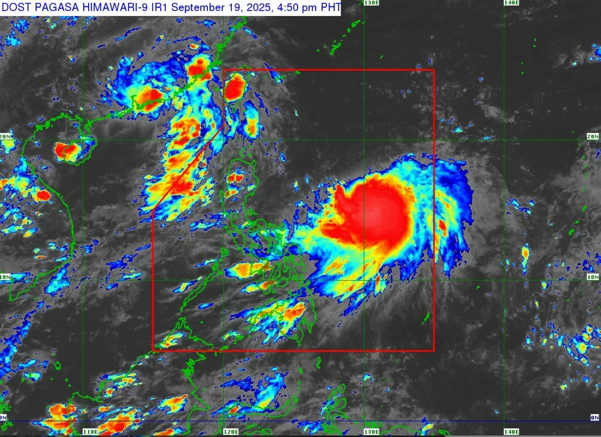
In its 5 p.m. bulletin, the Philippine Atmospheric, Geophysical and Astronomical Services Administration (PAGASA said “Nando” slightly intensified as it tracked west-northwestward over the Philippine Sea.
PAGASA located TS Nando’s center 905 kilometers east of Central Luzon, with maximum sustained winds of 85 km/h near the center and gusts reaching 105 km/h. It was moving west-northwest at 10 km/h.
Habagat, ‘Nando’ to trigger rains, severe winds
PAGASA said the combined effects of Nando and the enhanced southwest monsoon will begin bringing heavy rains and strong winds by Sunday, September 21.
The agency warned that Tropical Cyclone Wind Signal (TCWS) No. 1 may be raised over parts of Northern Luzon by Saturday morning, September 20.
The highest possible alert level that could be raised during the storm’s passage is Signal No. 5.
Areas likely to experience strong to gale-force winds include the Bicol Region, Eastern Visayas, and Caraga (September 20), and Calabarzon, Bicol Region, Visayas, Northern Mindanao, and Caraga (September 21).
Coastal and sea hazards
PAGASA said “Nando” is not expected to affect sea conditions in the next 24 hours.
However, moderate to rough seas will prevail over most Luzon coasts beginning Saturday evening.
As the storm approaches Extreme Northern Luzon, wave heights may reach up to 14 meters, and storm surge warnings may be raised in Northern Luzon’s coastal areas, PAGASA warned.
Forecast track
PAGASA said “Nando” is expected to move generally northwest until Saturday before turning west-northwest toward Extreme Northern Luzon.
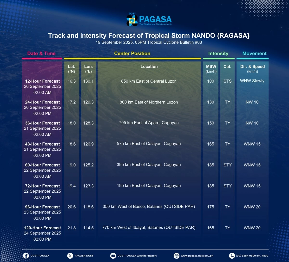
PAGASA warns that Tropical Storm Nando may strengthen into a super typhoon before nearing the Babuyan Islands on September 22 to 23, 2025. (PAGASA)
On its track, the storm may pass close to or make landfall over the Babuyan Islands between Monday afternoon, September 22, and early Tuesday morning, September 23.
“Nando will continue to intensify while over the Philippine Sea,” PAGASA said. “It may reach typhoon category tomorrow and super typhoon by Monday before its close approach to the Babuyan Islands,” the state weather bureau added.
Based on its latest forecast, Nando will be 850 km east of Central Luzon (September 20, 2 a.m.); 800 km east of Northern Luzon (September 20, 2 p.m.); 705 km east of Aparri, Cagayan (September 21, 2 a.m.); 575 km east of Calayan, Cagayan (September 21, 2 p.m.); 395 km east of Calayan, Cagayan (September 22, 2 a.m.); and 195 km east of Calayan, Cagayan (September 22, 2 p.m.).
“Nando” is forecast to be 350 km west of Basco, Batanes, on September 23, 2 p.m., before leaving the Philippine Area of Responsibility (PAR).
PAGASA urged residents of Northern Luzon and the eastern seaboards to prepare for possible severe winds, floods, and storm surges, and to closely monitor updates.
“Considering these developments, the public and disaster risk reduction and management offices concerned are advised to take all necessary measures to protect life and property,” PAGASA said.
READ: