ADVERTISEMENT

PAGASA: 'Nando' intensifies into a severe tropical storm

STS Nando may reach super typhoon category before hitting Batanes-Babuyan Islands

Published Sep 19, 2025 11:32 pm
HEAVY RAINS AND STRONG WINDS EXPECTED. Tropical Storm Nando intensifies into a Severe Tropical Storm on September 19, 2025 and may become a super typhoon before hitting Batanes-Babuyan according to PAGASA.
Tropical Storm Nando (international name: Ragasa) has intensified into a Severe Tropical Storm over the Philippine Sea and may reach super typhoon status before its expected close approach or possible landfall over the Batanes-Babuyan Islands early next week.
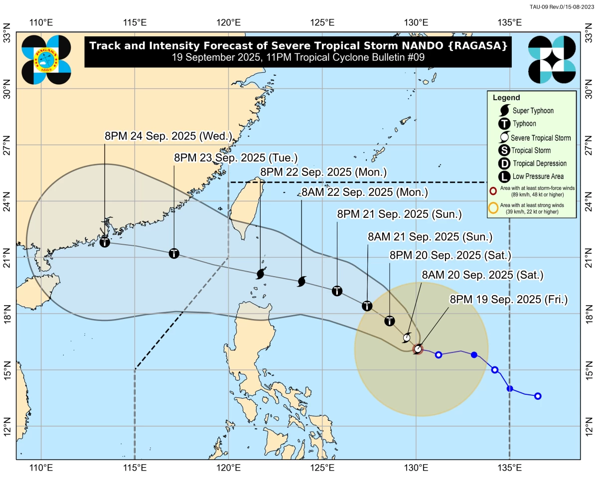
In its 11 p.m. bulletin on Friday, September 19, the Philippine Atmospheric, Geophysical, and Astronomical Services Administration (PAGASA) said STS Nando is expected to strengthen into a typhoon by Saturday and may reach super typhoon intensity before nearing the Batanes and Babuyan Islands on Monday, September 22.
PAGASA said the center of Nando was located 840 km east of Central Luzon, moving westward at 10 km/h, with maximum sustained winds of 95 km/h and gusts up to 115 km/h as of 11 p.m.
According to PAGASA’s forecast, “Nando” will be 790 km east of Casiguran, Aurora at 8 a.m. on September 20; 455 km east of Calayan, Cagayan at 8 p.m. on September 21; and over the coastal waters of Sabtang, Batanes at around 8 p.m. on September 22.
PAGASA said STS Nando is expected to exit the Philippine Area of Responsibility (PAR) by Tuesday morning, September 23.
Brace for heavy rains and strong winds
PAGASA warned that “Nando,” in combination with the southwest monsoon (habagat), may trigger heavy rainfall starting Sunday, September 21.
“Nando may enhance the southwest monsoon as it approaches the landmass,” PAGASA said.
The state weather bureau also announced the hoisting of Tropical Cyclone Wind Signal (TCWS) No. 1 over Northern Luzon on Saturday morning, with the potential to escalate to Signal No. 5 at the storm’s peak.
“Wind Signal No. 1 will be hoisted over Northern Luzon tomorrow (September 20) morning, and the highest wind signal that may be raised during its passage is Wind Signal No. 5,” it added.
PAGASA advised residents in coastal and upland areas to remain vigilant as strong to gale-force gusts are expected in the following areas: Bicol Region, Eastern Visayas, Caraga (September 20); Zambales, Bataan, CALABARZON, Bicol, MIMAROPA, Visayas, Northern Mindanao, Caraga (September 21); and Zambales, Bataan, CALABARZON, Bicol, MIMAROPA, Visayas, Northern Mindanao, Caraga, Davao Occidental (September 22).
Storm surge, sea conditions, and coastal hazards
PAGASA urged communities in Northern and Central Luzon, Visayas, and Northern Mindanao to monitor weather updates closely and prepare for potential flooding, strong winds, and coastal hazards.
“A storm surge warning may also be issued over Northern Luzon coastal waters tomorrow,” PAGASA said.
The weather bureau added that moderate seas of up to 2.5 meters are forecast along the eastern seaboards of Batanes, Cagayan (including Babuyan Islands), Isabela, and Catanduanes.
PAGASA also cautioned mariners of small vessels to take precautionary measures or avoid venturing out to sea.
RELATED STORY: 
https://mb.com.ph/2025/09/19/tropical-cyclone-nando-tracker

Related Tags

Tropical Storm Nando Nando NandoPH Severe Tropical Storm Nando PAGASA weather update
ADVERTISEMENT
.most-popular .layout-ratio{ padding-bottom: 79.13%; } @media (min-width: 768px) and (max-width: 1024px) { .widget-title { font-size: 15px !important; } }

{{ articles_filter_1561_widget.title }}

.most-popular .layout-ratio{ padding-bottom: 79.13%; } @media (min-width: 768px) and (max-width: 1024px) { .widget-title { font-size: 15px !important; } }

{{ articles_filter_1562_widget.title }}

.most-popular .layout-ratio{ padding-bottom: 79.13%; } @media (min-width: 768px) and (max-width: 1024px) { .widget-title { font-size: 15px !important; } }

{{ articles_filter_1563_widget.title }}

{{ articles_filter_1564_widget.title }}

.mb-article-details { position: relative; } .mb-article-details .article-body-preview, .mb-article-details .article-body-summary{ font-size: 17px; line-height: 30px; font-family: "Libre Caslon Text", serif; color: #000; } .mb-article-details .article-body-preview iframe , .mb-article-details .article-body-summary iframe{ width: 100%; margin: auto; } .read-more-background { background: linear-gradient(180deg, color(display-p3 1.000 1.000 1.000 / 0) 13.75%, color(display-p3 1.000 1.000 1.000 / 0.8) 30.79%, color(display-p3 1.000 1.000 1.000) 72.5%); position: absolute; height: 200px; width: 100%; bottom: 0; display: flex; justify-content: center; align-items: center; padding: 0; } .read-more-background a{ color: #000; } .read-more-btn { padding: 17px 45px; font-family: Inter; font-weight: 700; font-size: 18px; line-height: 16px; text-align: center; vertical-align: middle; border: 1px solid black; background-color: white; } .hidden { display: none; }
function initializeAllSwipers() { // Get all hidden inputs with cms_article_id document.querySelectorAll('[id^="cms_article_id_"]').forEach(function (input) { const cmsArticleId = input.value; const articleSelector = '#article-' + cmsArticleId + ' .body_images'; const swiperElement = document.querySelector(articleSelector); if (swiperElement && !swiperElement.classList.contains('swiper-initialized')) { new Swiper(articleSelector, { loop: true, pagination: false, navigation: { nextEl: '#article-' + cmsArticleId + ' .swiper-button-next', prevEl: '#article-' + cmsArticleId + ' .swiper-button-prev', }, }); } }); } setTimeout(initializeAllSwipers, 3000); const intersectionObserver = new IntersectionObserver( (entries) => { entries.forEach((entry) => { if (entry.isIntersecting) { const newUrl = entry.target.getAttribute("data-url"); if (newUrl) { history.pushState(null, null, newUrl); let article = entry.target; // Extract metadata const author = article.querySelector('.author-section').textContent.replace('By', '').trim(); const section = article.querySelector('.section-info ').textContent.replace(' ', ' '); const title = article.querySelector('.article-title h1').textContent; // Parse URL for Chartbeat path format const parsedUrl = new URL(newUrl, window.location.origin); const cleanUrl = parsedUrl.host + parsedUrl.pathname; // Update Chartbeat configuration if (typeof window._sf_async_config !== 'undefined') { window._sf_async_config.path = cleanUrl; window._sf_async_config.sections = section; window._sf_async_config.authors = author; } // Track virtual page view with Chartbeat if (typeof pSUPERFLY !== 'undefined' && typeof pSUPERFLY.virtualPage === 'function') { try { pSUPERFLY.virtualPage({ path: cleanUrl, title: title, sections: section, authors: author }); } catch (error) { console.error('ping error', error); } } // Optional: Update document title if (title && title !== document.title) { document.title = title; } } } }); }, { threshold: 0.1 } ); function showArticleBody(button) { const article = button.closest("article"); const summary = article.querySelector(".article-body-summary"); const body = article.querySelector(".article-body-preview"); const readMoreSection = article.querySelector(".read-more-background"); // Hide summary and read-more section summary.style.display = "none"; readMoreSection.style.display = "none"; // Show the full article body body.classList.remove("hidden"); } document.addEventListener("DOMContentLoaded", () => { let loadCount = 0; // Track how many times articles are loaded const offset = [1, 2, 3, 4, 5, 6, 7, 8, 9, 10]; // Offset values const currentUrl = window.location.pathname.substring(1); let isLoading = false; // Prevent multiple calls if (!currentUrl) { console.log("Current URL is invalid."); return; } const sentinel = document.getElementById("load-more-sentinel"); if (!sentinel) { console.log("Sentinel element not found."); return; } function isSentinelVisible() { const rect = sentinel.getBoundingClientRect(); return ( rect.top < window.innerHeight && rect.bottom >= 0 ); } function onScroll() { if (isLoading) return; if (isSentinelVisible()) { if (loadCount >= offset.length) { console.log("Maximum load attempts reached."); window.removeEventListener("scroll", onScroll); return; } isLoading = true; const currentOffset = offset[loadCount]; window.loadMoreItems().then(() => { let article = document.querySelector('#widget_1690 > div:nth-last-of-type(2) article'); intersectionObserver.observe(article) loadCount++; }).catch(error => { console.error("Error loading more items:", error); }).finally(() => { isLoading = false; }); } } window.addEventListener("scroll", onScroll); });

Sign up by email to receive news.