ADVERTISEMENT

'Nando' may make landfall as a super typhoon — PAGASA

Signal No. 5 could be raised in extreme Northern Luzon, other areas; 'habagat' to persist

Published Sep 19, 2025 02:51 pm
Tropical Storm Nando (international name: Ragasa) may intensify into a super typhoon before landfall, PAGASA warns. (PAGASA)
The Philippine Atmospheric, Geophysical and Astronomical Services Administration (PAGASA) is not ruling out the possibility of Tropical Storm “Nando” (international name: Ragasa) intensifying into a super typhoon before it makes landfall in the country.
Department of Science and Technology – PAGASA – Philippine Atmospheric, Geophysical and Astronomical Services Administration (DOST-PAGASA) Assistant Weather Services Chief Chris Perez, in a press briefing on Friday, September 19, called for vigilance and urged early preparations for TS Nando.
Perez said “Nando” is still not expected to have a direct effect on any part of the country. However, rains are expected in several areas due to the southwest monsoon (habagat).
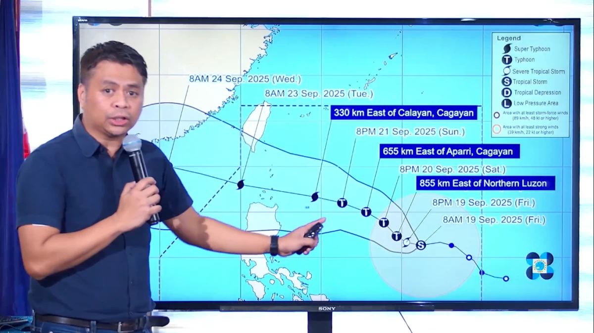
Forecast track
Perez said “Nando” is forecast to become a typhoon by Saturday morning, September 20, and may intensify further into a super typhoon by Monday, September 22, as it approaches Extreme Northern Luzon.
Based on the forecast track, Perez said “Nando” could:
- make landfall over the Babuyan Islands between late Monday and early Tuesday (Sept. 22–23), or
- pass through the waters surrounding the island group before exiting the Philippine Area of Responsibility (PAR) by Tuesday afternoon.
If "Nando" reaches super typhoon strength, Perez said Tropical Cyclone Wind Signal (TCWS) No. 5 may be raised in parts of Northern Luzon.
DOST-PAGASA Assistant Weather Services Chief Chris Perez said in a press briefing on September 19, 2025, that Signal No. 5 could be raised in extreme Northern Luzon and nearby areas if Tropical Storm Nando intensifies into a super typhoon. (Screenshot: PAGASA/ Facebook)
“Sa ngayon, malayo pa si Nando sa ating kalupaan at wala pang direktang epekto sa bahagi ng bansa (As of now, Nando is still far from our land and has no direct impact on any part of the country),” Perez said.
Perez said PAGASA is closely tracking TS Nando’s movements in the coming days. “Simula sa tropical storm category, posibleng by Saturday morning or bukas, ay umabot na ito sa typhoon category (Starting from the tropical storm category, it’s possible that by Saturday morning or tomorrow, it may intensify into a typhoon),” he explained.
“Sa darating na Lunes, possible pang umabot ito sa super typhoon category bago nga tuluyang tumama sa Extreme Northern Luzon area (By Monday, it’s still possible for it to reach the super typhoon category before finally making landfall in the Extreme Northern Luzon area),” he added.
Based on the latest forecast track, Perez said there is a possibility that “Nando” will either make landfall on any of the Babuyan Islands or cross the waters between these islands on Monday night, September 22, or Tuesday morning, September 23.
Perez also noted that the potential landfall scenario, as well as the hoisting of Tropical Cyclone Wind Signals (TCWS), will be affected by “Nando’s” forecast area of probability.
“Habang papalapit yung bagyo, asahan natin na magkakaroon pa tayo ng mas matataas na wind signal at possible pang umabot ng Signal No. 5 (As the typhoon approaches, we can expect higher wind signals, with the possibility of reaching Signal No. 5),” Perez said.
“Dahil inaasahan natin na maaaring maabot nito ang super typhoon category bago pa mag-landfall o tumawid sa bandang Extreme Northern Luzon area o anumang bahagi na nakapaloob sa area of probability (Since it is expected to possibly reach the super typhoon category before making landfall or crossing the Extreme Northern Luzon area—or any of the other areas within the area of probability),” he added.
Current track and intensity
In its 11 a.m. bulletin, PAGASA said “Nando’s” center was located 1,005 kilometers east of Central Luzon as of 10 a.m., with maximum sustained winds of 75 km/h, gusts of up to 90 km/h, and a central pressure of 998 hPa.
PAGASA said TS Nando is moving westward at 20 km/h, with strong to gale-force winds extending outward up to 400 kilometers from its center.
Monsoon rains, storm surges
While “Nando” remains far from land, PAGASA said its trough and the enhanced southwest monsoon will trigger rains and gusty winds across several regions, including Ilocos Region, Zambales, Bataan, and Bicol Region, as well as Eastern Visayas (September 19); Bicol Region, Eastern Visayas, and Caraga (September 20); and Bicol Region, Visayas, Northern Mindanao, and Caraga (September 21).
PAGASA said heavy rains are expected to begin by Sunday, September 21, with coastal communities in Northern Luzon warned of possible storm surges starting Saturday.
Sea conditions may worsen significantly, with waves reaching up to 14 meters near Northern Luzon, the state weather bureau added.
Preparedness measures
Although no storm signals have been raised yet, Perez said Signal No. 1 may be hoisted over Northern Luzon as early as Saturday morning.
The public, especially those in flood-prone and low-lying areas, is urged to take precautionary measures and coordinate with their local disaster risk reduction and management offices (DRRMOs) for possible evacuations.
PAGASA noted that both “Nando” and the “habagat” could enhance the monsoon rains, compounding risks of flooding, landslides, and destructive winds in several regions.
READ: 
https://mb.com.ph/2025/09/19/tropical-cyclone-nando-tracker

Related Tags

Nando Tropical Storm Nando NandoPH PAGASA weather update super typhoon Philippines
ADVERTISEMENT
.most-popular .layout-ratio{ padding-bottom: 79.13%; } @media (min-width: 768px) and (max-width: 1024px) { .widget-title { font-size: 15px !important; } }

{{ articles_filter_1561_widget.title }}

.most-popular .layout-ratio{ padding-bottom: 79.13%; } @media (min-width: 768px) and (max-width: 1024px) { .widget-title { font-size: 15px !important; } }

{{ articles_filter_1562_widget.title }}

.most-popular .layout-ratio{ padding-bottom: 79.13%; } @media (min-width: 768px) and (max-width: 1024px) { .widget-title { font-size: 15px !important; } }

{{ articles_filter_1563_widget.title }}

{{ articles_filter_1564_widget.title }}

.mb-article-details { position: relative; } .mb-article-details .article-body-preview, .mb-article-details .article-body-summary{ font-size: 17px; line-height: 30px; font-family: "Libre Caslon Text", serif; color: #000; } .mb-article-details .article-body-preview iframe , .mb-article-details .article-body-summary iframe{ width: 100%; margin: auto; } .read-more-background { background: linear-gradient(180deg, color(display-p3 1.000 1.000 1.000 / 0) 13.75%, color(display-p3 1.000 1.000 1.000 / 0.8) 30.79%, color(display-p3 1.000 1.000 1.000) 72.5%); position: absolute; height: 200px; width: 100%; bottom: 0; display: flex; justify-content: center; align-items: center; padding: 0; } .read-more-background a{ color: #000; } .read-more-btn { padding: 17px 45px; font-family: Inter; font-weight: 700; font-size: 18px; line-height: 16px; text-align: center; vertical-align: middle; border: 1px solid black; background-color: white; } .hidden { display: none; }
function initializeAllSwipers() { // Get all hidden inputs with cms_article_id document.querySelectorAll('[id^="cms_article_id_"]').forEach(function (input) { const cmsArticleId = input.value; const articleSelector = '#article-' + cmsArticleId + ' .body_images'; const swiperElement = document.querySelector(articleSelector); if (swiperElement && !swiperElement.classList.contains('swiper-initialized')) { new Swiper(articleSelector, { loop: true, pagination: false, navigation: { nextEl: '#article-' + cmsArticleId + ' .swiper-button-next', prevEl: '#article-' + cmsArticleId + ' .swiper-button-prev', }, }); } }); } setTimeout(initializeAllSwipers, 3000); const intersectionObserver = new IntersectionObserver( (entries) => { entries.forEach((entry) => { if (entry.isIntersecting) { const newUrl = entry.target.getAttribute("data-url"); if (newUrl) { history.pushState(null, null, newUrl); let article = entry.target; // Extract metadata const author = article.querySelector('.author-section').textContent.replace('By', '').trim(); const section = article.querySelector('.section-info ').textContent.replace(' ', ' '); const title = article.querySelector('.article-title h1').textContent; // Parse URL for Chartbeat path format const parsedUrl = new URL(newUrl, window.location.origin); const cleanUrl = parsedUrl.host + parsedUrl.pathname; // Update Chartbeat configuration if (typeof window._sf_async_config !== 'undefined') { window._sf_async_config.path = cleanUrl; window._sf_async_config.sections = section; window._sf_async_config.authors = author; } // Track virtual page view with Chartbeat if (typeof pSUPERFLY !== 'undefined' && typeof pSUPERFLY.virtualPage === 'function') { try { pSUPERFLY.virtualPage({ path: cleanUrl, title: title, sections: section, authors: author }); } catch (error) { console.error('ping error', error); } } // Optional: Update document title if (title && title !== document.title) { document.title = title; } } } }); }, { threshold: 0.1 } ); function showArticleBody(button) { const article = button.closest("article"); const summary = article.querySelector(".article-body-summary"); const body = article.querySelector(".article-body-preview"); const readMoreSection = article.querySelector(".read-more-background"); // Hide summary and read-more section summary.style.display = "none"; readMoreSection.style.display = "none"; // Show the full article body body.classList.remove("hidden"); } document.addEventListener("DOMContentLoaded", () => { let loadCount = 0; // Track how many times articles are loaded const offset = [1, 2, 3, 4, 5, 6, 7, 8, 9, 10]; // Offset values const currentUrl = window.location.pathname.substring(1); let isLoading = false; // Prevent multiple calls if (!currentUrl) { console.log("Current URL is invalid."); return; } const sentinel = document.getElementById("load-more-sentinel"); if (!sentinel) { console.log("Sentinel element not found."); return; } function isSentinelVisible() { const rect = sentinel.getBoundingClientRect(); return ( rect.top < window.innerHeight && rect.bottom >= 0 ); } function onScroll() { if (isLoading) return; if (isSentinelVisible()) { if (loadCount >= offset.length) { console.log("Maximum load attempts reached."); window.removeEventListener("scroll", onScroll); return; } isLoading = true; const currentOffset = offset[loadCount]; window.loadMoreItems().then(() => { let article = document.querySelector('#widget_1690 > div:nth-last-of-type(2) article'); intersectionObserver.observe(article) loadCount++; }).catch(error => { console.error("Error loading more items:", error); }).finally(() => { isLoading = false; }); } } window.addEventListener("scroll", onScroll); });

Sign up by email to receive news.