


Manila Bulletin
 Philippines
National
PAGASA monitors twin cyclones: 'Mirasol' off Northern Luzon, 'Nando' may intensify in Philippine Sea
Philippines
National
PAGASA monitors twin cyclones: 'Mirasol' off Northern Luzon, 'Nando' may intensify in Philippine Sea
Philippines
National
PAGASA monitors twin cyclones: 'Mirasol' off Northern Luzon, 'Nando' may intensify in Philippine Sea
PAGASA monitors twin cyclones: 'Mirasol' off Northern Luzon, 'Nando' may intensify in Philippine Sea
Published Sep 18, 2025 05:28 am


PAGASA tracks twin cyclones Mirasol and Nando, with strong winds and heavy rains expected across Northern Luzon and nearby seas. (PAGASA)
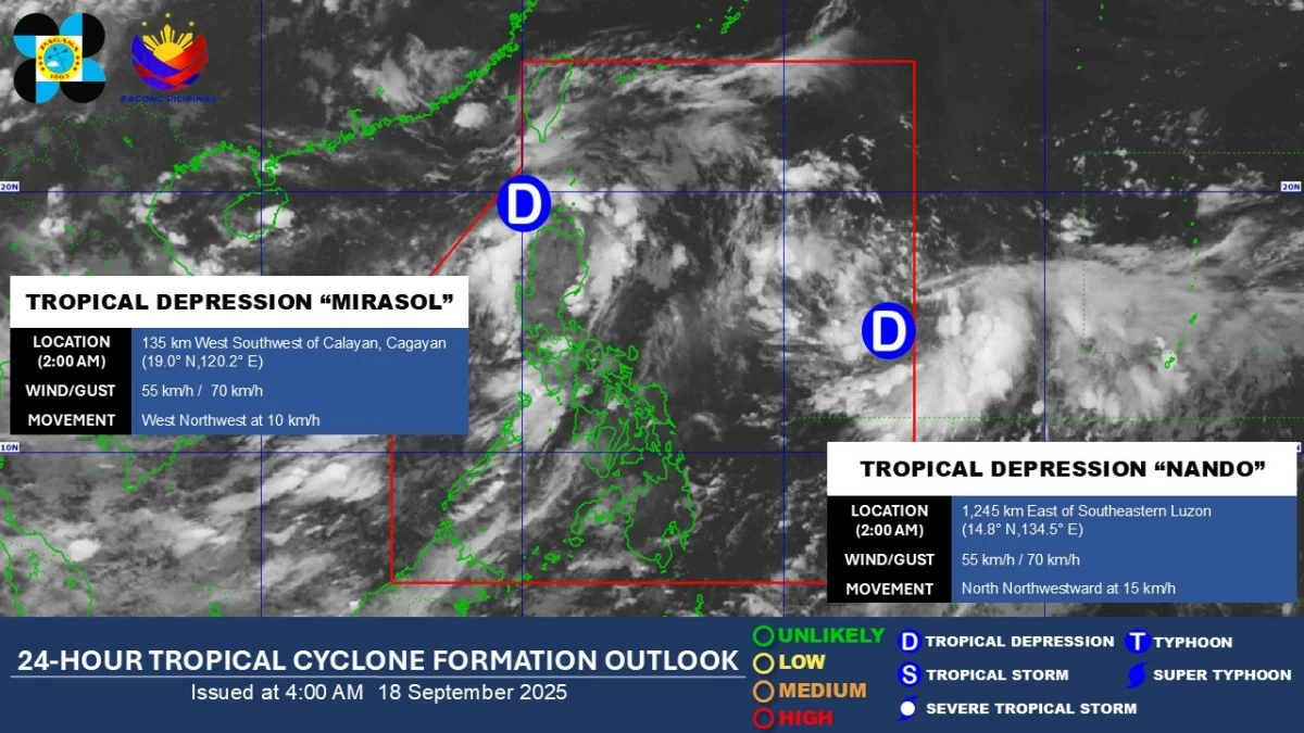
Two tropical depressions are being monitored by the Philippine Atmospheric, Geophysical, and Astronomical Services Administration (PAGASA) on Thursday, September 18, as they continue to influence weather conditions in the Philippines and nearby seas.
In its 5 a.m. bulletin, PAGASA reported that Tropical Depression (TD) Mirasol is moving west-northwestward over the sea west of extreme Northern Luzon.
The agency located the center of TD Mirasol 165 km west of Calayan, Cagayan, with maximum sustained winds of 55 km/h near the center and gusts of up to 70 km/h.
“Mirasol” is expected to exit the Philippine Area of Responsibility (PAR) later today and continue moving toward southern China, where it may make landfall near Guangdong Province by Saturday, September 20. The depression is forecast to intensify into a tropical storm during its passage.
PAGASA said “Mirasol” is currently enhancing the Southwest Monsoon, bringing strong to gale-force gusts over several regions, particularly in coastal and upland areas.
Tropical Wind Cyclone Signal (TWCS) No. 1 is still up Batanes, Babuyan Islands, the western portion of mainland Cagayan (Santo Niño, Camalaniugan, Pamplona, Rizal, Claveria, Lasam, Aparri, Ballesteros, Abulug, Allacapan, Sanchez-Mira, Santa Praxedes), Apayao, the northern portion of Abra (Pidigan, San Juan, Tayum, Langiden, Lagangilang, Danglas, La Paz, Licuan-Baay, Tineg, Malibcong, Peñarrubia, San Isidro, San Quintin, Dolores, Lagayan, Bangued, Bucay, Lacub, Sallapadan), Ilocos Norte, and the northern portion of Ilocos Sur (Sinait, Cabugao, San Juan, Magsingal, Santo Domingo, Bantay, San Vicente, San Ildefonso, Santa Catalina, City of Vigan, Caoayan, Santa, Nagbukel, Narvacan).
TD Nando
Tropical Depression Nando, which entered the PAR late on the night of September 17, remains over the Philippine Sea, moving north-northwestward at 15 km/h.
PAGASA said its center is currently 1,225 km east of Southeastern Luzon, with maximum sustained winds of 55 km/h and gusts up to 70 km/h.
“Nando” could intensify into a typhoon by Saturday, September 20, and possibly reach super typhoon strength as it approaches Northern Luzon and Batanes.
The agency also said “Nando” is expected to enhance the Southwest Monsoon, causing heavy rainfall over the Philippines starting Sunday, September 21, or Monday, September 22.
Wind Signal No. 1 may be hoisted over Northern Luzon as early as Saturday, with higher signals possible if the cyclone intensifies further, PAGASA added.
RELATED STORY: