ADVERTISEMENT

'Nando' now a tropical storm — PAGASA

Possible Babuyan Islands landfall on Sept. 22–23; may further strengthen into a super typhoon

Published Sep 18, 2025 11:55 pm
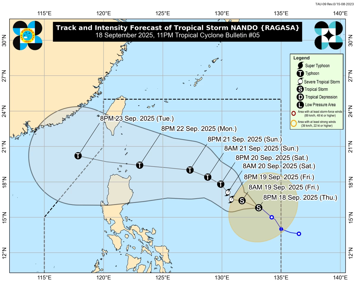
Tropical Storm Nando (int'l name: Ragasa) intensifies over the Philippine Sea, with PAGASA warning of possible Babuyan Islands landfall on September 22–23. Storm may strengthen into a super typhoon. (PAGASA)
Tropical Depression Nando intensified into a tropical storm (international name: Ragasa) on Thursday night, September 18, as it continued moving slowly over the Philippine Sea, according to the Philippine Atmospheric, Geophysical and Astronomical Services Administration (PAGASA).
In its 11 p.m. bulletin, PAGASA said the center of Tropical Storm (TS) Nando was located 1,175 kilometers east of Central Luzon, with maximum sustained winds of 65 km/h near the center and gusts of up to 80 km/h. It is moving west-northwestward.
Based on the forecast track, PAGASA said Nando may pass close to or make landfall over the Babuyan Islands between Monday, September 22, and Tuesday, September 23, before exiting the Philippine Area of Responsibility (PAR) by Tuesday evening.
PAGASA warned that Nando will continue to intensify while over the sea, possibly reaching typhoon category by Saturday, September 20.
The state weather bureau also raised the possibility of Nando becoming a super typhoon, with Signal No. 5 as the highest alert that may be raised during its passage.
“Nando will continue to intensify while over the Philippine Sea and may reach typhoon category by Saturday,” PAGASA said. “Further intensification into super typhoon category while traversing Extreme Northern Luzon is not ruled out,” it added.
Habagat rains, strong winds expected
While Nando is not expected to directly affect the weather in the next 48 hours, PAGASA said it may enhance the southwest monsoon (habagat), which could bring heavy rains by Sunday, September 21, or Monday, September 22.
Strong to gale-force winds are also expected, particularly in the Babuyan Islands, Ilocos provinces, La Union, Pangasinan, and Zambales.
Signal No. 1 may be hoisted over Northern Luzon as early as Saturday, PAGASA added.
Coastal hazards, storm surge risk
PAGASA said TS Nando could trigger moderate to rough seas over most of Luzon’s coastal waters starting Sunday, with wave heights reaching up to 14 meters near Extreme Northern Luzon.
A storm surge warning may also be raised over Northern Luzon coastal areas beginning Saturday.
PAGASA advised residents in Northern and Central Luzon to prepare for possible heavy rainfall, strong winds, rough seas, and storm surges.
Fisherfolk and those with small seacraft are strongly urged to avoid sailing in affected waters.
RELATED STORY: 
https://mb.com.ph/2025/09/16/tropical-cyclone-mirasol-tracker

Related Tags

Tropical Storm Nando 2025 Typhoon Nando update PAGASA weather update Nando Babuyan Islands landfall Nando super typhoon forecast Philippine weather September 2025
ADVERTISEMENT
.most-popular .layout-ratio{ padding-bottom: 79.13%; } @media (min-width: 768px) and (max-width: 1024px) { .widget-title { font-size: 15px !important; } }

{{ articles_filter_1561_widget.title }}

.most-popular .layout-ratio{ padding-bottom: 79.13%; } @media (min-width: 768px) and (max-width: 1024px) { .widget-title { font-size: 15px !important; } }

{{ articles_filter_1562_widget.title }}

.most-popular .layout-ratio{ padding-bottom: 79.13%; } @media (min-width: 768px) and (max-width: 1024px) { .widget-title { font-size: 15px !important; } }

{{ articles_filter_1563_widget.title }}

{{ articles_filter_1564_widget.title }}

.mb-article-details { position: relative; } .mb-article-details .article-body-preview, .mb-article-details .article-body-summary{ font-size: 17px; line-height: 30px; font-family: "Libre Caslon Text", serif; color: #000; } .mb-article-details .article-body-preview iframe , .mb-article-details .article-body-summary iframe{ width: 100%; margin: auto; } .read-more-background { background: linear-gradient(180deg, color(display-p3 1.000 1.000 1.000 / 0) 13.75%, color(display-p3 1.000 1.000 1.000 / 0.8) 30.79%, color(display-p3 1.000 1.000 1.000) 72.5%); position: absolute; height: 200px; width: 100%; bottom: 0; display: flex; justify-content: center; align-items: center; padding: 0; } .read-more-background a{ color: #000; } .read-more-btn { padding: 17px 45px; font-family: Inter; font-weight: 700; font-size: 18px; line-height: 16px; text-align: center; vertical-align: middle; border: 1px solid black; background-color: white; } .hidden { display: none; }
function initializeAllSwipers() { // Get all hidden inputs with cms_article_id document.querySelectorAll('[id^="cms_article_id_"]').forEach(function (input) { const cmsArticleId = input.value; const articleSelector = '#article-' + cmsArticleId + ' .body_images'; const swiperElement = document.querySelector(articleSelector); if (swiperElement && !swiperElement.classList.contains('swiper-initialized')) { new Swiper(articleSelector, { loop: true, pagination: false, navigation: { nextEl: '#article-' + cmsArticleId + ' .swiper-button-next', prevEl: '#article-' + cmsArticleId + ' .swiper-button-prev', }, }); } }); } setTimeout(initializeAllSwipers, 3000); const intersectionObserver = new IntersectionObserver( (entries) => { entries.forEach((entry) => { if (entry.isIntersecting) { const newUrl = entry.target.getAttribute("data-url"); if (newUrl) { history.pushState(null, null, newUrl); let article = entry.target; // Extract metadata const author = article.querySelector('.author-section').textContent.replace('By', '').trim(); const section = article.querySelector('.section-info ').textContent.replace(' ', ' '); const title = article.querySelector('.article-title h1').textContent; // Parse URL for Chartbeat path format const parsedUrl = new URL(newUrl, window.location.origin); const cleanUrl = parsedUrl.host + parsedUrl.pathname; // Update Chartbeat configuration if (typeof window._sf_async_config !== 'undefined') { window._sf_async_config.path = cleanUrl; window._sf_async_config.sections = section; window._sf_async_config.authors = author; } // Track virtual page view with Chartbeat if (typeof pSUPERFLY !== 'undefined' && typeof pSUPERFLY.virtualPage === 'function') { try { pSUPERFLY.virtualPage({ path: cleanUrl, title: title, sections: section, authors: author }); } catch (error) { console.error('ping error', error); } } // Optional: Update document title if (title && title !== document.title) { document.title = title; } } } }); }, { threshold: 0.1 } ); function showArticleBody(button) { const article = button.closest("article"); const summary = article.querySelector(".article-body-summary"); const body = article.querySelector(".article-body-preview"); const readMoreSection = article.querySelector(".read-more-background"); // Hide summary and read-more section summary.style.display = "none"; readMoreSection.style.display = "none"; // Show the full article body body.classList.remove("hidden"); } document.addEventListener("DOMContentLoaded", () => { let loadCount = 0; // Track how many times articles are loaded const offset = [1, 2, 3, 4, 5, 6, 7, 8, 9, 10]; // Offset values const currentUrl = window.location.pathname.substring(1); let isLoading = false; // Prevent multiple calls if (!currentUrl) { console.log("Current URL is invalid."); return; } const sentinel = document.getElementById("load-more-sentinel"); if (!sentinel) { console.log("Sentinel element not found."); return; } function isSentinelVisible() { const rect = sentinel.getBoundingClientRect(); return ( rect.top < window.innerHeight && rect.bottom >= 0 ); } function onScroll() { if (isLoading) return; if (isSentinelVisible()) { if (loadCount >= offset.length) { console.log("Maximum load attempts reached."); window.removeEventListener("scroll", onScroll); return; } isLoading = true; const currentOffset = offset[loadCount]; window.loadMoreItems().then(() => { let article = document.querySelector('#widget_1690 > div:nth-last-of-type(2) article'); intersectionObserver.observe(article) loadCount++; }).catch(error => { console.error("Error loading more items:", error); }).finally(() => { isLoading = false; }); } } window.addEventListener("scroll", onScroll); });

Sign up by email to receive news.