


'Mirasol' to exit PAR on September 18 --- PAGASA
Seven areas under Signal No. 1 likely to experience light to minor effects from strong winds
Published Sep 18, 2025 06:02 am


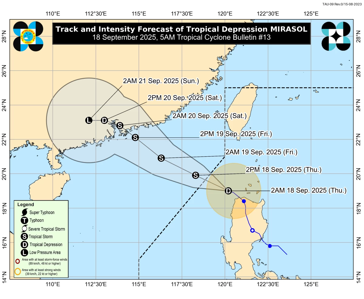
Tropical Depression Mirasol is expected to exit the Philippine Area of Responsibility (PAR) on September 18, 2025. PAGASA said it will continue moving generally northwestward toward southern China, reaching tropical storm strength during its trajectory. (PAGASA)
Tropical Depression (TD) Mirasol is set to exit the Philippine Area of Responsibility (PAR) on Thursday, September 18, according to the Philippine Atmospheric, Geophysical, and Astronomical Services Administration (PAGASA).
In its 5 a.m. bulletin, PAGASA said “Mirasol” is moving west-northwestward over the sea west of extreme northern Luzon and is forecast to continue toward southern China.
PAGASA stated that the center of “Mirasol” is located 165 kilometers west of Calayan, Cagayan, and is moving at a speed of 10 km/h. It maintains maximum sustained winds of 55 km/h near the center, with gusts reaching up to 70 km/h.
TD Mirasol will continue moving generally west-northwestward within the next 24 hours, PAGASA said.
“This weather disturbance will exit the Philippine Area of Responsibility this morning or afternoon,” PAGASA said. “Outside PAR, MIRASOL will continue moving generally northwestward toward southern China,” it added.
Moreover, PAGASA noted that ‘Mirasol’ will intensify and may reach tropical storm category on September 18. “This weather disturbance will likely remain a tropical storm throughout the forecast period before weakening as it makes landfall over southern China by Saturday (20 September),” it added.
Impacts on land and sea
While “Mirasol” remains in PAR, there are seven areas under Tropical Cyclone Wind Signal No. 1, including:
- Batanes
- Babuyan Islands
- Western portion of mainland Cagayan (Santo Niño, Camalaniugan, Pamplona, Rizal, Claveria, Lasam, Aparri, Ballesteros, Abulug, Allacapan, Sanchez-Mira, Santa Praxedes)
- Apayao
- Northern portion of Abra (Pidigan, San Juan, Tayum, Langiden, Lagangilang, Danglas, La Paz, Licuan-Baay, Tineg, Malibcong, Peñarrubia, San Isidro, San Quintin, Dolores, Lagayan, Bangued, Bucay, Lacub, Sallapadan)
- Ilocos Norte
- Northern portion of Ilocos Sur (Sinait, Cabugao, San Juan, Magsingal, Santo Domingo, Bantay, San Vicente, San Ildefonso, Santa Catalina, City of Vigan, Caoayan, Santa, Nagbukel, Narvacan)
PAGASA said these areas are expected to experience minimal to minor impacts from strong winds.
Meanwhile, the weather bureau noted that the southwest monsoon (habagat) is also expected to bring strong to gale-force gusts over Luzon, Mimaropa, Bicol Region, and Western Visayas today, with extended effects across other regions over the next few days.
PAGASA advised mariners of motorbancas and similar vessels to exercise caution or avoid venturing out to sea. Coastal waters along Cagayan, Batanes, Babuyan Islands, Ilocos Norte, Ilocos Sur, and Pangasinan are expected to experience moderate seas, reaching up to 2.0 meters.
RELATED STORY: