


Manila Bulletin
 Philippines
National
DENR urges LGUs to maximize geohazard maps in disaster planning
Philippines
National
DENR urges LGUs to maximize geohazard maps in disaster planning
Philippines
National
DENR urges LGUs to maximize geohazard maps in disaster planning
DENR urges LGUs to maximize geohazard maps in disaster planning
By Jel Santos
Published Sep 18, 2025 01:38 pm


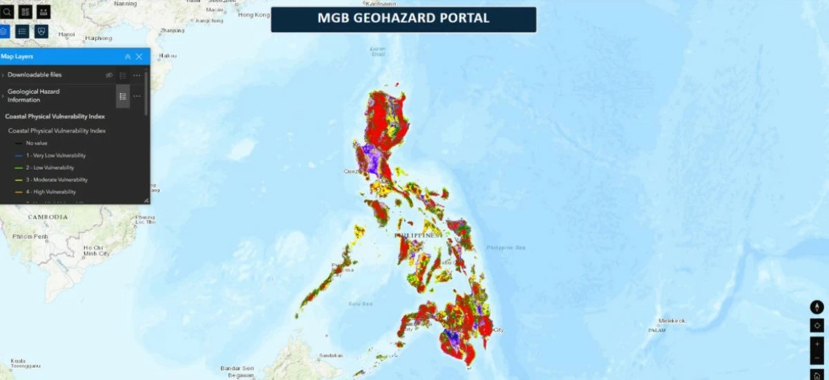
(COURTESY: DENR)
The Department of Environment and Natural Resources (DENR) called on local government units (LGUs) to fully utilize geohazard maps in disaster response and land-use planning as heavy rains raise the risk of flash floods and landslides.
On Sept. 15, the Philippine Atmospheric, Geophysical and Astronomical Services Administration (PAGASA) said La Niña may form by October, potentially unleashing stronger rains and storms that could trigger floods and landslides in at-risk areas.
With the development, PAGASA elevated its ENSO Alert to La Niña Alert, a warning system that indicates the potential emergence of El Niño or La Niña and their effects on Philippine weather.
The DENR said the heightened risk under a possible La Niña makes the use of geohazard maps even more urgent, especially for LGUs crafting disaster and land-use plans.
The DENR-Mines and Geosciences Bureau (MGB), which leads geological mapping and hazard assessments, said the maps were distributed to LGUs to inform their Comprehensive Land Use Plans and disaster risk management programs.
“Private individuals, like households or real property owners, can also view and download these maps, available online on the Geohazard Web Portal of the MGB website,” the agency said in a statement.
The DENR stressed that forecasts from DOST-PAGASA, MGB, and DOST-Phivolcs’ HazardHunter PH must be monitored closely.
“They regularly issue weather forecasts, hazard advisories, and timely updates through their websites and social media platforms,” it said.
Per the agency, barangays are considered flood-prone “if it has a moderate, high, or very high flood susceptibility rating” and when rainfall exceeds thresholds set by DENR-MGB.
In addition, the environment department said that “areas located on steep slopes or that have weak and heavily weathered foundation material are more likely to experience landslides.”
The DENR said early warning signs must be reported immediately.
“Immediately report cracks in the ground, floors, walls, or around doors and windows and any tilting of structures or water seepage from slopes to barangay officials and the MGB for proper assessment,” it said.